Part One: Pre-Logging
The Kichi Sipi, also known as the Ottawa River, is the thirteenth longest river in Canada. The rivers’ one hundred and forty-six thousand square miles watershed is bisected by the Sibi’s serpentine route as it curls back on itself going west from its source north of Ottawa, then heading southeast from Lake Témiscamingue to the St Lawrence River. It is the traditional unceded territory of the Anishinabe-Algonquin Nation. From the interior, sixteen major tributaries flow from various large headwater lakes to form multiple access routes into the watershed. The only major tributary to have never been dammed, settled, or industrialized save for logging, is the Dumoine. It is now protected as a Quebec aquatic reserve (2008) along with the Coulonge and Noire (2023).
The Kichi Sibi is the watershed that defined the Anishinabe-Algonquin history for time immemorial. Groups of Anishinabe families separately identified themselves as unified self-regulating custodians for ‘their tributary . ’ Together they all formed the Anishinabe-Algonquin Nation. Each family (10-20 related individuals) was assigned approximately a thousand square mile hunting territory, orally defined using natural feature boundaries, and protected by customary law. The Dumoine was a popular route for other nations to cross the Algonquin territory. The Dumoine families, of course, used it frequently to paddle to Algonquin rendezvous for social events. These events were centred on trade, religion, and customary law. The summer wanderings of the families were focused on seasonal harvesting of spawning fish and eels, birds migrating, maturing of fruit, vegetable and medicinal plants, and the gathering of raw materials. These materials were used for creating canoes, hunting and cooking tools, clothing, footwear, dwellings, baskets, and infant cradles. All these goods were often decorated with impressive artwork. The Dumoine group of families, known first to the Jesuits and Champlain as the Otaguottouemin, were identified two centuries later in government documents as the Dumoine Band. Their story is typical of those Algonquins that lived for centuries along the major tributaries.
Long before the Europeans arrived, the Dumoine Band maintained a lifestyle that involved wintering in their designated hunting territories while hunting and trapping. They used the paddling season for travelling throughout the watershed. The chiefs endorsed a few adventuresome individuals to participate in war or trade missions further afield. A wide variety of other First Nations traders brought goods to these families, most often at the trading site at the mouth of the Dumoine. These goods originated from the Mississippi watershed, the Great Lakes, the James Bay, and the Atlantic Ocean, so a variety of food, goods, and cultural ideas penetrated the interior long before the first white man arrived.
The mouth of Dumoine featured a long sandy spit that rose gracefully up into the pine forest as a grass-covered gravel bar capable of growing root crops. It formed a perfect camping and trading site. The Wolf Lake elders (2022), the direct descendants of the Dumoine families, shared with us the name Akonakwasi for this site meaning ‘a long stretch of sand extending far away’ adding Sakik for the mouth and Sibi for the river (now underwater since the Rapides des Joachims dam was built in 1950).
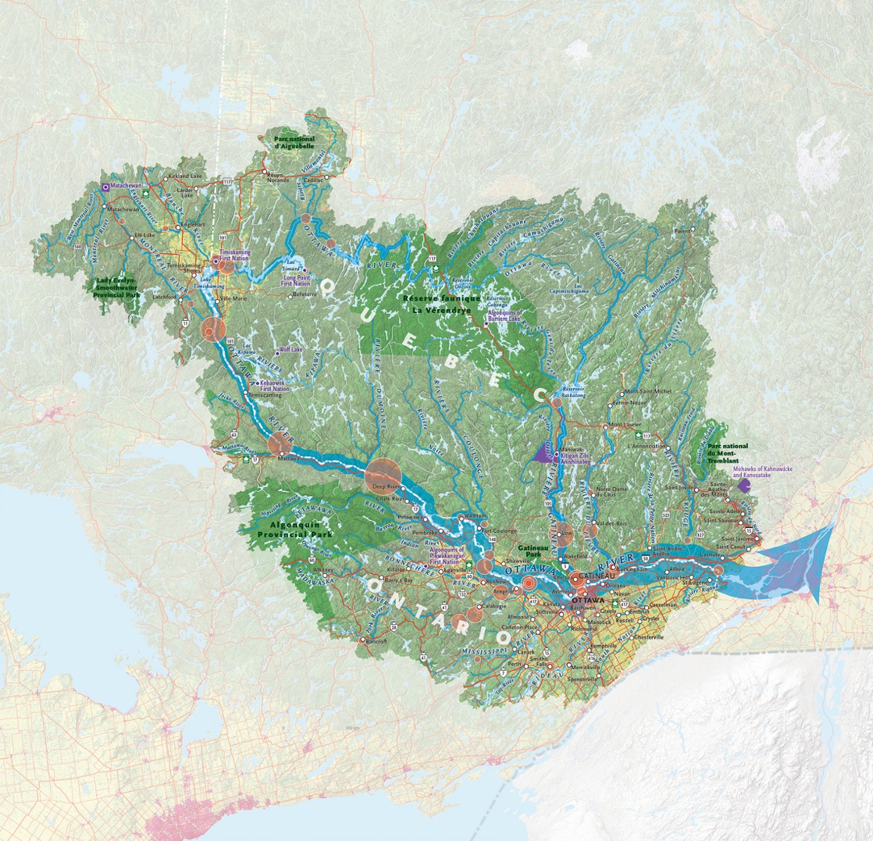 Canadian Geographic map of Ottawa River Watershed.
It is a challenging four day paddle up the Dumoine which rises one hundred vertical feet as falls, chutes and rapids from the mouth to Lac Dumoine. The creation of magnificent Lac Dumoine is as difficult to imagine being done by a retreating glacier, carving out this eighty-one square mile lake as it is to imagine Nenabojo (also known as Wiske’djak the Anishinabe trickster) chasing a giant beaver out of the south end churning up the land and forming the Dumoine River in the process. But both are accepted stories in different cultures. Lac Dumoine (Anishinabe name is Keewagama one of the many accepted spellings) is unique for four long outlets stretching in each cardinal direction and with a river entering or exiting each. It is a natural traffic circle and has served as an important crossroads for trade and travel since the melting glacier filled it.
French explorer, Samuel de Champlain, was one of the first white men to travel the Kichi Sibi in 1613, preceded by his youthful emissaries Étienne Brûlé and Nicholas de Vignau (1611). Some Anishinabe met white men earlier (i.e. Champlain in Tadoussac in 1603) on their travels outside the watershed. Priests often accompanied Champlain and his emissaries, reflecting that their mission to convert Algonquins (and also exploration) was a priority from France. Champlain himself functioned as both an explorer and soldier, representing New France as an ally of the Algonquins and Hurons against the Iroquois.
Prior to contact with the Europeans, the Algonquin economy had centred on trading furs, dried foods, and hand-crafted products, like birch-bark canoes and other practical implements. After contact, the focus on trade changed to European manufactured goods for furs. From 1620-1700 the Iroquois (Haudensaunee) Confederacy attacked the region of the Kichi Sipi because of their desire to influence the beaver fur trade south to their territory. They sent their warriors north to control the Kichi Sibi trade with attacks originating along many of the major portages along the Ottawa River and as far north as the James Bay height of land. It was tributaries like the Dumoine that provided detours north then east to the French trade centres of Montreal and Trois-Rivières for those trying to avoid the Iroquois. Beginning in 1670 (Royal Charter), the new Hudson's Bay Company was attracting Cree and Anishinabe fur traders north to James Bay. In 1686, to protect the business interests of the merchants of New France, Pierre Le Moyne, Chevalier de Troyes d`Iberville, with the assistance of Anishinabe guides, led French Marines from Montreal up the Ottawa River to attack the British posts on James Bay.
The European trade and the Catholic religion influenced the Dumoine family life by the 1600s. Trade brought metal tools, pots, traps, firearms, woollen blankets and clothing, and other luxuries into the family unit. It also brought disease and alcohol. The Black Robes (Recollects, Jesuits, Sulpicians and finally the Oblates) brought Catholicism to the Algonquins. Being a Catholic (approximately half the Anishinabe population converted) required an annual pilgrimage to the Sulpician mission at Oka near Montreal to be properly baptized, married, or buried as a Catholic. However, beginning in the 1830s, the Oblates built mission churches closer to the Dumoine beside Hudson’s Bay Company posts located at Fort William, Fort Témiscamingue and Fort Grand Lac Victoria, resulting in the elimination of this pilgrimage. The route to the mission at Grand Lac Victoria was up the Dumoine from the Kichi Sibi. Oblate priests, guided by Algonquins may have named the river ‘the river the monks travel.’ This was translated onto maps as Rivière du Moine (Hawkins 1836) and later map makers anglicized this to the Dumoine River.
There were temporary trading posts set up at the Dumoine each spring. Starting with trading posts that independent traders set up in the 1700s, followed by the Northwest Company from 1790-1820, and finally the Hudson’s Bay Company, whose trading posts lasted from 1821 to 1840.
Lumberjacks mixed their French, Irish and English accents together to create the unique phrase for travelling to their new workplace “Going Up da Dumun.” Roderick Ryan was the first lumber baron who used the mouth as a base for his operations for travelling upriver circa 1840. He and John Egan lead an invasion of a new type of economy away from furs and at the expense of the Algonquin Dumoine family way of life. The story of Roderick Ryan and John Egan will be shared in Part Two this blog.
Wallace A Schaber
I am not a professional historian or Anishinabe expert. I am a collector of maps, stories, and artifacts about the Dumoine based on fifty years of guiding there by canoe, ski, and foot. Many of these stories are found in my book, Last of the Wild Rivers (2016), which is out of print but available as an e-book online.
Friends of the Dumoine
In 2016, concerned Dumoine guides and travellers formed Friends of Dumoine to keep the rivers portages and campsites clean.
Mission Statement
“To champion conservation of the Dumoine watershed, promote non- mechanized recreation and strengthen knowledge of its natural environment and human history.”
Our major achievement to date is the re-opening and interpretation of the old Anishinabe portages that existed for centuries and linking them to the Dumoine tote road used by the lumber industry beginning in 1840. This hiking trail is now open from the Ottawa River to Grande Chute as a twenty-six kilometre hiking-skiing trail www.sentierdumoine.ca. A visitor centre at Grande Chute complete with historic maps and artifacts is located at the northern gateway.
Please join us on the trail or virtually online to explore Canada's history and protect it. For more information about how to volunteer or donate write This email address is being protected from spambots. You need JavaScript enabled to view it..
Friends of the Dumoine would like to thank our partners in helping to make this project a reality.
CPAWS Ottawa Valley
ZEC Dumoine
Wolf Lake First Nation
References and Further Reading
Fournier, J-L. Anishinabe Place Names for the Dumoine Hiking Trail, confirmed and sanctioned by Wolf Lake First Nation, May 2022. Prepared for Friends of Dumoine Trail Map published 2024.
Morrison, James. “Algonquin History in the Ottawa River Watershed.” Sicani Research & Advisory Services Ottawa, Ontario, Revised 2005.
Frank G. Speck. “Myths and Folklore of the Timiskaming Algonquin and the Timagami Ojibwa.” Canada Department of Mines. Geological Survey, Memoir 71, No 9 Anthropological Series. Ottawa: Government Printing Bureau, (1915):1-3.