Working to preserve Ottawa's past
for future generations.
Since September 2020, the Historical Society of Ottawa has presented a virtual speakers series using Zoom. A full recording of those presentations is available on the HSO YouTube channel and shown here as well.
The Historical Society of Ottawa does not necessarily subscribe to views expressed in these videos, nor take any responsibility for their content.
Arrested Development
If you missed the HSO presentation by Phil Jenkins (or you just want to watch again) check out his recap and reflections on the history of LeBreton Flats in this video from April 14, 2021.
Everybody Out!
18 April 1962
It came without warning; a notice addressed to residents of LeBreton Flats reading “This letter will advise you that on April 18, 1962, the National Capital Commission [NCC] filed a notice of expropriation covering the property at [your address.]” With that, 2,800 residents, along with hundreds of businesses, were obliged to move. They were given two years to relocate. The decision to raze the neighbourhood was taken without public consultations, presumably to avoid land speculation. Even Ottawa’s mayor, Charlotte Whitton, was kept in the dark.
In total, 53 acres of land was forcibly acquired from 240 landlords. The government paid fair market value for the land at a cost of about $17 million. The expropriation was part of a project to redevelop the entire LeBreton Flats area of roughly 154 acres. The federal government already owned 60 acres of railway yards and tracks purchased from the Canadian Pacific Railway in an initiative to remove trains from downtown Ottawa. Another 29 acres were to be reclaimed from Nepean Bay, with streets accounting for the remaining 12 acres. The last building to fall to the wrecking ball was the Duke House, the former Couillard Hotel, in October 1965. More than 250 people had crowded into the tavern the previous St Patrick’s Day, its last day in operation, to celebrate its passing. With the Duke House’s demolition, LeBreton Flats, a historic neighbourhood that dated back to the mid 19th century, was nothing but a memory. Its final days were memorialized in oil paintings by local artist Ralph Burton which now hang in the Ottawa City Hall.
The rationale for the expropriation was to eliminate “a real eye sore” of deteriorating housing stock and dirty industry within walking distance of Parliament Hill. The NCC planned to transform the area into something worthy of a national capital, with the construction of up to ten government buildings, along with monuments, parks and parkways. Notwithstanding Prime Minister Diefenbaker’s ambition to complete the project in time for Canada’s centennial on 1 July 1967, Lebreton Flats remained a barren wasteland of weeds, rubble, car parks, and snow dumps for more than 40 years.
There are a myriad of explanations for what went wrong. Changing priorities, cost, recessions, ineptitude, and the discovery of toxins in the soil all played a part in slowing the Flats’ renaissance. The fact that the area was owned for much of the time by three different levels of government, the NCC, the regional government, and the City of Ottawa, didn’t help either.
Many have questioned the original decision by the NCC to bulldoze the Flats, viewing it as a crime committed against the poor. Some look back with nostalgia to a neighbourhood, while hardscrabbled, had a sense of community. But others argue that LeBreton Flats was a gritty, dirty slum. Many of its buildings had been hastily constructed after the 1900 fire which had gutted the area. Only two structures had survived the flames, one ironically being the Couillard Hotel, the last building to demolished in 1965. By the early 1960s, the area was unquestionably rundown, an unhealthy mix of dilapidated houses, scrap yards, metal working plants, mill suppliers, and rail yards. Odours from a paint factory and a brewery poisoned the air.
Regardless of the merits of levelling LeBreton Flats, the fact that the NCC left the brown-field site fallow for more than a generation beggars belief. A succession of proposals was announced for the site with great fanfare only to submerge without a trace. In the late 1960s, the area was to become home of a new headquarters for National Defence. But the three-tower, $40 million project never got off the ground; cost considerations were the likely reason. Instead, National Defence moved to its current location on Colonel By Drive. Subsequent plans for the Flats included a highway interchange with a half-clover leaf, low-cost housing, a convention centre, a national aquarium, a railway terminal for a proposed high-speed train between Windsor and Montreal, and a theme park. While waiting for the NCC to decide, the Flats have been used for special events, including an open-air mass by Pope Jean Paul II in 1984, and performances by the Cirque du Soleil. The land has also been used as a site for hot-air ballooning and as a camping ground.
In the late 1980s, plans for the area focused on five competing concepts with beguiling but obscure names: “Consolidating the Capital,” “Symbolic Bridge,” “A Multi-use Node,” Creating an Urbane Capital,” and “An Agora for the Capital.” Each was assessed on their biophysical, social-cultural, and other characteristics. Under the winning “Agora” concept, the Flats would be populated with museums, offices, roughly 2,500 residential units, of which 1/3 would be social housing, and commercial buildings. There would also be ample green space, including a park (the agora), located in the centre of LeBreton Flats. The Ottawa River Parkway (now Sir John A. Macdonald Parkway) would be relocated to become an urban boulevard through the Flats.
This plan too stalled, in large part on a 1991 environmental study that detailed the various toxins found in the soil and groundwater of LeBreton Flats, a legacy from its industrial past. Before redevelopment could take place, measures would have to be taken to deal with high levels of benzene and other contaminants that had leaked into the soil from the paint factory, underground oil tanks, and waste disposal sites. Snow dumps had also lead to high levels of lead from vehicle emissions, and chloride in the groundwater. Dangerously high levels of methane from rotting household and municipal wastes used as infill were also found in the land reclaimed from Nepean Bay. The cost of remediation and clean-up, which included scrapping off and replacing the topsoil, had risen to more than $70 million by 2012.
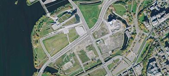 LeBreton Flats, circa2010After more than 40 years of delay, the redevelopment of the LeBreton Flats finally got underway in 2003 with the construction of a new Canadian War Museum. Located close to the Ottawa River, the facility, which cost more than $135 million, opened its doors to the public in 2005. Its environmentally-friendly “green” roof is planted with self-sowing grasses found along the Ottawa River. The fields to the south and east of the Museum are currently used for summer festivals, such as Bluesfest.
In 2004, the NCC contacted developers regarding the construction of residential units on a large 11 acre (4.4 hectares) parcel of land. Only three developers, Minto, Alliance Prevel and Claridge, submitted expressions of interest. Controversially, when decision time came, Claridge, judged third on experience and design, was the only contender left standing. The other two had pulled out of the competition owing to changes demanded by the NCC which in their view had made the project nonviable. Since then, Claridge has built two 13-storey condominium towers on LeBreton Flats which some critics panned as “pedestrian.” A third phase consisting of “boutique-style stacked townhomes” is underway.
The LeBreton Flats odyssey is far from over. More residential units are planned though their timing will depend on market demand. The decision to build a light rail transit (LRT) system in Ottawa has also affected development on the Flats. On the positive side, LeBreton Flats will have its own stop, better linking the area to the rest of the city, and increasing its attractiveness to potential residents. On the negative side, the LRT project has prompted the NCC to reassess its approach to the Flats. In September 2014, the Crown Corporation abandoned its twenty-year old plans for mixed-use development for the area saying that they were out-dated and inconsistent with contemporary approaches to development and city needs. It now wants a “signature” attraction of regional, national, or even international significance. Ideas including a downtown hockey arena, or a new site for the Museum of Science and Technology. While the federal government supports this change in direction, it has also indicated that it has no money to finance development. The NCC has invited the private sector to submit proposals for 9.3 hectares of land south of the Parkway and west of Boothe Street. An additional 12.1 hectares might also be made available. The hope is that something could be approved by the NCC Board and the federal government by early 2016.
Sources:
Jenkins, Phil, 2008, An Acre Of Time, Chelsea Books.
McClelland, David, 2009, “The Ottawa Project".
National Capital Commission Planning Branch, Environmental Assessment Section, 1991, LeBreton Flats/Bayview Concept Plans: Initial Environmental Evaluation, Final Report, May.
NCC Watch, The LeBreton Flats.
Ottawa Business Journal, 2012, “Construction crews returning to LeBreton Flats in December,” 29 August.
Ottawagraphy, LeBreton Flats.
Ottawa Sun, 2012, “Cost of Cleaning up Contaminated Soil at Ottawa’s LeBreton Flats would top $71 million, National Capital Commission says,” 22 December.
Rappaport, Michael, LeBreton Flats: Ottawa’s Field of Dreams.
The Ottawa Citizen, 1962, “Huge Expropriation, 10 Gov’t Buildings Planned to”Beautify” Central Area,” 19 April.
———————, 2013, NCC to rethink plans for LeBreton Flats,” 31 August.
——————–, 2014. “Everything you need to know about the NCC’s vision for LeBreton Flats,” 30 September.
The Globe and Mail, 1970, “Paid $1,771,966 for unused HQ Plan,” 20 January.
Trailpeak, 2013, LeBreton Flats, 1950s.
Urbsite, 2010, Ralph Burton on Lebreton Flats.
—————, 2012, Revisiting the Flats after 50 years (and 100, 150, 200 years).
Images:
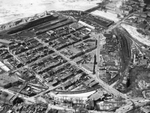
LeBreton Flats, circa 1960.
LeBreton Flats, circa 2010.
Story written by James Powell, the author of the blog Today in Ottawa's History.
Retired from the Bank of Canada, James is the author or co-author of three books dealing with some aspect of Canadian history. These comprise: A History of the Canadian Dollar, 2005, Bank of Canada, The Bank of Canada of James Elliott Coyne: Challenges, Confrontation and Change,” 2009, Queen’s University Press, and with Jill Moxley, Faking It! A History of Counterfeiting in Canada, 2013, General Store Publishing House, Renfrew, Ontario. James is a Director of The Historical Society of Ottawa.
Ottawa’s Rink
18 January 1971
While Ottawa is a great place to live, even its most partisan citizens would have to agree that at life’s great banquet, it got a double helping of winter. On average, Ottawa receives roughly two metres of snow each year over a season that lasts from early November to well into April, with temperatures dipping to -30 Celsius. Consequently, to live happily in Ottawa, it’s important to embrace the season. Fortunately, we have access to lots of winter amenities, including wonderful ski trails and slopes in the Gatineau Hills just a short car ride away. But one of the city’s winter crown jewels is the Rideau Canal Skateway, which runs 7.8 kilometres through the heart of the city from the Ottawa River locks beside Parliament Hill to the Hartwell Locks at Carleton University. Each year, Ottawa citizens eagerly await the start of the winter skating season, checking regularly the National Capital Commission’s (NCC) web site or its information line on the state of the ice. Requiring an ice thickness of at least 30 centimetres, it takes at least a couple of weeks of temperatures persistently below -15 and a lot of hard work by NCC staff to prepare the ice surface before the Skateway can be safely opened to the public.
Typically, the skating season starts in early January and remains open until mid-March, though the Canal might close for short periods owing to temporary thaws. The earliest opening date occurred on 18 December 1971 and 1982. Its latest closing date was 25 March 1972. The average season is about 50 days, of which 42 are skating days. The longest season was 1971-72 with 95 days, while the shortest was 2015-16 with 34 days, of which only 18 were skating days. Even then, the skateway was open for its entire length for ony a few days. In contrast, the canal was open for a record 59 consecutive days during the previous 2014-15 season, attracting an estimated 1.2 million visitors. In general, however, shorter and milder winters associated with climate change is shortening the skating season.
Skating on the Canal has in fact been a feature of the City’s winters since the 19th century. In March 1874, The Globe newspaper reported that there “was good skating on the Rideau Canal.” The ribbon of ice running through the city beckoned youngsters of all ages when climatic conditions were just right for a smooth, solid ice surface to form—low temperatures for several days with little snow. When that happened, skaters would descend on the Canal to enjoy the ice. On one occasion early in the 20th century, it was reported that people could skate all the way from Lisgar Collegiate to Sunnyside without benefit of snowploughs or sweeping.
At best, however, the city tolerated impromptu skating on the Canal. When times became more litigious, it forbade it owing to the risk of injury, or even death. Although the water is partly drained from the Canal each fall, it is sufficiently deep in places for people, especially children, to drown should they fall through the ice. Despite the risks, skating on the Canal captured the imagination of Ottawa’s citizens who recalled Dutch paintings of skaters on the canals of Holland. If they can do it in the Netherlands, why can’t we do it in frigid Ottawa?
Conditions were perfect for skating during the winter of 1958-59, and attracted thousands onto the ice on the Canal, Dow’s Lake, and even the Ottawa and Rideau Rivers. Owing to public demand, the city’s Parks and Recreation Department asked Ottawa’s Board of Control for $16,000 to maintain a one mile length of canal between Patterson Creek and Bank Street, complete with ramps, changing huts and lightening, for the following winter season. Instead the City coughed up only $2,000, enough for a ramp at Fifth Avenue and a skating lane. It was maintained for just over two weeks from 15 December 1959 to 2 January 1960. Four men and two ploughs mounted on jeeps were unable to keep up with the snow. As well, twenty men using four water pumps were required to keep the ice surface smooth. But as the water was drawn from under the ice, city officials feared that air pockets might form leading to cave-ins. With attendance low, averaging only 30 skaters per day, the experiment was abandoned on 5 January, ending Canal skating for more than a decade.
Despite this setback, people kept the faith. In 1969, the National Capital Commission proposed the establishment of an ice rink on the Canal as a way of “finding imaginative and enjoyable uses for unused resources.” But even as late as December 1970, there were naysayers. In an editorial, the Ottawa Citizen opined that the “durable proposal” of Canal skating was “going nowhere.” Instead, it favoured a temporary outdoor rink with artificial refrigeration be installed by the National Arts Centre across from the Canal.
Douglas Fullerton, the redoubtable chairman of the NCC from 1969 to 1973, would have none of it. On 18 January, 1971, he sent teams of men with shovels to clear a five kilometre stretch of ice, twenty feet wide, from the Arts Centre to the Bronson Street Bridge. It was an instant success; 50,000 Ottawa residents flocked to the canal during the rink’s first weekend to enjoy the experience of skating through the heart of the city. There were glitches, however. During the second year of operations, the shelters provided on the ice for skaters sank. They were subsequently placed on gravel pads. Clearing the snow off the ice and maintaining a smooth ice surface suitable for skating also took considerable on-the-job learning. Within three years, however, NCC crews had improved their technique sufficiently to permit virtually the entire width of the Canal to be cleared for its full 7.8 kilometres length through the city. Changing facilities, bathrooms, skate-sharpening facilities as well as first aid centres were established. Refreshment stands served snacks, hot chocolate, coffee and cider to cold, weary skaters. To facilitate night time skating, lights were added.
In 1979, the NCC inaugurated the first annual Winterlude, or Bal de Niege winter festival featuring winter-related activities as well as snow and ice sculptures. It too was a great success. Naturally, its events centred on the Canal; so much so that Fullerton became concerned that Winterlude might detract from the skating. His fears were misplaced. Winterlude became a major tourist attraction and has attracted thousands of new visitors to the Skateway each winter. Ottawa is now a major winter tourist destination.
For many years, the Rideau Canal Skateway billed itself as the longest natural ice skating rink in the world. However, during the mid-2000s, Winnipeg’s River Trail usurped the title. Measuring 9.32 kilometres in length in 2009, it easily topped the Canal for length. Ottawa residents sniffed that Winnipeg’s Trail, which narrowed in places to no more than a car width was a poor excuse for a rink. Ottawa MP Paul Dewar called it a “cow path” in a tongue-in-cheek exchange with his Winnipeg colleague in the House of Commons. Today, Ottawa’s Skateway claims to be the “largest” outdoor skating rink in the world, equivalent to 90 Olympic-sized hockey rinks, a boast supported by the Guinness Book of Records.
Sources:
Canadian Geographic Travel Club, 2009. “Skating: The Cold War,”.
Capital News Online, 2014. “The history of a record making rink,”
Forks North Portage Corporation, 2014. Red River Mutual Trail,.
New Straits Times,” 1975, “Ice-Skating, The Popular Winter Sports,” 29 June.
National Capital Commission, 2014. “Rideau Canal Skateway,”.
OttawaKiosk.com, 2005. “Fact Sheet-Rideau Canal Skateway,”.
The Age, 1974. “Skate Along Ottawa’s five-mile waterway,” 4 November.
The Citizen, 1984. “Evolution of Ottawa’s Rink,” 7 February.
The Globe, 1874. ”Latest from Ottawa,” 6 March.
The Globe and Mail, 2008. “Only in Canada: Two frozen cities face off over ice,” 8 January.
The Ottawa Citizen, 1960. “Skaters’ Wish Coming True With Rink At Mooney’s Bay,” 20 December.
———————–, 1971. “Canal Open—Night Skating On Its Way,” 24 December.
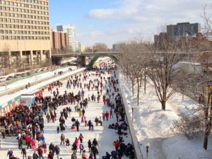
Image: skating on the Rideau Canada, February 2014 by Nea Powell
Story written by James Powell, the author of the blog Today in Ottawa's History.
Retired from the Bank of Canada, James is the author or co-author of three books dealing with some aspect of Canadian history. These comprise: A History of the Canadian Dollar, 2005, Bank of Canada, The Bank of Canada of James Elliott Coyne: Challenges, Confrontation and Change,” 2009, Queen’s University Press, and with Jill Moxley, Faking It! A History of Counterfeiting in Canada, 2013, General Store Publishing House, Renfrew, Ontario. James is a Director of The Historical Society of Ottawa.
Quick Links
About
Supporting Partners