Working to preserve Ottawa's past
for future generations.
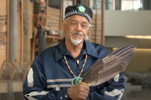
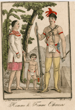
Lynn Gehl – Algonquin Anishinaabeg of the Ottawa River Valley: Yesterday, Today & Tomorrow
The Historical Society of Ottawa’s Zoom presentation of February 11th, 2026, was the 1 st of a 3 part series on the beginning of the Rideau Canal, (March 28), and the founding of Bytown, (April 25), in recognition of 2026 being the 200 th anniversary of both. We started the series with a look at the effects these events had on the Algonquin Anishinaabeg peoples. We were pleased to welcome Dr. Lynn Gehl, noted academic, author, artist, and advocate. She is a member of the Algonquins of Pikwàkanagàn First Nation . Dr. Gehl holds a Doctorate in Philosophy in Indigenous Studies as well as a Masters in Canadian Studies and Indigenous Studies and an Undergraduate degree in Cultural Anthropology. She is also the recipient of a Governor-General’s award.
The evening’s presentation took a conversation format, with questions being posed by Ben Weiss, long time member of the Historical Society of Ottawa, and Dr. Gehl, both providing specific answers and using the questions as a lead to discuss related issues. To get the full impact of the information and perspective provided by Dr. Gehl, we encourage you to watch the presentation or check out her other works through the links provided below.
Ben Weiss: Can you start off by telling us about your early life?
Dr. Gehl: Dr. Gehl started us back with her Great-grandfather, Joseph Gagnon and Great-grandmother Annie Jane. They lived on what was then known as the Golden Lake Reserve, but after returning wounded from the First World War, Joseph was advised by the government to move off the reserve to receive benefits. Dr. Gehl’s father grew up in the area and was a fisherman on the lake. Her mother went to Residential School in the Montreal area. Dr. Gehl is the 5 th of 8 children, and after the breakup of her parents, her mother raised the 8 children in the Toronto area. She suffered through poverty, housing and food insecurity and a series of operations that attempted, unsuccessfully, to correct a medical issue. As a youth, she found reading and writing difficult, both due to a vision impairment and because her focus was, by necessity, more on physical survival than intellectual development. She wanted to share these aspects of her personal story so others would recognize that she is not approaching these issues as a person of privilege.
Ben Weiss: You are now our foremost Indigenous scholar. Could you take us through a bit of your academic journey?
Dr. Gehl: Dr. Gehl confirmed that reading is still a burden for her, but she does a lot of it and has what may be the largest Algonquin library existent. At 30, she decided to leave her job monitoring water quality for the Ontario Provincial government to pursue her desire to understand what had happened to the Algonquin people. She started as a part-time student in Psychology, later switching to anthropology that better matched her interests. Her studies in anthropology revealed to her that there are many ways to be a human being and that poverty is often related to the power system in place. For her Masters work, she investigated the question of identity and the way it has been assessed. Are you Indigenous because you look Indigenous? Are you Indigenous as the result of a blood test or are you Indigenous because the government has said you are Indigenous. She was concerned how this assessment, especially when the identity is denied, affects the spirit of the individual. For her PhD, Dr. Gehl switched topics and studied the Algonquin Land Claims Process. Her findings were later converted into a book, The Truth that Wampum Tells: My Debwewin on the Algonquin Land Claims Process – Fernwood Publishing . Unlike most who find the results of her PhD a happy one, Dr. Gehl characterized hers as brutal, as an understanding that Canada has yet to move past its colonial period.
Ben Weiss: Could you tell us about your decades- long struggle around the key issue of unknown or unstated paternity inside the Indian Act, Gehl v Canada ?
Dr. Gehl: Dr. Gehl explained that in 1985, the government amended the Indian Act and she thought that they would remove sex discrimination from the Act, which they did not. They instead added additional stipulations that they falsely claimed would bring the definition in line with the Charter. As a result, Dr. Gehl, then 23, approached the Aboriginal Legal Services of Toronto to see if they would accept her case challenging the Act. She found herself, one individual taking on the Department of Justice. After much archival research, a dismissal in 2012, a verdict against her in 2014, she finally received a partial victory from the Ontario Court of Appeal in 2017. Dr. Gehl explained that at this time, Sharon McIvor was going through a similar struggle and, in 2010, had petitioned the United Nations Human Rights Commission, who found in her favour in 2019 (McIvor Case | The Canadian Encyclopedia). Dr. Gehl pointed out that though her fight lasted 34 years, her Great-grandmother had written a letter, in 1945, asking about her status following the death of her husband and was informed that she was now a “White Woman”.
Ben Weiss: Can you take us through the concepts of Indigenous knowledge and the Debwewin Journey?
Dr. Gehl: Dr. Gehl explained that when she was completing her Indigenous Studies PhD, she made the decision to do so through Indigenous knowledge and Indigenous ways of knowing and being. She did this by getting as much exposure to Indigenous knowledge as she could, through the literature, ceremonies, talking with Elders and by learning the language. In this process, she learned of the concept of “Heart Knowledge” and gave the example of looking at each other when we talk so we can tell that we are being truthful. Dr. Gehl discovered that truth exists when our “Mind Knowledge (reasoned knowledge) and our “Heart Knowledge” agree. She developed this understanding into a Methodology, the Debwewin Journey .
Ben Weiss: Can you tell us something about Algonquin contact and pre-contact history?
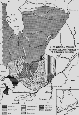
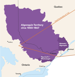
Dr. Gehl: Dr. Gehl reminded us that the history of Canada is taught as the French and English being the benevolent founders of the nation. This is obviously untrue. She noted that the Algonquin territory covers some 200,000 square miles, larger than the combined lands of Prince Edward Island, New Brunswick and Nova Scotia, yet the Algonquin peoples have little control over this territory. The European historic record dates as far back as 1613, when Champlain documented the control of the territory by the Algonquin. After the British defeated the French to gain control over these lands, they signed a treaty in 1760, vowing to protect Indigenous lands, which they later broke. Dr. Gehl detailed a number of treaties and a Royal Proclamation, that defined Algonquin lands, as far as the governments of the day were concerned, eventually resulting in 2 federally recognized Algonquin First Nations in Ontario and 9 in Quebec, though some actually have no land associated with them. There are also 4 unrecognized Algonquin collectives in Ontario. The Algonquin lands in Ontario were lost through a series of treaties signed by the Mississauga peoples, not the Algonquin. Dr. Gehl noted additional pieces of legislation that granted Algonquin lands to settlers, but not to Algonquin peoples, and remarked that Parliament itself is built on stolen Algonquin land.
Ben Weiss: Do the Algonquin have any land treaties?
Dr. Gehl: No. Dr. Gehl explained that the only treaties that cede their lands are those signed by the Mississaugas. There are, however, Peace Treaties, such as the Treaty of Niagara, which identified the 24 Indigenous nations attending as Nations, but also as Subjects. They were, in fact, allies, of equal status to the British.
Ben Weiss: What is the significance of the Wampum Belt in Indigenous culture?
Dr. Gehl: Dr. Gehl explained that a Wampum Belt is a form of symbolic literacy, just like words on a page. Though many believe that only the Haudenosaunee used Wampum Belts, this is not true; Wampum Belts were used by a number of peoples including the Algonquin. Wampum Belt Diplomacy was often used to codify agreements, such as those between Indigenous Nations and the British Crown.
Ben Weiss: Why is it important to understand the significant difference between what Canada calls the Modern Treaty process and the Land Claims process?
Dr. Gehl: It is crucial. Dr. Gehl explained that a Treaty Process is about sharing the land and resources in equal and equitable ways. A Land Claims process is about extinguishing Indigenous Rights. Canada’s Modern Treaty process is simply a Land Claims process. The Canadian government is currently offering the Algonquin Nation only 1.7% of their territory and a one-time buy-out of $800 Million.
Ben Weiss: Can you tell us about the Algonquins of Ontario and the 2016 agreement in principle?
Dr. Gehl: Dr. Gehl explained that the Agreement in Principle, which includes transfers of funds, ownership of some lands and jurisdictional rights over resource exploitation, was signed by the Algonquins of Ontario and the governments of Ontario and Canada. She told us that this happened when only 47% of those eligible to vote participated and it was opposed by the Pikwàkanagàn First Nation. Later, a tribunal removed over 2,000 ‘pretendians’ who had been eligible to vote on the Agreement.
Ben Weiss: Can you talk about the harmful effect of ‘pretendians’?
Dr. Gehl: Dr. Gehl explained that some 2,500 members had been removed as Algonquins from the Pikwàkanagàn / Sharbot Lake communities along with the 2,000 previously mentioned. A CBC investigation discovered that about 1,000 of these had been signed-up through a fraudulent document. This means that at least 4,500 non-Algonquins were corrupting the Land Claim process. Pretendians’ are often in positions of influence, such as university professors, and so control such things as scholarships and research funds. If Indigenous peoples are to have a better world, they don’t need ‘pretendians’ telling them how. The ‘pretendians’ are white people and it should be the responsibility of white people and the government to deal with them, not the Indigenous community, who have many other issues to address.
Ben Weiss: Can you finish off by talking about the important work you’ve been doing regarding Indigenous Women and girls with disabilities?
Dr. Gehl: Dr. Gehl explained that when you are discriminated against by sex, race and disability, your life is “extra extra miserable”. Being oppressed by three layers of structural oppression can, and does, lead to death. Rates of disability are higher in Indigenous communities because they lack housing, lack nutrition, and are frequent victims of sexual violence.
Dr. Gehl then shared some images of various maps that relate to her research, as well as a diagram and a video that help to explain Indigenous Knowledge.
For those interested in reading more, Dr. Gehl is offering her books as a bundle for $100, including shipping within Canada.
This presentation was the most attended of the year, with over 130 participants, and was exceptionally well received.
The full presentation can be viewed at: Lynn Gehl Ph.D. - Algonquin Anishinaabeg of the Ottawa River Valley:Yesterday, Today & Tomorrow.
Dr. Gehl’s website can be found at: Lynn Gehl, PhD, Algonquin Anishinaabe-Ikwe.
Jack Hanna – Centretown BUZZ Ottawa 200 series

To mark Ottawa’s 200th anniversary, the Centretown BUZZ community newspaper has commissioned Jack Hanna to pen an eight-part series reflecting back on the history of our city.
Jack Hanna is a retired teacher and journalist, amateur historian, and heritage chair of the Centretown Community Association.
, painted circa. 1870. (Library and Archives Canada, W.H. Coverdale Collection of Canadiana).jpg) “Lake Allumette on the Ottawa River in Ontario”, by Alfred Holdstock (1820 1901), painted circa. 1870. (Library and Archives Canada, W.H. Coverdale Collection of Canadiana)
“Lake Allumette on the Ottawa River in Ontario”, by Alfred Holdstock (1820 1901), painted circa. 1870. (Library and Archives Canada, W.H. Coverdale Collection of Canadiana)
As a (non-Indigenous) Centretown resident, Jack Hanna reflects on the devastation caused to the Algonquin Anishinaabe people following the establishment of Bytown.
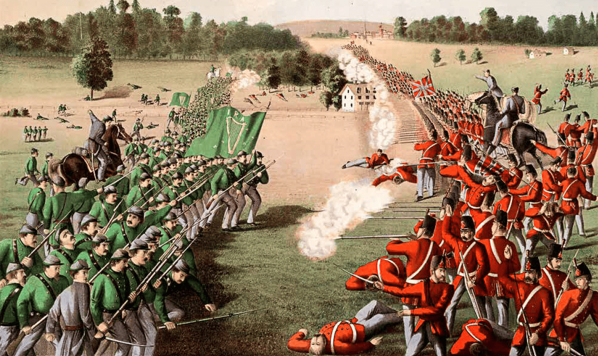 The charge of the Fenians at the Battle of Ridgeway, near Niagara, Canada West, on June 2, 1866. LAC.
Jack continues his look at local history by examining the threat posed by Americans over the years.
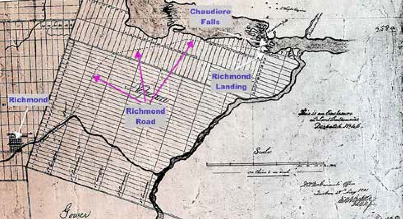 A contemporary map showing Richmond Landing and Richmond Road.
Jack Hanna shares the story of the Earl of Dalhousie, Captain LeBreton, and the shaping of the Rideau Canal:
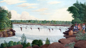
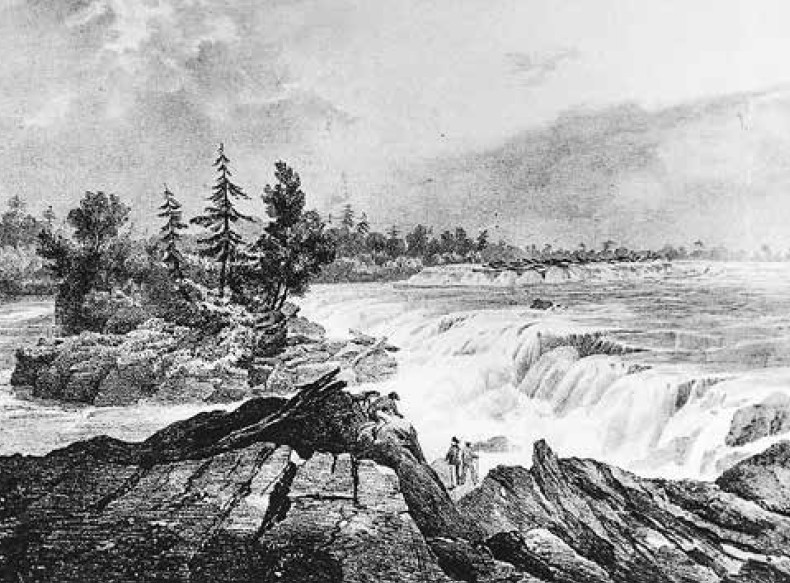 A drawing by Col. John By in 1826 of the Chaudiere Falls. (National Gallery of Canada).
Jack Hanna paints an intimate portrait of the legendary overseer of the Rideau Canal’s construction, Lt. Colonel John By.
Algonquin Anishinaabeg of the Ottawa River Valley: Yesterday, Today & Tomorrow
The year 2026 marks the 200th anniversary of the start of the Rideau Canal and Bytown – but how did this impact the Algonquin people, for whom the Ottawa Valley has been home for millennia?
Dr. Lynn Gehl makes the case that, two centuries later, we have yet to resolve crucial issues such as that our nation’s capital – the “heart of Canada” – continues to trespass on the traditional and unceded territory of the Algonquin Anishinaabeg and that the violation of Algonquin rights continues.
Additional links:
Website: www.lynngehl.com
Email: This email address is being protected from spambots. You need JavaScript enabled to view it.
Public social media: https://www.facebook.com/LynnGehlAlgonquin/
Speaking Agent: https://speakerscanada.com/keynote-speaker/dr-lynn-gehl/
The Truth that Wampum Tells: https://fernwoodpublishing.ca/book/the-truth-that-wampum-tells
Anishinaabeg Stories: https://www.amazon.ca/Anishinaabeg-Stories-Featuring-Petroglyphs-Petrographs/dp/0988157802
Claiming Anishinaabeg: https://uofrpress.ca/Books/C/Claiming-Anishinaabe
Gehl v Canada: https://uofrpress.ca/Books/G/Gehl-v-Canada
Policy Options: https://policyoptions.irpp.org/authors/lynn-gehl/
Briarpatch: https://briarpatchmagazine.com/contributors/view/gehl-lynn
Rabble: https://rabble.ca/author/lynn-gehl/
Canadian Dimension: https://canadiandimension.com/articles/author/lynn-gehl
Sentinel: https://watershedsentinel.ca/article/akikodjiwan/
The Gehl Report: https://www.lynngehl.com/indigenous-women-and-girls-with-disabilities-are-bigger-targets-of-sexual-violence.html
Albert Dumont – The Kettle of Boiling Waters: Chaudière Falls, Algonquin Territory
Algonquin elder Albert “South Wind” Dumont speaks of the immense spiritual significance of the Chaudière Falls, and cautions on the importance of decisions made regarding their future:
The Kettle of Boiling Waters: Chaudière Falls, Algonquin Territory
“Unceded” Land: Understanding the Historic Land Claims of the Anishinaabe Alqonquin People
When we acknowledge that, here in the Ottawa Valley, we are on the “unceded” and “unsurrendered” land of the Anishinaabe Algonquin people, what does that really mean?
A preliminary understanding of the history behind the land claims of the Anishinaabe Algonquin peopleis offered in a “Report on the Algonquins of Golden Lake Claim” prepared for the Ontario Native Affairs Secretariat in 1993.
The following is the text of the report’s “Executive Summary”.
Here is a link to the full report, residing on the Government of Canada website: https://publications.gc.ca/collections/collection_2018/aanc-inac/R32-492-1993-1-eng.pdf.
This report was authored by Joan Holmes & Associates, Inc. Joan Holmes has a Master’s Degree in Northern and Native Issues from the Institute of Indigenous and Canadian Studies at Carleton University (1983) and over the past 40 years has been widely called upon as an expert in the field of Indigenous land claims and litigation.
REPORT ON THE ALGONQUINS OF GOLDEN LAKE CLAIM
EXECUTIVE SUMMARY
Prepared by Joan Holmes & Associates, Inc. for Ontario Native Affairs Secretariat October 30, 1993
Peter Di Gangi – Algonquin Territory – Indigenous Title Yet Resolved
Peter Di Gangi, based in Ottawa, is an established expert on Indigenous historical, legal and cultural research, working with Indigenous communities for over 40 years.
Peter points out that the traditional territory of the Algonquin people has always included the Ottawa Valley and adjacent lands, straddling the border between what is now Quebec and Ontario, but unlike most of Ontario and the Prairies, Algonquin territory has never been dealt with by a land-sharing Treaty and Algonquin title continues to exist.
This article was published in Canada’s History: www.canadashistory.ca/explore/politics-law/algonquin-territory
Lynn Gehl – Akikodjiwan
Lynn Gehl, PhD, author, activist and member of the Algonquins of Pikwàkanagàn First Nation, makes the case, in this 2018 article, that historic and current development has betrayed the "Asinabka" vision of the late Chief William Commanda and desecrates what should alternatively be preserved and honoured as our nation's potential "heart of reconciliation":
The Chaudière Falls (Akikodjiwan) and surrounding landscape have long been a sacred place for Algonquin and other First Nations. How has this been impacted over the past two centuries, since the arrival of Europeans in the Ottawa area?
Has the historic and ongoing development of the Chaudière district (Chaudière Falls and Chaudiére, Albert, and Victoria Islands) been emblematic of our nation's disregard for Indigenous rights and jurisdiction?
Akikodjiwan - The Destruction of Canada’s Heart of Reconciliation
Prior to colonization, the Algonquin Anishinaabeg relied on the land and waterways now known as the provinces of Ontario and Quebec and the Ottawa River. Through the gifts they provided, the Algonquin achieved mino-pimadiziwin (the good life).
It was through Nanaboozo’s hardship of living without a father, his process of seeking revenge and learning forgiveness, that human beings understand reconciliation. The Spirit of the West Wind gave the First Sacred Pipe to his son Nanaboozo, instructing him about the rituals of reconciliation that include ceremony and prayer as the practices of reunion between father and son, peoples, and nations.
“During the historic treaty process British officials ignored the Algonquin because our very territory was becoming the heart of Canada.”
While many people think this Nanaboozo story is a romantic belief that lacks rationality, it is much more. Sacred beliefs that value the natural world are far more sustainable and intelligent than the destruction that manifests through the current economic paradigm, resulting in the polluting of our land and waterways with such things as plastic, sewage, chemicals, and radioactive particles.
During the historic treaty process British officials ignored the Algonquin because our very territory was becoming the heart of Canada. Through subjugating the Algonquin, the colonizers were able to appropriate Algonquin territory and centralize their Parliament base.
Many people today think Canada is in a better place with Indigenous nations. This is not so. Through the power gained from pilfering Indigenous land and water rights, Canada continues to divide the Algonquin through practices such as obfuscating and spinning what Canada’s treaty responsibilities are.
“In a world of economic power that lacks an understanding of the importance of preserving what is sacred, Algonquin jurisdiction and human rights continue to be pushed aside.”
Akikodjiwan and Akikpautik (Pipe Bowl Falls), located in the Ottawa River just upstream from Canada’s Parliament, are the very land and waterscapes where Creator placed the First Sacred Pipe. Through colonization Akikpautik was eventually dammed, and the islands that make up the larger Akikodjiwan landscape are now called Chaudière, Albert, and Victoria Islands. It was Grandfather William Commanda’s vision to have this sacred place restored. His Asinabka plan was endorsed and promised by many.
Unfortunately, despite Prime Minister Justin Trudeau’s rhetoric of respecting a “nation-to-nation” relationship and calling for “reconciliation,” the current Liberal government is permitting the further desecration of this sacred place. I offer here a timeline of the continued destruction of the ultimate place of reconciliation inscribed by Creator.
1613: Samuel de Champlain records the Anishinaabeg offering tobacco to Akikpautik (Pipe Bowl Falls), also called Asticou meaning “the boiler.” Champlain translates this as “Chaudière.”
1806: Philemon Wright’s lumber industry begins within Algonquin traditional territory in the Ottawa River Valley.
1854: The Government of the Province of Canada approves an Order-in-Council reserving the Chaudière Islands and adjacent area of the Ontario shoreline for public purposes.
1856: Leases are issued so the lumber industry can harness the water’s energy for their sawmills. These lots are on Chaudière, Albert, and Victoria Islands.
1880: J.R. Booth now holds most of the lease interests on the Islands.
1908: A large ring dam is constructed extending from Chaudière Island over the entire span of the falls. Eventually E.B. Eddy takes over its operation for pulp and paper manufacturing purposes.
1913: William Commanda is born and becomes a respected knowledge holder and Grandfather. Eventually he has a vision about re-naturalizing Chaudière Falls and the Islands. He wants the sacredness of Akikpautik returned to its natural form and the islands housed with a park, an Indigenous centre, and a peace-building meeting site for all peoples. He calls his plan “Asinabka.”
1936: Prime Minister Mackenzie King commissions Jacques Gréber to create a master plan that will govern the development of the National Capital Region.6 It was completed in 1950. Gréber concludes the most effective improvement will be the central park at the Chaudière Falls.
1958: The National Capital Commission (NCC) is established to implement Gréber’s Master Plan.
1969: The NCC purchases 40 per cent of E.B. Eddy’s operations. As a condition the NCC gains first call on E.B. Eddy’s remaining property.
1990: Plans are announced regarding an Indigenous Centre on Victoria Island.
1998: Grandfather Commanda consults with the NCC, Douglas Cardinal, Algonquin communities in the provinces of Ontario and Quebec, and Indigenous and non-Indigenous peoples regarding his Asinabka Plan.
Domtar purchases E.B. Eddy’s operations. This does not mean Domtar purchased the land and waterscape.
2003: Grandfather Commanda asks the NCC and Domtar to produce the deeds to the Islands; nothing materializes.
2004: The Ministry of Canadian Heritage grants Grandfather Commanda $50,000 to further conceptualize his Asinabka Plan.
2006: The NCC endorses Asinabka and allocates $35 million toward it.
Grandfather Commanda prophesizes, “It is a vision for the revitalization of this Sacred Site, Asinabka, at the circular Chaudière Rapids, Akikpautik: The Pipe Bowl Falls.”
Stephen Harper is elected as prime minister and opens the doors for corporate development in respect to the Islands.
2007: Domtar closes their paper mill operation.
2010: The City of Ottawa endorses Grandfather Commanda’s Asinabka Plan.
2011: With great sadness, Grandfather Commanda passes into the spirit world.
2012: Domtar places their interests up for sale. The NCC applies for funds but the treasury board refuses.
Canada permits the transfer of the Ring Dam to Energy Ottawa, a municipally owned power company.
2013: Windmill Development Group publicly announces interest in the Islands, discussing the need for re-zoning for their condominium and commercial development project.
2014: The Circle of All Nations reports that the Service Ontario Land Registry indicates Chaudière Island is not owned by Domtar.
Ottawa City council votes in favour of Windmill’s application to re-zone the islands from “parks and open space” to “downtown mixed use.”
Kitigan Zibi First Nation releases a statement: “Our traditional territory has always been and continues to be, Unceded. We hereby put Canada, Québec and Ontario on notice that [the] status quo, in which our Aboriginal title lands are taken up by governments and industry, is not acceptable.”
Douglas Cardinal, Romola V. Thumbadoo-Trebilcock, Richard Jackman, Larry McDermott, and Lindsay Lambert file an appeal to the Ontario Municipal Board (OMB) regarding the re-zoning.
2015: Windmill re-names their project as “Zibi.”21 Chief Gilbert Whiteduck argues the use of the Algonquin word is cultural appropriation.
May 2015: The City of Ottawa files a motion requesting the OMB dismiss the five appeals regarding the re-zoning due to a lack of planning grounds. This would result in the denial of a full hearing.
June 2015: The OMB pre-hearing begins with member Richard Makuch presiding.
August 2015: The Ottawa Citizen reports that Domtar sells their operations to Windmill. This involves land that Domtar has never proven they own.23 The Service Ontario Land Registry identifies Windmill as leasing the land from Domtar.
The OMB pre-hearing resumes. The appellants argue consultation is required, and that the re-zoning was a departure from the Gréber and Asinabka Plans.
The City and Windmill argue the appellants lack planning grounds, Chaudière Island is no longer an Indigenous cultural site of significance because of the industrial era, and all the land is in private hands. Wolf Lake, Timiskaming, Eagle Village, and Barriere Lake First Nations call for the protection of Akikodjiwan.
November 2015: Makuch dismisses the five appeals on the grounds that the re-zoning conforms to the City’s plan, the appellants failed to raise legitimate planning grounds. He also argues there was adequate consultation with Pikwàkanagàn First Nation and the organization known as the Algonquins of Ontario. In this way he imposes colonial provincial borders on the process of justice thus denying the rights of the larger Algonquin Nation that spans the Ottawa River and includes the Algonquin located in Quebec, both status and non-status Algonquin.
Justin Trudeau is sworn in as prime minister claiming to respect the “nation-to-nation relationship” and genuine “reconciliation.”
The Assembly of the First Nations of Québec and Labrador pass a resolution to protect Akikodjiwan.
Despite Algonquin and settler opposition, Energy Ottawa begins drilling a water channel deep into the bedrock of Chaudière Island27 for additional hydroelectric generation.
March 2016: The appellants appear in the Ontario Divisional Court (ODC) seeking leave to appeal the OMB decision. Justice Charles T. Hackland dismisses them on the grounds the OMB made no errors of law.
June 2016: In protest, more than five hundred people, both settler and Indigenous, walk from Victoria Island to Parliament Hill.
October 2016: Appellants appeal again to the ODC regarding Hackland’s dismissal. A panel of three judges denies the appellants.
December 2017: Although it is said the Tsilhoqot’in decision ushered in a new paradigm regarding Indigenous rights of consent versus consultations, on December 15, 2017, the Government of Canada approved a series of land transfers between the National Capital Commission, Public Services and Procurement Canada, the Ontario Ministry of Natural Resources and Forestry, and Windmill Dream Zibi for lands on islands in the Ottawa River. This happened without the consent of the larger Algonquin Nation, which includes the status and the non-status in both Quebec and Ontario.
February 2018: As of February 5th, 2018 the Service Ontario Land Registry assigns Windmill Dream Zibi Ontario Inc. parcels of land on Chaudière Island and Albert Island.
Contrary to what the City of Ottawa, Windmill Development, and the Ontario Municipal Board argued, the appellants rested their arguments on legitimate planning grounds: Jacques Gréber’s Master Plan and Grandfather William Commanda’s Asinabka Plan.
Both plans long pre-dated Windmill’s project, yet in a world of economic power that lacks an understanding of the importance of preserving what is sacred, Algonquin jurisdiction and human rights continue to be pushed aside. Clearly the Liberal government’s rhetoric of respecting a nation-to-nation relationship and seeking genuine reconciliation is a bold-faced lie.
Author Lynn Gehl © 2018, Lynn Gehl Ph.D. All rights reserved.
(Published in the Watershed Sentinel)
Reprinted with permission of the author.
Lynn Gehl, PhD., is a member of Pikwàkanagàn First Nation. She is the author of two books: 2014’s The Truth That Wampum Tells: My Debwewin on the Algonquin Land Claims Process with Fernwood Publishing; and 2017’s Claiming Anishinaabe: Decolonizing the Human Spirit with the University of Regina Press.
Here is a link to the full article: https://watershedsentinel.ca/articles/akikodjiwan/
Follow this link to view more of Lynn Gehl's work: www.lynngehl.com
Listen to the February 2026 HSO presentation with Lynn Gehl: Algonquin Anishinaabeg of the Ottawa River Valley: Yesterday Today Tomorrow
Dr. Gehl recommends these resources as further reading:
Matchewan, J-M. (1992, February 4). Algonquin Nation as Represented by Barriere Lake, Kipawa, Timiskaming and Wolf Lake. Retreived from https://publications.gc.ca/collections/collection_2018/aanc-inac/R5-648-1992-eng.pdf
Di Gangi, P. (2018, April 30). Algonquin Territory: Indigenous title to land in the Ottawa Valley is an issue that is yet to be resolved. Canada’s History. Retrieved from https://www.canadashistory.ca/explore/politics-law/algonquin-territory
Dumont, A. (South Wind). (2013, December 28). The Kettle of Boiling Waters: Chaudière Falls, Algonquin Territory. Albert Dumont.Retrieved from http://albertdumont.com/the-kettle-of-boiling-waters-chaudiere-falls-algonquin-territory/
Gehl, L. (2016, November 15). Deeply flawed process around Algonquin land claim agreement. Policy Options.Retrieved from https://policyoptions.irpp.org/magazines/november-2016/deeply-flawed-process-around-algonquin-land-claim-agreement/
Gehl, L. (2018b, March 8). Akikodjiwan: The Destruction of Canada’s Heart of Reconciliation. Watershed Sentinel. Retrieved from https://watershedsentinel.ca/articles/akikodjiwan/
Huitema, M.E. (2000). “Land of Which the Savages Stood in no Particular Need”: Dispossessing the Algonquins of South-Eastern Ontario of Their Lands, 1760-1930 . Master of Arts thesis, Queen’s University, Kingston, ON. Retrieved from https://iportal.usask.ca/record/6234
Jury, E.M. (1966). Tessouat (Besouat); Tessouat (Le Borgne de l’Île); Tessouat (Tesswehas, Le Borgne de l’Île) Paul. Dictionary of Canadian Biography (Vol. 1) (pp. 638-641). Toronto: University of Toronto Press. Here they are online.
- https://www.biographi.ca/en/bio/tessouat_1603_13_1E.html
- https://www.biographi.ca/en/bio/tessouat_1636_1E.html
- https://www.biographi.ca/en/bio/tessouat_1654_1E.html
Matchewan, N. (2008). Blockades: Algonquins of Barriere Lake Defend the Forest, 1989-2008. In First Nations Strategic Bulletin. Volume 6, Issue 1, September – October 2008. (pp. 28-29). Retrieved from https://epe.lac-bac.gc.ca/100/201/300/first_nations_strategic_bulletin/2008/v06n02.pdf
Pasternak, S. (2009, October 26). They’re Clear Cutting Our Way of Life: Algonquins Defend the Forest. Upping the Anti. Retrieved from https://uppingtheanti.org/journal/article/08-theyre-clear-cutting-our-way-of-life/
Pugliese, K. (2005). ‘So, where are you from?’ Glimpsing the history of Ottawa-Gatineau’s Urban Indian Communities. Master’s thesis, Carleton University, Ottawa, ON. Retrieved from https://repository.library.carleton.ca/concern/etds/0v838113m
Sarazin, G (1992). 220 Years of Broken Promises. In B. Richardson (Ed.), Drumbeat: anger and renewal in Indian country (pp. 167-200). Toronto: Summerhill Press. (original work published 1989)
Whiteduck, K. (2009). Our Majestic Forests: An Aboriginal View of Algonquin Park. In D. Euler & M. Wilton (Eds.), Algonquin Park: The Human Impact (pp. 36-54). Espanola, ON: OJ Graphix Inc.
http://www.asinabka.com/geninfo.htm
https://qshare.queensu.ca/Users01/gordond/planningcanadascapital/greber1950/
https://ricochet.media/en/101/ottawa-city-council-approves-rezoning-sacred-algonquin-site
http://rabble.ca/news/2016/06/condominium-development-threatens-protection-algonquin-sacred-site
James Powell – The Anishinabek
James Powell is the author of the blog Today in Ottawa's History giving a day-by-day account of local history.
The Anishinabek
For thousands of years before the Rideau Canal and Bytown, the Ottawa Valley was home to the Anishinaabe Algonquin people and remains their unceded land. James Powell explores the story of the Algonquin people and the devastating impact that European settlement had on their lives and livelihoods: The Anishinabek, Time Immemorial, 7 October 1783
Going Up the Dumoine
Part One: Pre-Logging
The Kichi Sipi, also known as the Ottawa River, is the thirteenth longest river in Canada. The rivers’ one hundred and forty-six thousand square miles watershed is bisected by the Sibi’s serpentine route as it curls back on itself going west from its source north of Ottawa, then heading southeast from Lake Témiscamingue to the St Lawrence River. It is the traditional unceded territory of the Anishinabe-Algonquin Nation. From the interior, sixteen major tributaries flow from various large headwater lakes to form multiple access routes into the watershed. The only major tributary to have never been dammed, settled, or industrialized save for logging, is the Dumoine. It is now protected as a Quebec aquatic reserve (2008) along with the Coulonge and Noire (2023).
The Kichi Sibi is the watershed that defined the Anishinabe-Algonquin history for time immemorial. Groups of Anishinabe families separately identified themselves as unified self-regulating custodians for ‘their tributary . ’ Together they all formed the Anishinabe-Algonquin Nation. Each family (10-20 related individuals) was assigned approximately a thousand square mile hunting territory, orally defined using natural feature boundaries, and protected by customary law. The Dumoine was a popular route for other nations to cross the Algonquin territory. The Dumoine families, of course, used it frequently to paddle to Algonquin rendezvous for social events. These events were centred on trade, religion, and customary law. The summer wanderings of the families were focused on seasonal harvesting of spawning fish and eels, birds migrating, maturing of fruit, vegetable and medicinal plants, and the gathering of raw materials. These materials were used for creating canoes, hunting and cooking tools, clothing, footwear, dwellings, baskets, and infant cradles. All these goods were often decorated with impressive artwork. The Dumoine group of families, known first to the Jesuits and Champlain as the Otaguottouemin, were identified two centuries later in government documents as the Dumoine Band. Their story is typical of those Algonquins that lived for centuries along the major tributaries.
Long before the Europeans arrived, the Dumoine Band maintained a lifestyle that involved wintering in their designated hunting territories while hunting and trapping. They used the paddling season for travelling throughout the watershed. The chiefs endorsed a few adventuresome individuals to participate in war or trade missions further afield. A wide variety of other First Nations traders brought goods to these families, most often at the trading site at the mouth of the Dumoine. These goods originated from the Mississippi watershed, the Great Lakes, the James Bay, and the Atlantic Ocean, so a variety of food, goods, and cultural ideas penetrated the interior long before the first white man arrived.
The mouth of Dumoine featured a long sandy spit that rose gracefully up into the pine forest as a grass-covered gravel bar capable of growing root crops. It formed a perfect camping and trading site. The Wolf Lake elders (2022), the direct descendants of the Dumoine families, shared with us the name Akonakwasi for this site meaning ‘a long stretch of sand extending far away’ adding Sakik for the mouth and Sibi for the river (now underwater since the Rapides des Joachims dam was built in 1950).
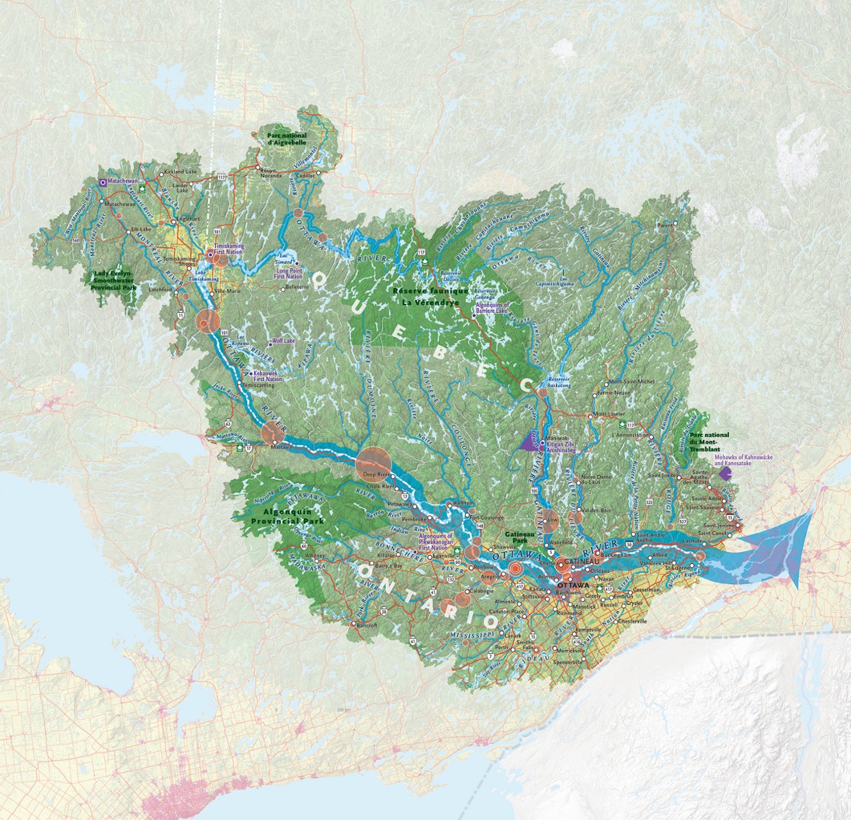 Canadian Geographic map of Ottawa River Watershed.
It is a challenging four day paddle up the Dumoine which rises one hundred vertical feet as falls, chutes and rapids from the mouth to Lac Dumoine. The creation of magnificent Lac Dumoine is as difficult to imagine being done by a retreating glacier, carving out this eighty-one square mile lake as it is to imagine Nenabojo (also known as Wiske’djak the Anishinabe trickster) chasing a giant beaver out of the south end churning up the land and forming the Dumoine River in the process. But both are accepted stories in different cultures. Lac Dumoine (Anishinabe name is Keewagama one of the many accepted spellings) is unique for four long outlets stretching in each cardinal direction and with a river entering or exiting each. It is a natural traffic circle and has served as an important crossroads for trade and travel since the melting glacier filled it.
French explorer, Samuel de Champlain, was one of the first white men to travel the Kichi Sibi in 1613, preceded by his youthful emissaries Étienne Brûlé and Nicholas de Vignau (1611). Some Anishinabe met white men earlier (i.e. Champlain in Tadoussac in 1603) on their travels outside the watershed. Priests often accompanied Champlain and his emissaries, reflecting that their mission to convert Algonquins (and also exploration) was a priority from France. Champlain himself functioned as both an explorer and soldier, representing New France as an ally of the Algonquins and Hurons against the Iroquois.
Prior to contact with the Europeans, the Algonquin economy had centred on trading furs, dried foods, and hand-crafted products, like birch-bark canoes and other practical implements. After contact, the focus on trade changed to European manufactured goods for furs. From 1620-1700 the Iroquois (Haudensaunee) Confederacy attacked the region of the Kichi Sipi because of their desire to influence the beaver fur trade south to their territory. They sent their warriors north to control the Kichi Sibi trade with attacks originating along many of the major portages along the Ottawa River and as far north as the James Bay height of land. It was tributaries like the Dumoine that provided detours north then east to the French trade centres of Montreal and Trois-Rivières for those trying to avoid the Iroquois. Beginning in 1670 (Royal Charter), the new Hudson's Bay Company was attracting Cree and Anishinabe fur traders north to James Bay. In 1686, to protect the business interests of the merchants of New France, Pierre Le Moyne, Chevalier de Troyes d`Iberville, with the assistance of Anishinabe guides, led French Marines from Montreal up the Ottawa River to attack the British posts on James Bay.
The European trade and the Catholic religion influenced the Dumoine family life by the 1600s. Trade brought metal tools, pots, traps, firearms, woollen blankets and clothing, and other luxuries into the family unit. It also brought disease and alcohol. The Black Robes (Recollects, Jesuits, Sulpicians and finally the Oblates) brought Catholicism to the Algonquins. Being a Catholic (approximately half the Anishinabe population converted) required an annual pilgrimage to the Sulpician mission at Oka near Montreal to be properly baptized, married, or buried as a Catholic. However, beginning in the 1830s, the Oblates built mission churches closer to the Dumoine beside Hudson’s Bay Company posts located at Fort William, Fort Témiscamingue and Fort Grand Lac Victoria, resulting in the elimination of this pilgrimage. The route to the mission at Grand Lac Victoria was up the Dumoine from the Kichi Sibi. Oblate priests, guided by Algonquins may have named the river ‘the river the monks travel.’ This was translated onto maps as Rivière du Moine (Hawkins 1836) and later map makers anglicized this to the Dumoine River.
There were temporary trading posts set up at the Dumoine each spring. Starting with trading posts that independent traders set up in the 1700s, followed by the Northwest Company from 1790-1820, and finally the Hudson’s Bay Company, whose trading posts lasted from 1821 to 1840.
Lumberjacks mixed their French, Irish and English accents together to create the unique phrase for travelling to their new workplace “Going Up da Dumun.” Roderick Ryan was the first lumber baron who used the mouth as a base for his operations for travelling upriver circa 1840. He and John Egan lead an invasion of a new type of economy away from furs and at the expense of the Algonquin Dumoine family way of life. The story of Roderick Ryan and John Egan will be shared in Part Two this blog.
Wallace A Schaber
I am not a professional historian or Anishinabe expert. I am a collector of maps, stories, and artifacts about the Dumoine based on fifty years of guiding there by canoe, ski, and foot. Many of these stories are found in my book, Last of the Wild Rivers (2016), which is out of print but available as an e-book online.
Friends of the Dumoine
In 2016, concerned Dumoine guides and travellers formed Friends of Dumoine to keep the rivers portages and campsites clean.
Mission Statement
“To champion conservation of the Dumoine watershed, promote non- mechanized recreation and strengthen knowledge of its natural environment and human history.”
Our major achievement to date is the re-opening and interpretation of the old Anishinabe portages that existed for centuries and linking them to the Dumoine tote road used by the lumber industry beginning in 1840. This hiking trail is now open from the Ottawa River to Grande Chute as a twenty-six kilometre hiking-skiing trail www.sentierdumoine.ca. A visitor centre at Grande Chute complete with historic maps and artifacts is located at the northern gateway.
Please join us on the trail or virtually online to explore Canada's history and protect it. For more information about how to volunteer or donate write This email address is being protected from spambots. You need JavaScript enabled to view it..
Friends of the Dumoine would like to thank our partners in helping to make this project a reality.
CPAWS Ottawa Valley
ZEC Dumoine
Wolf Lake First Nation
References and Further Reading
Fournier, J-L. Anishinabe Place Names for the Dumoine Hiking Trail, confirmed and sanctioned by Wolf Lake First Nation, May 2022. Prepared for Friends of Dumoine Trail Map published 2024.
Morrison, James. “Algonquin History in the Ottawa River Watershed.” Sicani Research & Advisory Services Ottawa, Ontario, Revised 2005.
Frank G. Speck. “Myths and Folklore of the Timiskaming Algonquin and the Timagami Ojibwa.” Canada Department of Mines. Geological Survey, Memoir 71, No 9 Anthropological Series. Ottawa: Government Printing Bureau, (1915):1-3.
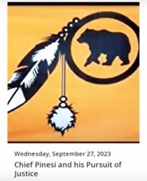
Chief Pinesi and his Pursuit of Justice
Our first virtual speaker session of the year was held on September 27, 2023, and featured a pre-recorded presentation by Jim Stone, supported by Merv Sarazin who introduced Jim and remained with the presentation to answer questions and provide additional background. Jim, a retired Foreign Service officer and amateur historian, focussed his presentation on the life of Grand Chief Pierre Louis Constant Pinesi (1768 – 1834) and the turbulent times in which he lived. Jim also provided a more general history of the Alongkin* peoples of the Ottawa area in the 150 years or so prior to Chief Pinesi’s birth. Jim is not Indigenous himself and assembled the information for his presentation from published and archival sources, not traditional Alongkin knowledge, though he has consulted with the people of Pikwakanagan First Nation where a number of Chief Pinesi’s descendants live.
Jim described that, starting in the early 1600s, things began to go badly for the Alongkin people of the Ottawa valley. They were ravaged by a series of European diseases and their consequences. Later, they were driven from their lands by the Iroquois who were expanding their territory. As a result, the Ottawa valley became nearly depopulated. It was not until the signing of the Grand Peace of 1701 between the French, Alongkin, Iroquois and others, that the Alongkin began to return to this area.
Jim explained that prior to the influx of settlers, Alongkin family hunting grounds were fairly fixed and well respected. Chief Pinesi described his hunting grounds as being south of the Ottawa River, centered on the Rideau River. The exact boundaries, which would have followed natural land forms, are today unknown. Based on a meeting documented by Philemon Wright that he had with two Chiefs who were protesting his logging activities, it is possible that Chief Pinesi had some access to or use of lands to the north of the Ottawa River. Chief Pinesi and his family, he had 12 children, many of whom died young, would have travelled widely in his hunting grounds. He would also have travelled throughout the greater territory, especially to the Lake of Two Mountains, now Oka, where there was a summer gathering of Alongkin, Nipissing and Mohawk peoples, along with a French Catholic Mission.
Just prior to the 1800s, settlers began arriving in the Ottawa watershed. This resulted from the British domination of North America established by the Treaty of Paris in 1763 and spurred on by the American Revolution, which ended in 1783. Loggers cleared the forests, destroying the habitat of the animals hunted by the Alongkin, and settlers divided the land for farming. Both groups also competed for the same fish and animals that fed Chief Pinesi, his family and the other Alongkin people. Construction of the Rideau Canal was especially devastating. The dams required for the waterway, such as at Hog’s Back, transformed the river into a series of essentially long lakes, destroying fishing grounds at the base of rapids and flooding traditional camping and cultural sites along the shores and on its islands. The large workforce also accessed the same natural food sources, driving some species to near extinction in the area.
Chief Pinesi and four of his sons were among the many Indigenous warriors, Alongkin, Nipissing and Iroquois, who fought with the British in the war of 1812. Indigenous warriors are known to have fought at Queenston (October 13, 1812), Odeltown (August 19, 1812), Chateauguay (October 26, 1813) and Beaver Dams (June 24, 1813). Alongkin and Nipissing warriors were prominent in the capture of Colonel Boerstler's Detachment of 512 US soldiers at Beaver Dams. Jim emphasized that these warriors fought as allies, not as soldiers of the British army. Merv Sarazin commented that had it not been for the impact of Indigenous warriors, Canada as we know it might not exist, having fallen to the Americans at that time.
Jim pointed out that much of Chief Pinesi’s life was dedicated to attempting to protect his people’s rights to their ancestral lands and to their way of life. He submitted about 20 petitions, in conjunction with other Alongkin and Nipissing Chiefs, to the governments of Upper and Lower Canada seeking their acknowledgement to Alongkin title to their lands, compensation for lands already lost to settlers, and restrictions on further settlement. The governments did not act upon these petitions, despite the observation by Chief Pineisi that the Alongkins had helped defend the British interest in the area. In 1819, in response to pressure from the increasing number of settlers, the government of Upper Canada signed a treaty with Mississauga Chiefs that included the Alongkin lands of the Rideau River watershed, including Chief Pinesi’s family hunting grounds. No treaty for land compensation was ever signed with the Alongkin.
Chief Pinesi and his wife both died in August 1834 as a result of a Cholera epidemic that was sweeping Upper and Lower Canada. Jim believes that they are buried in the second Catholic cemetery at Lake of Two Mountains, though no record of the exact location of these graves survives.
You can watch Jim’s full presentation on the HSO YouTube channel.
A more complete written version of Jim’s work with footnotes can be downloaded from Grand Chief Constant Pinesi – Kichi Sibi Trails (kichisibiancienttrails.ca) .
Additional, Merv Sarazin referred to the book “The Ancestors are Arranging Things”, by Noreen Kruzich, available for purchase online or from the Ottawa Public Library.
*The term “Algonkin” is used to refer to the Anishinabeg living in the land claimed by Chief Pinesi on both sides of the Ottawa River and all its tributaries from Oka to Mattawa, including the headwaters of the latter river. The term Algonquin refers to a much larger group of Indigenous people. This term parallels that used by Noreen Kruzich in her book "The Ancestors are Arranging Things".
Quick Links
About
Supporting Partners