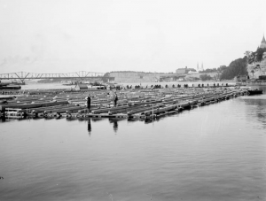
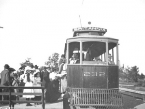
Since September 2020, the Historical Society of Ottawa has presented a virtual speakers series using Zoom. A full recording of those presentations is available on the HSO YouTube channel and shown here as well.
The Historical Society of Ottawa does not necessarily subscribe to views expressed in these videos, nor take any responsibility for their content.
The Chaudière Bridges
28 September 1826
Bridges are amazing structures. Spanning rivers, gorges, bays and even open ocean, they are testaments to the ingenuity of the engineers who designed them and the courage and ability of the workers who constructed them. Who hasn’t crossed a bridge and wondered what’s holding it up and experienced a frisson of excitement or even terror? The longest bridge in the world over water connects Hong Kong to Macau and the city of Zhuhai on the Chinese mainland, a distance of 55 kilometres, of which a 6.7-kilometre stretch midway is an under-water tunnel between two artificial islands to allow ocean-going ships to travel up the Pearl River estuary. It opened in 2018. Canada’s Confederation Bridge, which links Prince Edward Island to New Brunswick, is 12.9 kilometres long. At the other extreme is Bermuda’s Somerset Bridge that connects Somerset Island with the “mainland.” Dating back to 1620, it is reputedly the smallest drawbridge in the world. Operated by hand, it is just wide enough to allow a mast of a sailboat travelling between the Great Sound and Ely’s Harbour to pass through the gap.
In Canada’s capital, six bridges span the mighty Ottawa River: the Alexandra (or Interprovincial) Bridge; the Champlain Bridge; the Chaudière Bridge; the Macdonald-Cartier Bridge; the Portage Bridge; and the Prince of Wales Bridge (now closed). While the current Chaudière Bridge dates from 1919, it is the site of the first and for a long time the only bridge across the Ottawa River.
The need for a bridge crossing the Ottawa River became apparent after work commenced on the Rideau Canal in the summer of 1826 under the direction of Lieutenant Colonel John By of the Royal Engineers. With only wilderness on the Upper Canada side, workers and supplies had to be ferried across the river from Wright’s Town (later known as Hull) in Lower Canada, the only settlement of any consequence in the region, where labourers were billeted and shops and stores could be had. (American Philemon Wright had founded Wright’s Town in 1804.) As this was unsatisfactory to all, Colonel By and his engineering colleagues decided to build a bridge as quickly as possible, their haste probably encouraged by the approach of winter.
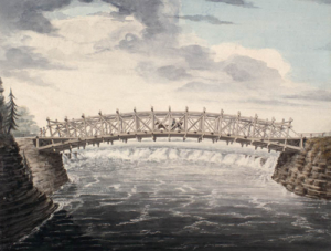
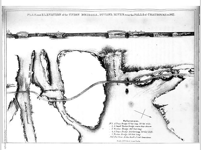 Plan and Elevation of the Union Bridge in Joseph Bouchette, The British Dominions in North America, London, 1832.
Their plan was to build a series of bridges to link Lower Canada on the northern shore of the Ottawa River to Upper Canada on the southern shore at the Chaudière Falls where the river temporarily narrows, using the islands mid-river as stepping stones. All were to be made of stone and masonry except for the widest section which was to be made of wood given the width of the gap, the depth of the water and the speed of the current. Col. By later modified this plan. Five of the seven bridges were made of wood—(from south to north over the river,) a 117-foot truss bridge, a small bridge over a deep chasm, a 160-foot bridge, a 212-foot truss bridge, a 180-foot bridge, and two limestone bridges.
After a quick survey—these were the days long before environmental assessments—construction began. On 28 September 1826, General George Ramsay, 9th Earl Dalhousie and Governor General of British North America, placed several George IV silver coins under a foundation stone on the Lower Canadian shore. Colonel Durnford of the Royal Engineers, Colonel John By, and a number of prominent area landowners, including Nicholas Sparks, Thomas McKay and Philemon Wright, attended the ceremony.
Three weeks into the construction, the first masonry arch on the Lower Canada side collapsed when the temporary supporting falsework was removed. Colonel By ordered work to recommence immediately with new plans drawn up by Thomas Burrowes, the assistant overseer of works. The new, hammered stone arch was completed by early January 1827 despite atrocious working conditions. Spray from the nearby falls froze thickly onto the workers’ clothes despite rough wooden screens being installed to shelter them. The second arch was finished by the summer of 1827.
The biggest challenge was bridging the Chaudière itself, also known in English as the Giant Kettle. To link its two sides, Captain Asterbrooks of the Royal Artillery fired a brass cannon loaded with a ½-inch rope to workmen on Chaudière Island. Twice he failed, the rope breaking. But he succeeded with a 1-inch rope. Once workers had a hold of it, they were able to haul over larger cables. Two ten-foot wooden trestles were constructed on either side with ropes stretched over their top and fastened to the rocks. The workers fashioned a precarious footbridge with a rope handrail. It swayed in the wind and sagged to within seven feet of the raging torrent beneath it. It must have been terrifying to cross. In his 1832 book The British Dominions in North America, Joseph Bouchette wrote: “We cannot forebear associating with our recollections of this picturesque bridge the heroism of a distinguished peeress [Countess Dalhousie], who we believe, was the first woman to venture across it.” The bridge’s ropes were then replaced with stronger chains. But as workmen were planking the floor of the bridge, the last step in its construction, disaster struck. First one then the other chain broke, throwing men and their equipment into the raging torrent. While accounts vary, as many as three men drowned.
Undeterred by the tragedy, Colonel By immediately got back to work. This time, workmen constructed stronger trestles and bridged the gap with two 8-inch link chain cables. Two large scows, a type of flat-bottomed boat, were built and moored securely in the location of the bridge. Jack screws placed on the scows supported the bridge during its construction. Unbelievably, just prior to the bridge’s completion, a strong gale flipped it over. Workmen were obliged to cut the bridge free which sent it sailing down the Ottawa river, coming to land close to the entrance of the Rideau Canal. Reportedly, the Chief workman, Mr. Drummond, shed tears in frustration.
Again, Colonel By persevered; his next bridge held. Supported by chains made of 1 3/4-inch thick iron and 10-inch links, the wooden bridge was 212 feet long, 30 feet wide and roughly 40 feet above the water, high enough to escape damage during the spring freshet. It was completed in the summer of 1828, two years after construction had commenced. Upper and Lower Canada were finally united. Fittingly, Col. By called it the Union Bridge.
Lieutenant Pooley, who worked for Col. By, supervised the construction of a final bridge needed to connect Bytown with the new Union Bridge. This bridge spanned a “gully” in what became LeBreton Flats. So impressed was Col. By with Pooley’s round-log bridge that he dubbed it “Pooley’s Bridge.” This name stuck. Lieutenant Pooley’s wooden bridge was replaced by a stone bridge in 1873. It was designated a heritage structure in 1982.
As the Union Bridge was funded by the Imperial Government, Colonel By instituted a toll to help pay for it. The cost was one penny per person, one penny for every horse, ox, cow, sheep and pig, and two pennies for every wagon and sleigh. This was a pretty steep tariff for the times.
Sadly, the Union Bridge did not last. In May 1836, it collapsed into the river and was swept away. Fortunately, there was nobody on it at the time. Again, the only way across the Ottawa River was by ferry.
This all changed in 1843 when the Union Suspension Bridge, constructed by Mr. Wilkinson, an American, opened for traffic. The bridge had a span of 242 feet. Its iron wire suspension cables, which were imported from Britain to Montreal and ferried to Bytown in barges, supported an oaken plank deck. It was the first of its kind in Canada, and was considered an engineering marvel of the age. The Packet opined that the bridge was “a beautiful piece of work” and that it “reflects great credit to the builder, Mr. Wilkinson.” A big celebration was held at Doran’s Hotel on Wellington Street to mark its opening. Engraved invitations were sent out to guests to attend the “Union Suspension Bridge Ball,” complete with a picture of the completed bridge.
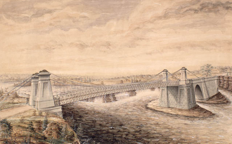 Union Suspension Bridge, Watercolour by F. P. Rubidge, Library and Archives Canada, Arch. Ref. R182-2.
Like its predecessor, the Union Suspension Bridge charged tolls. It was a profitable business. In the June to September period of 1851, Duncan Graham, appointed the (tax) Collector for Bytown in the Finance Department by Earl Cathcart, collected £303. 6s. 7d. (equivalent to more than $1,650) in tolls. This was almost enough to cover his annual salary of $1,500 and the monthly stipend £6. 5s. of Mr Mossop, the bridge keeper, who lived in the toll house rent free. Later, the government put the toll business out to tender. At the 1869 tender, the government set a reserve price of $2,000. This compares with annual tolls collected in the 1865-1868 period ranging from $2,500 to $3,350. The winner of the auction was required to maintain the toll house, and keep the bridge clean of rubbish. In winter, they were also responsible for snow clearance, but were required to leave six inches to facilitate sleigh traffic.
Bridge maintenance was not up to everybody’s standards. People complained that the bridge was dangerous especially at night as its railings were low and weak. “Persons run a very great risk on a dark night of driving into the ‘Devil’s Punch-bowl’” said the Ottawa Citizen. As well, the approaches to the bridge on either side of the river were nearly impassable during rainy weather owing to “the enormous quantity of mud and water collected.” In an agreement with the City, the Dominion government abolished tolls on the Union Suspension Bridge in 1885.
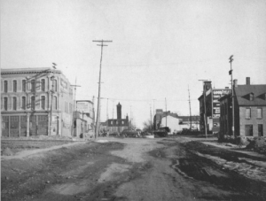
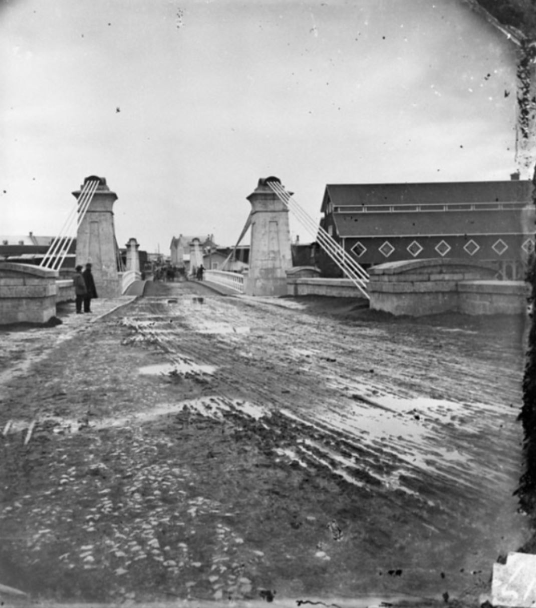 The muddy and rutted entrance to the Union Suspension Bridge, looking towards Ottawa, Topley Studio, c. 1867-70, Library and Archives Canada, PA-012705.In 1889, the Dominion government appropriated $35,000 for a new iron truss bridge to replace the deteriorating Union Suspension Bridge. Messrs. Rousseau & Mather were the contractors. Work commenced at the beginning of August and was completed by the beginning of December of that year. Many were concerned that the 30-foot width of the new roadway was too narrow given the growing amount of traffic between Ottawa and Hull. Appeals to the government to widen the bridge or at least put the two 5-foot sidewalks on the outside of the trestles in order to increase the width of the roadway by 10 feet fell on deaf ears.
Twelve years later in 1900, the Great Fire, which destroyed much of Hull and LeBreton Flats, severely damaged the bridge. A vital thoroughfare, the government moved quickly to repair it.
In 1919, the Government condemned the Chaudière bridge as being unsafe. According to the Citizen, just walking over the old bridge was enough to give one “thrills” owing to its “see-saw motion when cars pass over it.” Dominion policemen ensured that too many vehicles didn’t try to cross the bridge at the same time. The replacement bridge was built by the Dominion Bridge Company at a cost of $110,000. It was assembled on the Quebec side and was moved into place using scows. This time, government listened to its critics, and placed the sidewalks on the outside of the piers. Before the new Chaudière bridge was put into position, the old bridge was lifted by four 50-ton hydraulic jacks, placed on rollers, and moved 50 feet downriver to a temporary location so that traffic across the river would not be unduly impeded by the construction.
In 2008, the Chaudière bridge was temporarily closed when an inspection revealed that its stone arches, some of which date back to that first 1820’s bridge, were no longer safe. Following repairs, the government reopened the bridge the following year. It continues to serve thousands of commuters every day.
Sources:
Bouchette, Joseph, 1832. The British Dominions in North America, Vol. 1, London: Longman, Rees, Orme, Brown, Green and Longman.
Bytown Gazette, 1846. “No title,” 14 September.
Canada, Province of, 1867. Report of the Minister of Agriculture for 1866, Ottawa: Hunter, Rose & Company.
Mika, Nick & Helma, 1982. Bytown, The early day of Ottawa, Belleville: Mika Publishing Company.
Ottawa Citizen, 1868. “Editorial,” 19 June.
——————, 1869. “Tolls on Union Suspension Bridge,” 26 July.
——————, 1908. “Civil Servants’ Income Tax,” 17 February.
——————, 1919. “Chaudiere Bridge Gives One Thrills,” 18 August.
——————, 1919. “Are Moving The Old Chaudiere Bridge,” 21 August.
——————, 1929. “Ottawa’s First Bridge And Other Narrations,” 12 October.
——————, 1933. “Chaudiere Toll Bridge 1851, Document Tells of Revenue,” 5 August.
——————, 1981. “By-Gone Days,” 28 February.
Ottawa Journal, 1889,” Supplementary Estimates,” 24 April.
——————, 1889. “The Chaudiere Bridge,” 19 September.
Packet (The), 1847. “The Ottawa-Slides-Steamers-Railroads-Necessary Improvements, etc.” 12 June.
Story written by James Powell, the author of the blog Today in Ottawa's History.
Retired from the Bank of Canada, James is the author or co-author of three books dealing with some aspect of Canadian history. These comprise: A History of the Canadian Dollar, 2005, Bank of Canada, The Bank of Canada of James Elliott Coyne: Challenges, Confrontation and Change,” 2009, Queen’s University Press, and with Jill Moxley, Faking It! A History of Counterfeiting in Canada, 2013, General Store Publishing House, Renfrew, Ontario. James is a Director of The Historical Society of Ottawa.
Andrew King: What’s Ottawa Hiding?
The Historical Society of Ottawa went underground for our March 10th presentation, following author Andrew King on a journey to some of the hidden secrets of Ottawa’s past.
In 2019, Andrew wrote Ottawa Rewind: A Book of Curios and Mysteries. This was a collection of stories Andrew had written individually for local publications, about lesser-known people, places and events in Ottawa’s past. He followed this book up recently with Ottawa Rewind 2: More Curios and Mysteries, which takes a more “in-depth” look at the city beneath our feet.
One of Andrew’s earliest investigations lead to historic Pooley’s Bridge in search of a cave. Years earlier some girls had found the cave by accident, entered and followed the dark path about 150 feet before turning back in a panic after hearing what seemed to be the sound of mournful organ music.
Other secret passages are not so hard to find. One of the more curious of these is in plain sight, near the steps that lead from the Rideau Canal locks up to Parliament Hill.
Andrew not only searched for the location of the city’s many hidden tunnels, passageways and “subterranean secrets”, he mapped them out in 3D to help us better visualize where these mysterious place are; in case you’re interested in following Andrew’s path of research. Or, if you’d rather play it safe, watch the video of Andrew’s presentation and let him tell you his stories.
Ottawa's Subterranean Secrets
On March 10, 2021, Andrew King, Ottawa artist, cartoonist, columnist, and author of the Ottawa Rewind books and blog, shared some of his discoveries of long-hidden secrets from Ottawa's fascinating past.
Kettle Island: A Bridge to Ottawa's Past by Randy Boswell
If you missed our virtual Speaker Series presentation "Kettle Island: A Bridge to Ottawa's Past" with Randy Boswell, or you'd just like to watch it again, you can view this presentation online.
Here's a link to the recorded video of Randy's talk. Enjoy!
Ottawa the Beautiful: The Gréber Report
18 November 1949
Ottawa is undoubtedly a beautiful city. Blessed by geography, the city borders the mighty Ottawa River, and is bisected by the Rideau River and the Rideau Canal, one of only eight UNESCO world heritage sites in Canada. Reputedly, Ottawa has 8 hectares (20 acres) of parklands for every 1,000 residents, compared to only 3.2 hectares (8 acres) of green space for every 1,000 Toronto residents, and a miniscule 1.2 hectares (3 acres) for every 1,000 Montréalais. And that’s not counting Gatineau Park that encompasses 361 square kilometres (139 square miles) of rolling hills and pristine lakes, and extends close to the centre of Gatineau, Quebec, just a few minutes’ drive from Parliament Hill.
Befitting a capital city, Ottawa can also boast magnificent governmental, cultural, and historic buildings and monuments. The National Capital Commission’s “Confederation Boulevard,” which is bordered with broad, tree-line sidewalks, runs along Sussex Drive and down Wellington Street before looping across the Ottawa River and along rue Laurier in Gatineau before returning to Ottawa. On this ceremonial route, one can find the stately homes of the Governor General and the Prime Minister, Canada’s National Gallery, the War Memorial, the storied Château Laurier Hotel, and the Canadian Museum of History. Of course, the crown jewels of the route are Canada’s iconic Gothic Revival Parliament buildings on Wellington Street, perched on a bluff overlooking the Ottawa River.
While a beautiful and extremely livable city, Ottawa is not without blemish. Sparks Street, once the commercial heart of the city, hardly beats these days, while parts of Bank and Rideau Streets are tired and shop-worn. And let’s not talk about LeBreton Flats. But Ottawa is redeemed by its parks and gardens, flourishing neighbourhood communities, thriving markets, and leafy parkways that border its waterways.
Not that long ago, however, Ottawa was a grim, dirty, industrial town; crumbling buildings and blighted neighbourhoods were but a short distance of the Parliament buildings. During World War II, most of the downtown green spaces was filled with “temporary” wooden office buildings hastily constructed to house the Capital’s burgeoning civil service. The city’s natural beauty was also threatened with unplanned urban sprawl, while its waterways were fouled by the detritus of the area’s extensive wood-products industry and the untreated sewage of its mushrooming population.
Efforts to improve the city began shortly after Confederation with the creation of Major’s Hill Park in 1874. In 1899, three years after Prime Minister Sir Wilfrid Laurier voiced his desire for Ottawa to become the “Washington of the North,” the first city improvement committee called the Ottawa Improvement Commission (later the Federal District Commission) initiated a number of landscaping projects, including the Rideau Canal Driveway. A series of urban planning studies were subsequently commissioned, including the Todd Report in 1903, the Holt Commission in 1915, and the Cauchon Report in 1922. Their recommendations included an expansion of Ottawa parklands, the rationalization of the city’s tangle of railway lines, and the enforcement of building regulations. Broadly speaking, however, little was achieved owing to changing government priorities, war, and the Great Depression. One idea that initially found traction but ultimately also failed was the suggestion of forming a National Capital District, akin to the District of Columbia in the United States, that would encompass the cities of Ottawa in Ontario and Hull in Quebec, along with their hinterlands. Political opposition, notably from Quebec, and concerns about the linguistic future of the area’s francophone residents scuppered the idea.
Another effort at rejuvenating Ottawa’s downtown core close to the Parliament buildings began in 1937 under the guidance of Jacques Gréber, a noted French urban planner whom Prime Minister Mackenzie King had met at the Paris Exhibition (Exposition Internationale des Arts et Techniques dans la Vie Moderne) held that same year. Gréber had been the Chief Architect of the Exhibition. When the two men hit it off, King asked Gréber to come to Ottawa to help prepare long-term plans for the development of government buildings along Wellington Street and in adjacent areas. However, war broke out before much could be achieved beyond the construction of the National War Memorial at the intersection of Wellington and Elgin Streets.
Immediately following the end of World War II, Mackenzie King invited Gréber back to Ottawa to head a far larger urban planning project—devising a long-term development plan for the entire 2,300 square kilometre (900 square miles) National Capital Region. Gréber was a controversial choice. The Royal Architectural Institute of Canada objected, writing a letter to Mackenzie King saying that the National Capital development project should have been entrusted to a group of Canadian specialists rather than to a foreigner. Officially, responsibility for the project rested with the 17-member National Capital Planning Committee composed of representatives of the cities of Ottawa and Hull and area counties, the chairman of the Federal District Commission (FDC), the Federal Minister of Public Works, Canadian professional institutes, including the Royal Architectural Institute of Canada, and others. While Gréber was clearly the lead consultant, he was supported by the FDC and a staff of Canadian architects and engineers.
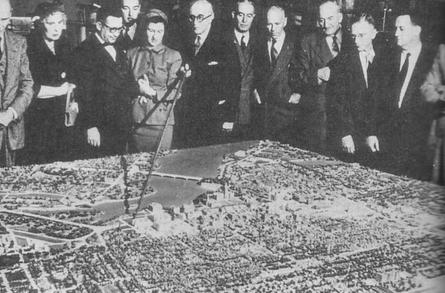 Jacques Gréber shows off the model of his plan for the National Capital to Members of Parliament, 30 April, 1949.The final 300-page report, along with the accompanying volume of maps, watercolours, and scale model of the city, was released on 18 November 1949 after more than four years of work. Mackenzie King, who had retired as prime minister the previous year, wrote the foreword to the report. In many ways, Gréber’s plan for the National Capital was King’s legacy to the country. The plan was also dedicated as a memorial to Canadian service people who died in World War II.
Before discussing its recommendations and their justification, the Report provided an in-depth survey of the National Capital Region, covering its physical characteristics, history, demographics, land use, housing, public buildings, transportation systems, with a special section on the railways, and recreational/touristic facilities. Sometimes the Report is more poetry than prose, referring, for example, to the “broad bosomed” Ottawa River and the “boisterous leaping Chaudière.” At one point it strays into conjecture, uncritically accepting the unsubstantiated claim that the 1916 fire that demolished the Centre Block on Parliament Hill was “set by a German hand.” Despite such quibbles, the Report is exhaustive, and makes a compelling case for its sweeping urban renewal plans for downtown Ottawa-Hull, and the preservation of rural greenspaces.
The key recommendation was the relocation of the railways and associated rail yards and warehouses out of the downtown core. Gréber argued that the tracks had been laid to serve the interest of their operators and the lumber barons rather than those of the broader community. Originally on the outskirts of the city, the railways had been constructed without regard for future urban expansion. In addition to beautifying the city, their removal would return the city to its citizens by eliminating rail barriers that divided neighbourhoods, improve safety, and speed traffic circulation. Replacing the railways would be a network of highways, urban arteries, and tree-line parkways. Gréber recommended the construction of two new bridges across the Ottawa River on the outskirts of the city that would link the Ontario and Quebec highway systems, one in the west over Nepean Bay at Lemieux Island, and another in the east over Upper Duck Island. Gréber also sought the elimination of Ottawa’s trolleys as their overhead wires and related infrastructure in the downtown core detracted from the beauty and monumental nature of the area.
Other important recommendations included urban renewal for blighted neighbourhoods close to Parliament Hill, such as LeBreton Flats, the elimination of the war-time “temporary” buildings that littered the city, the imposition of strict building regulations to preserve the view of Parliament Hill, and the decentralization of government operations. To address urban sprawl, Gréber recommended that the Government acquire land to build a greenbelt around the city. He also favoured the expansion of Gatineau Park and the preservation of neighbouring forests and rural areas for recreational and touristic purposes. In downtown Ottawa, he recommended the construction of a number of large monumental buildings, including an Auditorium and Convention Centre on Lyon Street between Sparks and Albert Streets, the establishment of a National Theatre on Elgin Street, a National Gallery on Cartier Square, and a National Library on Sussex Street, north of Boteler Street. Noting that, a “capital without a dignified City Hall is a paradox,” Gréber proposed the construction of a new Ottawa City Hall to replace the one destroyed by fire in 1931 but never rebuilt. His proposed building fronted on Nicholas Street with a new bridge across the Rideau Canal at that point. He also recommended relocating Carleton College (the forerunner of Carleton University) to the fields of the Experimental Farm along Fisher Avenue. Finally, in keeping with the idea that the redesigned National Capital Region would be a memorial to Canada’s war heroes, Gréber planned a giant memorial terrace at the southernmost point of the Gatineau Hills with “an imposing panoramic view” of Ottawa.
As one might expect with any such sweeping plan, there was opposition; many of Gréber’s recommendations were rejected or ignored. But the French urban planner got his way on two key recommendations—the relocation of the railways out of downtown Ottawa, and the establishment of a greenbelt. Through land swaps between the FDC and the railways companies, downtown Union Station, which was across the street from the Château Laurier Hotel, was replaced with a new passenger station built south of the city on Tremblay Road. The unsightly, 600 foot long, train shed at Union Station was demolished, and the tracks that ran alongside the Rideau Canal were removed, making way for Colonel By Drive. Similarly, the Ottawa West freight station and tracks at LeBreton Flats were expropriated. Ottawa’s rattling trams with their unsightly overhead wires were also retired in favour of more economical buses. Earning the gratitude of future residents, the Federal Government was also able to push through Gréber’s greenbelt proposal south of the Capital, despite opposition from suburban townships—Nepean politicians called the greenbelt the “weed belt.”
On other issues, Gréber was less successful. His idea of a huge war memorial in Gatineau was dropped owing to opposition from veterans who wished to commemorate World War II dead at the National War Memorial in downtown Ottawa. Most of the monumental buildings he planned for the downtown core were never built, or were located elsewhere, though his call for the demolition of the “temporary” war-time office buildings was heeded, albeit over a very long time, with the last one—the Justice Annex to the east of the Supreme Court building—only succumbing to the wrecking ball in 2012. His attempt to preserve the view of Parliament Hill from the south through height restrictions on commercial buildings also failed as high-rise office buildings, constructed to house federal civil servants, blocked the view. Similarly, his attempt to rejuvenate the LeBreton Flats took more than a generation to get underway owing in part to changing government priorities and inertia. Fifty years after the blighted neighbourhood was demolished, it remains a work in progress.
With hindsight, Gréber’s preference for the automobile over trains and trams, also had its downside, in part because he grossly under-estimated the expected future population of the National Capital Region. He had anticipated a population on the order of 500,000-600,000 by 2020, compared to 1.4 million today. Like the railways that preceded them, highways and major urban arteries came to divide neighbourhoods. A case in point is the Queensway which replaced the east-west CN rail line; Gréber had envisaged a tree-lined boulevard. Many mourn the loss of a downtown train station, and the passing of the city’s tram lines. The failure to build two new bridges across the Ottawa River at the city’s periphery linking the Ontario and Quebec highway systems has meant that interprovincial traffic continues to be routed across downtown bridges, aggravating traffic woes. Finally, the development of the greenbelt did little to stop urban sprawl as Gréber had hoped. Instead of the greenbelt promoting the development of self-contained satellite communities as he had envisaged, the automobile permitted them to become bedroom communities for Ottawa, and in the process further contributed to traffic congestion.
In sum, the Gréber Plan was marred by faulty assumptions and inadequate follow-through. But, despite all, Ottawa was transformed from a grimy, industrial city to a capital Canadians can be proud of. For that, we must give a big hand to the vision of Jacques Gréber.
Sources:
Butler, Don, 2012. “Putting things back on track for Ottawa’s train station,” 27 May, The Ottawa Citizen, http://www.ottawacitizen.com/news/Putting+things+back+track+Ottawa+train+station/6690940/story.html.
City of Ottawa, 2010-15. Relocating the Rail Lines, http://ottawa.ca/en/residents/arts-culture-and-community/museums-and-heritage/witness-change-visions-andrews-newton-6.
Gordon, David. 2000. Weaving a Modern Plan for Canada’s Capital: Jacques Gréber and the 1950 Plan for the National Capital Region, https://qshare.queensu.ca/Users01/gordond/planningcanadascapital/greber1950/Greber_review.htm.
Théoret, Huger, 2013. “Le plan Gréber dévoilé aux Communes,” Le Droit, 8 mars.
NCC Watch, 2003(?). NCC Blunders: Ottawa’s Union Station, http://nccwatch.org/blunders/unionstation.htm.
The Ottawa Citizen, 1945. “Canadian Architectural Institute Protest Hiring of Jacques Greber,” 2 October.
———————-, 1945. “Jacques Greber Arrives to Plan National Capital,” 2 October.
National Capital Planning Committee, 1950. “Plan for the National Capital,” (The Gréber Report), https://qshare.queensu.ca/Users01/gordond/planningcanadascapital/greber1950/index.htm.
Macleod, Ian, 2014. “The lost train of nowhere,” The Ottawa Citizen, 18 December, http://ottawacitizen.com/news/local-news/from-the-archives-the-lost-train-of-nowhere.
Images:
Intersection of Wellington Street and Lyon Street, looking south, 1936, the Gréber Report, Illustration #153.
Jacques Gréber shows off the model of his plan for the National Capital to Members of Parliament, 30 April, 1949,National Capital Commission, 172-5, http://www.lapresse.ca/le-droit/dossiers/100-evenements-historiques/201303/08/01-4629049-16-le-plan-greber-devoile-aux-communes.php.
Retired from the Bank of Canada, James is the author or co-author of three books dealing with some aspect of Canadian history. These comprise: A History of the Canadian Dollar, 2005, Bank of Canada, The Bank of Canada of James Elliott Coyne: Challenges, Confrontation and Change,” 2009, Queen’s University Press, and with Jill Moxley, Faking It! A History of Counterfeiting in Canada, 2013, General Store Publishing House, Renfrew, Ontario. James is a Director of The Historical Society of Ottawa.
The Great Farini Crosses the Chaudière Falls
9 September 1864
Back in the mid-nineteenth century, the world was wowed by Jean François Gravelet, better known as the Great Blondin. In June 1859, in front of a crowd of 25,000 fascinated and horrified onlookers, Blondin crossed the Niagara Gorge from the United States to Canada on a tightrope. On his return trip, he brought a daguerreotype camera with him to take a photo of the spectators.
One of Blondin’s greatest fans was a young man from Port Hope, Ontario named William Leonard Hunt. Hunt was born in June 1838 in Lockport, New York but grew up close to Port Hope where his parents settled after living for a time in the United States. As a child, he was a daredevil and was fascinated with all things related to the circus—much to his parents’ chagrin who view such activities as dishonourable. Hunt gave his first professional performance as a funambulist (tightrope walker) at age twenty-one by crossing the Ganaraska River in Port Hope on a rope stretched eighty feet high between two buildings, just months after Blondin’s conquest of Niagara Falls. Hunt chose the stage name Signor Guillermo (Italian for William) Farini, or the “Great Farini.”
The Great Farini challenged Blondin to a battle of who would be considered the greatest tightrope walker in the world. Signor Farini matched his idol’s feat by crossing the Niagara Gorge in June 1860. He topped off his performance by hanging from the rope mid-river by one hand, then suspending himself by just his feet. On a subsequent trip, after securing his pole, he climbed down a rope to the tourist boat Maid of the Mist circling below in the Niagara River, drank a glass of wine, and then climbed back up to finish his journey across the Gorge.
The rivalry of the two men took off. Blondin walked across the Falls with his feet in bushel baskets, pushed his manager in a wheel barrow, and even cooked omelettes on a portable stove high above the whirlpools, which he lowered to sightseers on the Maid of the Mist below. Farini responded by carrying his much larger manager across the Falls. Mid-river, Farini somehow unloaded his manager onto the rope, crawled on the underside of the rope beneath his friend to emerge on the other side, and then reloaded him onto his back before finishing the crossing. (Where do you find friends like this?!) Subsequently, Farini washed hankies mid-river using an Empire Washing Machine that he had brought with him across the high wire.
Needless to say, Farini was a sensation. It helped that he was darkly handsome, muscular, with brilliant blue eyes and slicked back black hair. He also worn a goatee with a waxed moustache that extended horizontally several inches on either side of his nose in a style popularized by France’s Napoleon III. He was also extremely articulate and spoke several languages.
After a brief stint in the Union Army in the United States during the American Civil War where he rose to the rank of Captain in the Engineers, he returned to the circus. While performing with his first wife, Mary, in a high wire act above the Plaza de Toros in Havana, Cuba in December 1862, tragedy struck. On their fifth crossing with his wife on his back, Mary unexpectedly waved to cheering spectators. Losing her balance, she fell. Somehow, Farini managed to grab her costume as she tumbled past him, but it was not enough. The fabric ripped and she fell sixty feet in front of a horrified crowd of 15,000 people. She died a few days later.
This catastrophe did not stop his high-wire career. In 1864, he came to Ottawa, which was then in the news owing to negotiations underway in Charlottetown, Prince Edward Island among the British colonies in North America on Confederation. If those negotiations were successful, Ottawa would become the capital of a large new nation.
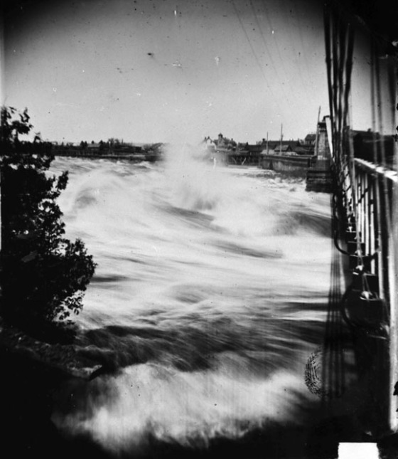 The Chaudière Falls with the Union Suspension Bridge on the right.
Circa 1869, Topley Studio, Library and Archives Canada, PA-102695According to Shane Peacock, the author of the definitive biography of the famed tightrope walker, Farini arrived in Ottawa in mid-August, 1864, booking into the Russell House, Ottawa’s premier hotel at the time. His first job was to suss out a likely spot for a high-wire act. He initially thought of crossing the Rideau Canal on a rope strung from Barrick Hill, where the new Parliament buildings were still under construction, to a tower located in what is now Major’s Hill Park. Deciding that such a route was insufficiently death-defying, he chose instead to cross the Ottawa River above the Chaudière Falls. Back in those days, the Chaudière Falls were not the tamed affair they are now but a raging torrent. The Ring Dam that regulates the flow of water over the Falls for the purpose of generating hydro-electricity would not be built for another fifty years. The only way over them at that time, and the only way between Ottawa and Hull, was the Union Suspension Bridge built in 1843. This bridge was later replaced by today’s Chaudière Bridge.
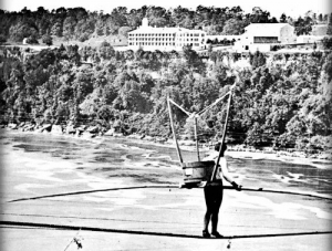
In the days prior to his much advertised crossing, set for Friday, 9 September 1864, work began on suspending a two-inch diameter rope from two heavily-braced wooden towers, one on Table Rock on the Quebec side of the Ottawa River, a short distance upstream from the Union Suspension Bridge, and the other on the Booth lumber mill on Chaudière Island on the Ontario side. The rope was advertised as being 1,000 feet long and 100 feet high. Messrs Perley and Booth along with other mill owners constructed a private viewing stand complete with comfortable seats for the pleasure of Ottawa’s elite. Cost was 25 cents per seat with access to the site provided through the Perley & Company Mill and Brewery or through Mr Booth’s new mill. The general public could watch for free from other vantage points.
The Chaudière Falls stunt wasn’t the only performance planned for Ottawa by the Great Farini. On the Wednesday before his aerial show, Farini gave a charity performance in aid of the new General Hospital, “putting his acrobatic skills at the disposal of the Sisters of Charity.” On the day of his crossing, he also performed at the Theatre Royal where he again demonstrated his gymnastic virtuosity as well as his circus tricks, including the flying trapeze and placing a 400-pound stone on his chest and having somebody smash it with an 18-pound sledge hammer. He also held a man up at arm’s length, a feat that had previously earned him a silver medal from New York gymnasts.
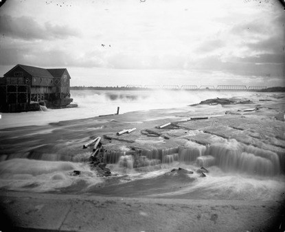 The J.R. Booth Lumber Mill, Chaudière Island, where Farini started his crossing of the Ottawa River. The Prince of Wales Bridge, built in 1880, is in the background.
Late 19th century, William James Topley, Library and Archives Canada, PA-012377.As you can imagine, there was a lot of press hype for Senior Farini’s death-defying tight rope act across the Ottawa River. Half-price trains and excursion boats ran on the Friday of his performance. A special train brought up U.S. spectators from Ogdensburg, New York with extra ferries laid on to take them across the St Lawrence River to meet a special train leaving Prescott for Ottawa at 8am and to return late that night. The Ogdensburg Advance wrote that Farini was “said to excel the great Blondin, not only in hazardous undertakings, by in ease and grace of their accomplishment.” The newspaper also put a plug in for the Russell Hotel saying that its proprietor, “our friend Gouin,” was “always alive to the comfort and convenience of the public,” and dispensed services that “epicures most delight in.” It added that the Russell House ranked among the finest hotels in Canada, and urged excursionists going to Ottawa to “drop in at the Russell House and ‘smile.’”
Monsieur Gouin, of course, hoped they would do more than smile. He advertised first class rooms at only “$4 US currency per day” for visitors to Ottawa to watch Farini cross the Chaudière Falls. This was a real bargain. With the United States in the midst of its Civil War, US$4 was worth much less in Canadian dollar terms. (In mid-July 1864, the U.S. dollar, which was off the gold standard, touched an all-time low against its Canadian counterpart of US$2.78 to one Canadian dollar.) Of course, visitors could also find the best food and drink at the Russell House.
Friday, 9 September 1864 was a perfect day for Farini’s crossings of the Ottawa River. Two performances were organized, with the first beginning at 3pm and the second at 9 pm after his show at the Theatre Royal. Some 15,000 people turned out to watch. Given that the population of Ottawa was less than 15,000 in the 1861 census this is a remarkable number of people, even allowing for population growth and visitors. One of the best vantage points was on the Union Suspension Bridge. However, fearing an accident given the number of people crowding on to it, the bridge keeper closed the gates leading from the Ottawa side.
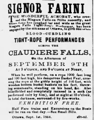 Advertisement for the Great Farini.
The Ottawa Citizen, 6 September 1864Spectators were not disappointed. Farini put on a masterful show. Dressed like a circus acrobat, Farini crossed the Chaudière Falls three times during the one hour-long afternoon show. He crossed with and without a pole, did acrobatics, and hanged upside down from his feet over the raging water. On his second trip, he wore wooden bushel baskets typically used for measuring oats on his feet. For a finale, he crossed in a sack.
As Farini was performing, he was almost upstaged by a young boy, no more than eleven years of age, who managed to climb around a fence that jutted out over the fast-flowing river and cordoned off the eastern side of the reserved area at the Perely and Booth mills. When spectators finally saw what the lad was doing, many rushed over to pull him to safety. But before they could do so, he swung himself around the end of the fence, dangling temporarily over the rapids, before pulling himself to safety and disappearing into the milling crowd.
After talking to the press and well-wishers at the Russell Hotel following his afternoon performance, and giving his evening show at the Theatre Royal—tickets were 25 cents each—Farini repeated his Chaudière Falls crossings at 9pm. As it was well past sunset, he performed to the light of fire-works. According to Shane Peacock, he cut short the evening performance at the request of Ottawa authorities who feared an accident owing to the press of the crowds.
Farini left Ottawa shortly afterwards to perform in Montreal; he never returned. By 1866, he had begun regular performances in England with a young boy, Samuel Wasgatt, whom he later adopted. Called El Niño (the child), young Sam and Farini performed as The Flying Farinis. When El Niño got a bit older, he began performing aerial acrobatics as a woman with long blond hair under the stage name “The Beautiful Lulu, the Circassian Catapultist.” He wasn’t “outed” as a man until 1878.
By this time, the elder Farini, had married an English girl, Alice Carpenter, and had retired his leotards in favour of managing celebrity performers and developing new circus tricks, including the first human cannonball act. For a time, he partnered with the famed P.T. Barnum assembling human oddities, included Krao, a hairy Laotian girl who Farini advertised as The Missing Link. He later adopted the girl. During the mid-1880s, the now divorced Hunt, accompanied by his son Sam, the former Lulu, trekked through southern Africa where they claimed to have discovered the Lost Kingdom of the Kalahari. Photographs taken by Sam and a paper written by Farini, which he presented at the Royal Geographic Society in London, caused a sensation…and sparked a decades’ long quest by explorers. Reportedly, some twenty-five expeditions were launched to find the fabled kingdom which stubbornly remained lost.
In 1886, he married his third wife, German-born Anna Mueller. A man of many parts, he took up horticulture, writing books on New Zealand ferns, and begonias. He later began to paint. In the early 1900s, he and his wife moved back to Canada from England. In Toronto, he apparently dabbled in the stock market, and was involved in a gold mining company. He was also an inventor of some renown, including, among other things, folding theatre seats. Moving to Germany in 1909, Farini spent World War I in that country where he wrote a multi-volume account of the war from a German perspective. In 1920, Farini and his wife returned to North America. After moving around a bit, the couple settled down in Farini’s home town of Port Hope, where he died of the flu in 1929 at the ripe old age of 90.
Sources:
Itchy Feet, Itchy Mind, 2014. The Great Farini, Lulu Farini, And The Lost City Of The Kalahari, 2014, https://itchyfeetandmore.com/2014/12/16/the-farinis-and-the-kalahari-lost-city/.
Ottawa Citizen, 1864. “Signor Farini performing at Theatre Royal,” 9 September.
——————, 1864. “Signor Farini,” 6 September.
——————, 1864, “No title,” 7 October.
Ottawa Journal, 1931. “Signor Farini was a Great Rope Man,” 31 October.
——————, 1950. “340 Years of History Flowed by Chaudiere,” 17 June.
Peacock, Shane, 1995. The Great Farini: The Hire-Wire Life OF William Hunt,” Viking: Toronto.
Story written by James Powell, the author of the blog Today in Ottawa's History.
Retired from the Bank of Canada, James is the author or co-author of three books dealing with some aspect of Canadian history. These comprise: A History of the Canadian Dollar, 2005, Bank of Canada, The Bank of Canada of James Elliott Coyne: Challenges, Confrontation and Change,” 2009, Queen’s University Press, and with Jill Moxley, Faking It! A History of Counterfeiting in Canada, 2013, General Store Publishing House, Renfrew, Ontario. James is a Director of The Historical Society of Ottawa.
The Last Timber Raft
8 July 1908
These days, Ottawa has become a synonym for “the government” much to the chagrin of the city’s residents. Newspapers constantly complain about things that “Ottawa” has done. This is understandable since government is the principal industry of the city. One in five jobs in the Ottawa-Gatineau area is with the federal government, a fraction that rises to one in four if you include other levels of administration. This wasn’t always the case. At the beginning of the twentieth century, trees, not politics, were central to the economic prosperity of Ottawa, and of Hull, its sister community on the other side of the Ottawa River. Saw mills and pulp and paper factories which crowded the shores of the Ottawa River, especially in the Chaudière district, employed thousands. Communities the length of the Ottawa Valley also depended on the forestry business, felling and shipping logs to Ottawa and Hull for processing.
The lumber business in the Ottawa Valley began with Philemon Wright, the man from Woburn, Massachusetts who led the first Europeans to the region, settling on the north shore of the Ottawa River in 1800 in what would later be called Hull, Quebec. The settlers, initially intent on farming, discovered a pristine forest that stretched for as far as the eye could see. By one estimate, the untouched Ottawa Valley, in which the land’s Indigenous people had liven for countless generations, comprised 28 million acres of dense woodland. The settlers quickly turned to exploiting this vast and seemingly inexhaustible resource, containing more than 500 billion board feet of valuable timber (A board foot is a measure of lumber volume, being one foot by one foot by one inch.)
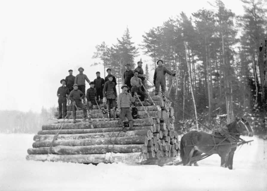 Hauling Logs in the Ottawa Valley, Topley Studio, Library and Archives Canada
This ancient woodland was very different from what little remains of the Valley’s forest today. It was estimated that roughly one half of the original forest was made up of white and red pine. A further 45 per cent consisted of other soft woods, such as spruce, balsam and hemlock. The remaining 5 per cent of the woodland was maple, oak, basswood and other species of hard woods. The old-growth trees were also enormous by today’s standards, with stands of white pine rising more than 100 feet.
In June 1806, Philemon Wright navigated the first log raft, christened the Columbo, from the confluence of the Gatineau and Ottawa Rivers down the Ottawa to the St. Lawrence and on to market in Quebec City for sale to the Royal Navy. At that time, Britain was fighting Napoleon’s France. With Britain’s usual Baltic supply of Norwegian pine cut off due to a French blockade, it looked to Canada’s white (sometimes referred to as yellow) pine as a replacement. The tall, straight, first growth trees made ideal masts and spars for its naval vessels.
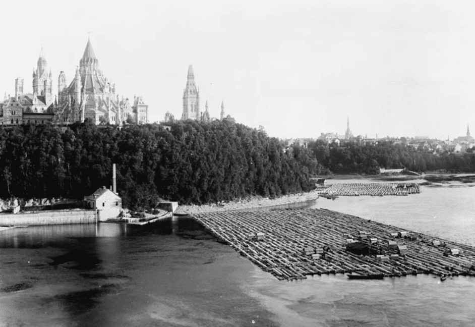 The assembling of a timber raft on the Ottawa River below Parliament Hill. Topley, Library and Archives Canada, PA-00843.
To get the timber to Quebec City, Irish and French lumbermen squared the pine logs. The “sticks,” as they were called, were pulled by teams of horses over greased slides to be launched into the water. There, they were bound together to form cribs using withes, strong, flexible branches of birch and alder. Four cribs made a band. The bands were joined together to assemble a raft. On the raft were cabins to house a crew of thirty or more men. The captain had his own quarters, sufficiently commodious to accommodate the occasional passenger. There was also a cook-house to prepare food and to brew tea.
Travelling down the Ottawa and St. Lawrence Rivers on a log raft was difficult and perilous, especially during the early days before timber slides were built so that rafts could circumvent fast water. The first such slide was built in 1829 by Ruggles Wright, the son of Philemon Wright, on the north side of the Ottawa River to pass logs around the Chaudière Falls, known in English as the Giant Cauldron. Other rapids that had to be bypassed on the way to Quebec City were found at Long Sault near Cornwall, and Lachine, both on the St. Lawrence.
Even with the construction of timber slides to ease their passage, the big rafts had to be broken down into component cribs before entering a slide, and reassembled afterwards. The journey from Ottawa to Quebec City could take a month or more. However, it wasn’t all hard work, at least for the owners. It is reported that lumber barons hosted large parties of MPs and senators to lunches of pork and beans before departing Ottawa. Also, along the way, raft captains entertained lavishly at various stops during the voyage.
Once in Quebec City, the big timber rafts were disassembled in nearby coves, and sold to waiting British merchants for shipment to Liverpool and other British ports.
In 1836, the Ottawa Valley Lumber Association was formed in Bytown, with meetings held in Doran’s Hotel, the town’s chief waterhole of the age. Early lumbermen included James Skead, David Maclaren, J.S. Currier, and the Buchanan brothers, Andrew and Charles. While the square timber trade was generally very profitable, it was also precarious. John Egan, for whom Eganville, Ontario is named, was a power in the timber trade during the mid-nineteenth century, but went bankrupt in 1854 when prices unexpectedly fell.
The era of the square timber raft peaked during the 1840s, and steadily waned thereafter. Mid-century, Britain adopted a free-trade economic policy thereby eliminating a trade preference enjoyed by Canadian timber producers since the Napoleonic Wars. The Royal Navy’s demand for Canadian pine also declined as the age of sail gave way to that of steam.
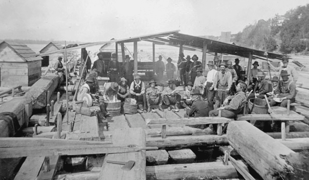 Cook house on a timber raft, Andrew Auborn Merrilees Fonds, Library and Archives Canada, ID No. 3277723.
But Ottawa’s lumber industry adapted. Demand for Canadian sawn timber rose in the rapidly growing eastern cities of New York and Boston. U.S. entrepreneurs, such as Captain Levi Young, Franklin Bronson, Ezra Eddy, and J.R. Booth, established sawmills on the shores of the Ottawa River, harnessing its fast-flowing water to power their large timber saws. In 1874, 424 million board feet of timber were cut in Ottawa-area sawmills, along with a further 25 million board feet of square timber. The biggest lumber producer at that time was the E.B. Eddy Company whose output amounted to 55 million board feet. Close behind was Gilmour and Company which produced another 50 million board feet. J.R. Booth’s company cut a further 22 million board feet of timber.
By 1902, 613 million board feet of timber were being produced by nineteen sawmills in the Ottawa Valley. J.R. Booth had vaulted into the number one spot, producing an amazing 125 million board feet of timber. His sawmill was reportedly the largest in the world, able to produce more than 1 million board feet of sawn timber in one eleven-hour day.
As the supply of white and red pine in the Ottawa Valley rapidly diminished, Ottawa’s lumber business turned increasingly to pulp and paper production, making use of the spruce and balsam firs which hitherto had been considered of little value. In 1878, E.B. Eddy constructed the first mechanical pulp mill for the manufacture of fibre products. By 1908, E.B. Eddy was producing 160 tons of pulp every day. In 1926, Eddy built a massive sulphite chemical pulp mill in Hull immediately across the Ottawa River from the Parliament buildings.
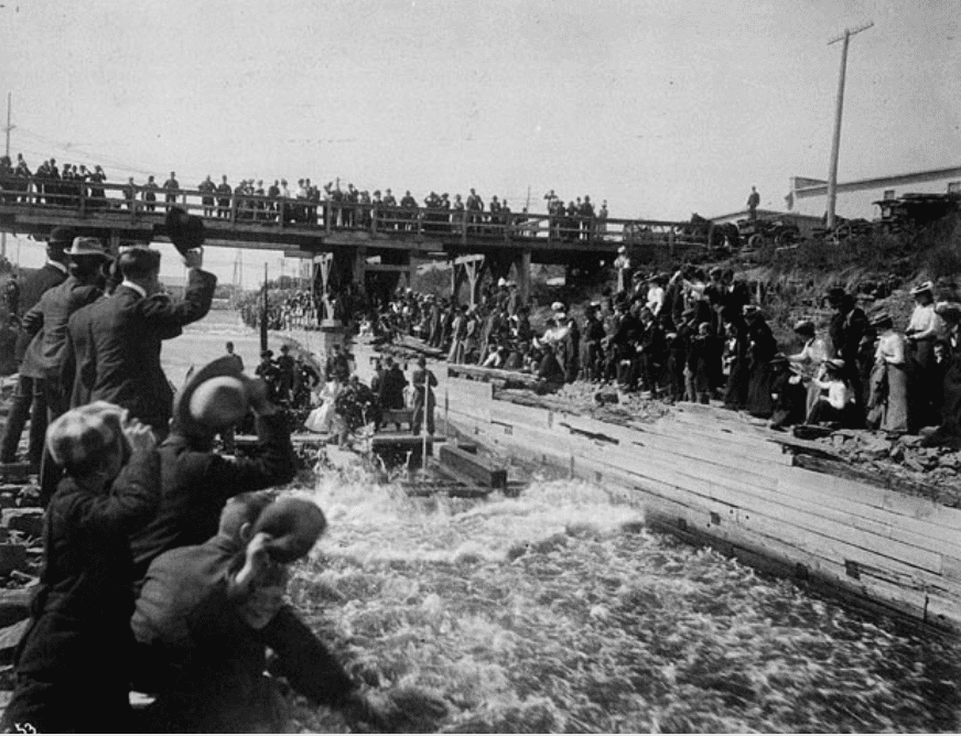 The Duke of Cornwall and York and the Royal Party taking a ride on a crib through the Chaudière log slide, 1901, Charles Berkley fonds, Library and Archives Canada, ID No. 3294381.
Owing to waning demand for square timber, and a declining supply of big pine trees, fewer and fewer timber rafts made their way from Ottawa to Quebec City by the end of the nineteenth century. The few that did attracted much attention as the big timber rafts were broken up to make the trip through the government timber slide at the Chaudière Falls before being reassembled below the Parliament buildings for the next leg in their journey to the old capital. Timber rafting became a tourist and spectator sport. An exhilarating trip through the timber slide on a crib became a de rigueur experience for visiting dignitaries. In 1901, the Duke of Cornwall and York, later King George V, took the plunge, just as his father had in 1860.
The last square timber raft to leave for Quebec City from Ottawa began its journey in mid-June 1908 from the upper reaches of the Ottawa River. The Ottawa Citizen reported that the largest raft in years, totalling 135 cribs, owned by J.R. Booth, had descended the Black River in Quebec. The newspaper advised people who wished to see the sight of it shooting the Grand Calumet slide upstream on the Ottawa River to take the CPR train to Campbell’s Bay and the stage to Bryson, Quebec.
On or about 8 July 1908, this last timber raft was ready for its transit through the government slide at the Chaudière Falls. We know this date from newspaper accounts of an inquiry into a hit and run accident that occurred in Ottawa. The suspect, a hackman, F.J.X. Lascelles, had been hired on 8 July to work on Booth’s timber raft going to Quebec City. Another newspaper account two days later advised people to go watch the running of the cribs through the Chaudière timber slide then underway as it was “probably the last [timber raft] that will ever pass down the Ottawa to Quebec City.” Hundreds of spectators took the newspaper’s advice to watch the event. After passing through the slide, the cribs were reassembled below the Parliament buildings into the log raft for its voyage to Quebec City under the direction of pilot Ephrem Lalonde, a raftsman of more than forty years’ experience.
The Ottawa Citizen remarked that this was the end of the adventurous method of transporting timber which had been the most picturesque feature of the timber industry. Subsequent loads of timber were transported by rail.
After peaking during the beginning the twentieth century, the Ottawa Valley timber industry entered a long decline as its supply of wood dwindled. By the mid-1920s, it was estimated that less than four percent of the Ottawa Valley’s original, old-growth forest remained, consisting of not more than 10 billion feet of pine of saw-sized timber, with a further 5 billion feet of other soft woods and 4 billion feet of hard woods. Secondary growth of soft and hard woods was deemed suitable only for pulp and firewood.
Lumbermen looked back in dismay at the wasteful practices of the past. Squaring logs led to the wastage of more than one-third of the wood. Giant hemlocks were cut down solely for their bark used for tanning leather, the wood left to rot where the trees were felled. Land clearances for farms destroyed countless acres of valuable timber. The dead branches and brush from cut trees also provided the fuel for massive forest fires that destroyed valuable stands of timber.
Today, the lumber and paper mills of Ottawa-Hull are mostly gone. The J.R. Booth Company was bought out by E.B. Eddy in 1943, the first of many mergers and closures. Domtar acquired the E.B. Eddy mills in Ottawa and Gatineau in 1998, and permanently closed them in 2005 and 2007, respectively. The site of the big Eddy pulp mill on the north shore of the Ottawa River across from Parliament Hill is now the location of the Canadian Museum of History. All that is left is the former Eddy paper mill on Laurier Street in the Hull sector of Gatineau. The mill has been owned by Kruger, a Quebec-based forest product company, since 1997.
Although the lumber industry was the backbone of the Ottawa economy for close to two hundred years, providing jobs for thousands, the prosperity that it generated came at a high environmental cost. The industry irrevocably altered the landscape of the Ottawa Valley with the destruction of virtually all of its original woodland. Along with it went the traditional way of life of the Indigenous people of the Ottawa Valley, who never ceded ownership of its territory to European setters. The industry also had serious negative consequences for the Ottawa River. Dams built to control water levels to facilitate the transport of logs and to power the sawmills disturbed fish habitats. Sunken logs, and saw dust, routinely dumped into the river, along with chemicals from the pulp and paper mills, and untreated city effluents, polluted the water, killed fish, and brought disease.
Fortunately, with the closure of most of the mills and more effective treatment of city sewage and runoff, water quality in the Ottawa River is improving. However, the extent of the improvement is not known. According to the Ottawa Riverkeeper, water quality monitoring is piecemeal throughout the Ottawa River watershed, and there is no program in place to monitor the quality of water in the Ottawa River over time.
A lasting legacy of Ottawa’s lumbering past is the ring dam at the Chaudière Falls. Once used to make electricity to drive the sawmills, it now produces clean energy to help power downtown Ottawa. While the once dirty industrial area has been greened and opened to the public, the dam’s continued presence remains controversial.
Forestry continues in the Ottawa Valley, though on a much-reduced scale from its glory days. Its focus today is on sustainable forestry practices that respect not only the economic value of the forest but also its cultural and ecological significance.
Sources:
Canadian Museum of History, 2020. The Timber Trade, https://www.historymuseum.ca/cmc/exhibitions/hist/canp1/ca14eng.html.
Hirsch, R. Forbes, 1985. The Upper Canada Timber Trade: a sketch, Bytown Pamphlet No. 14, Historical Society of Ottawa.
Ottawa Citizen, 1908. “Big Raft Coming,” 15 June.
——————, 1908. “Comment,” 10 July.
——————, 1908. “Police Doing Clever Work,” 17 July.
——————, 1926. “For Over One Hundred Years District Has Been Greatest Lumber Producer In Canada,” 16 August.
——————, 1936. “Had Exciting Adventure On A Journey To Quebec On A Raft,” 15 February.
——————, 2006. “Kruger to change Scott names as Kimberly-Clark deal ends,” 11 October.
Ottawa Journal, 1976. “Great timber trade began on Hull side,” 27 September.
Ottawa Riverkeeper, 2020. Water Quality and Quantity, https://www.ottawariverkeeper.ca/ottawa-river-water-quality/.
OttawaRiver.org, 2005. A Background Study for Nomination of the Ottawa River Under the Canadian Heritage Rivers System – 2005, https://ottawariver.org/pdf/01-intro.pdf.
Outaouais’ Forest History, 2020. http://www.histoireforestiereoutaouais.ca/en/.
Whitton, Charlotte, 1967. “The Ottawa: My land of the white pine tree,” Ottawa Citizen, 27 June.
Story written by James Powell, the author of the blog Today in Ottawa's History.
Retired from the Bank of Canada, James is the author or co-author of three books dealing with some aspect of Canadian history. These comprise: A History of the Canadian Dollar, 2005, Bank of Canada, The Bank of Canada of James Elliott Coyne: Challenges, Confrontation and Change,” 2009, Queen’s University Press, and with Jill Moxley, Faking It! A History of Counterfeiting in Canada, 2013, General Store Publishing House, Renfrew, Ontario. James is a Director of The Historical Society of Ottawa.
Britannia-on-the-Bay
24 May 1900
During the late nineteenth century, electricity was the big new invention that was transforming peoples’ lives. Within a short span of years, electric lights replaced gas lamps in homes, in businesses and on city streets in the major cities of North America. Horse-drawn public transportation was also retired in favour of electric streetcars, also known as trolleys. But while the fast and comfortable trolleys were very popular on weekdays and on Saturday mornings transporting commuters from the suburbs to downtown offices, streetcar companies found their vehicles underused on Saturday afternoons and Sundays. What to do? The answer was to increase weekend ridership by giving people someplace to go and something to do on their time off. Spurred by the success of Coney Island in New York City, transit companies in many major North American cities built amusement parks, colloquially known as “electric parks.” Constructed at the end of a streetcar line, these parks attracted thousands of working class men, women and children seeking weekend fun and excitement. Of course, people had to buy a streetcar ticket to get there; the days of the automobile were still in the future.
Ottawa-Hull was no exception to these trends. Thomas Ahearn and Warren Soper introduced the electric streetcar to the nation’s capital in 1891. Four years later, their Ottawa Electric Railway Company (OERC) opened the West End Park on Holland Avenue in Hintonburg, which was then on the outskirts of the city. Later known as Victoria Park, following the Diamond Jubilee of Queen Victoria in 1897, the park was the home to many rides and musical entertainments. The West End Park was the location of the showing of the first motion pictures in Ottawa in 1896. Across the Ottawa River two miles west of Aylmer, the Hull-Aylmer Electric Railway Company opened “Queen’s Park,” in May 1897, again named in honour of Queen Victoria, at the western terminus of its line. Among the attractions at this park, located on Lac Deschênes (a widening in the Ottawa River rather than an actual lake), were a merry-go-round, a water chute and a “mystic maze.”
To compete with the Queen’s Park development in Quebec, the OERC acquired eighteen acres of land in the little summer cottage community of Britannia Village to the west of Ottawa. There, it established in 1900 an amusement park, with swimming and boating facilities on the Ontario side of Lac Deschênes, with a purpose-built tramline linking the new park to downtown Ottawa. Appropriately, it was called the Britannia line. Thomas Ahearn gave journalists a sneak preview of the new line in mid-January 1900. Although the rails had been laid all the way to Britannia Village, at that date the electric lines only went as far as Richmond Road. But the tramline was completed in time for its official opening at 6am on the Queen’s Birthday holiday on 24 May 1900. From the post office at the corner of Sparks and Elgin Streets to Britannia-on-the-Bay tram stop took just twenty-eight minutes, much of which was through the city. The trip from Holland Avenue, the previous end of the line, to Britannia-on-the Bay, with stops at Westboro, Barry’s Wharf and Baker’s Bush, took only eight minutes. The cost for the trip from downtown was initially set at 10 cents—the usual 5 cent fare plus another five cents to travel on the newly completed Britannia line. The five-cent supplement was later dropped.
In and of itself, the trip to Britannia-on-the-Bay was an exciting adventure for Ottawa citizens at the dawn of the twentieth century. Carried in specially-made carriages, trolley goers were taken along rails that ran close to the south side of Richmond Road except for the last mile or so where they crossed Richmond Road to head into Britannia. After leaving the city, which essentially ended at Preston Street, people journeyed through fields of grain and cow pastures, past fine homes and shoreline cottages before reaching their destination. A journalist on the initial January test run said there was a number of long grades with several sharp turns that give the route “a rolling appearance” which will “add zest,” since “pleasure-seeking humanity likes a spice of danger with its bit of fun.” He added that between Hintonburg and Britannia, there were a number of lovely spots.
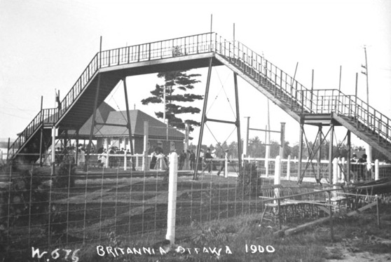 The footbridge over the CPR tracks at Britannia Park, 1900
Henry Joseph Woodside, Library & Archives Canada, PA-016975On reaching Britannia-on-the-Bay, riders crossed to the park, its beach and a long pier via a high footbridge, built at a cost of $1,500 by the OERC, which went over the Canadian Pacific Railway (CPR) tracks that ran north of the tramline. The footbridge allowed visitors to the park to avoid any danger of being hit by passing trains. On the other side were picnic gardens, concession stands as well as bathing and boating facilities on a thirty-foot wide pier that extended 1,050 feet into Lac Deschênes. The pier was built of wood with a stone base, using material excavated by the Metropolitan Power Company in an earlier failed attempt to build a canal and hydroelectric generating station at Britannia. Lit by electric lights at night, the pier was furnished with seating that ran along its length, perfect for visitors to sit and enjoy the sights, listen to band concerts, and to watch the promenading crowds. At the end of the pier was a perpendicular, two hundred foot long breakwater that protected moorings for boats. At the land end, two octagonal pavilions were erected at a cost of $2,500, housing a restaurant, changing rooms and bathrooms, a ladies’ parlour and sitting rooms.
The weather on opening day was bright and fine, attracting thousands of Ottawa picnickers to try out the OERC’s new park and pier at Britannia. Although the pavilions were not quite completed, they “were temporarily fitted up for use” for the estimated crowd of 12,000-15,000 visitors. The band of the 43rd Battalion gave a concert in the afternoon and evening to the multitudes. When darkness fell, the park was brilliantly illuminated by electric lights. Ten large arc lights lit up the pier.
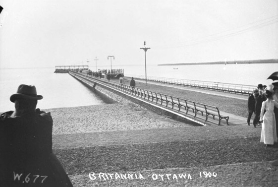 Britannia Pier, 1900
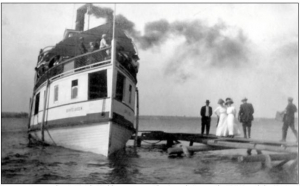
Henry Joseph Woodside, Library and Archives Canada, PA-016976The new Britannia Park was a big success, and over the next several years was considerably improved and expanded. With the new waterside park eclipsing the old Victoria Park on Holland Avenue, the OERC cannibalized the latter’s attractions, moving its merry-go-round and auditorium to Britannia. In 1904, the OERC increased the size of the park by buying the 35-acre Mosgrove property close to Carling Avenue. It also extended the pier by four hundred feet, at the end of which a three-story boat house was erected that became the Britannia Boating Club’s clubhouse. In addition to rooms for members and a lower storage area for boats and canoes, which were available for rent by visitors, the clubhouse had a large ballroom and grandstand for spectators. At night, a searchlight on top of the building played over the darkened waters of Lac Deschênes. Other attractions at Britannia Park included excursions on the double-decker, side-wheeler, steamer G.B. Greene, the “Queen” of the Ottawa River which took tourists upstream to Chats Falls two or three times a week. Through the summer, holidaymakers were entertained by the festivities and music of “Venetian Nights.”
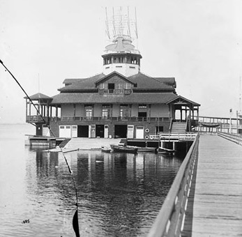 Britannia Boating Club, c. 1907
William James Topley, Library and Archives Canada, PA-009028Britannia Park enjoyed its peak of popularity before World War I. Then things started to sour. In 1916, the G.B. Greene burnt. Though it was rebuilt, with Canada at war sightseeing wasn’t as popular as in the past. The steamer ended up towing logs and was dismantled in 1946. In August 1918, the Clubhouse at the end of the pier was consumed by flames. Some two hundred canoes and boats, along with the personal effects of members as well as trophies, furnishings and other valuables were lost. Although the cause of the $50,000 fire was never accurately determined, it was believed that a lighted cigarette carelessly thrown into the window of a bathroom was to blame.
Through the 1920s, amusement parks everywhere began to lose their allure. With more and more families owning their own automobile, people had the luxury of exploring other entertainment options. No longer were they limited to where the trolley could take them. Queen’s Park outside of Aylmer closed. Britannia limped on. The Park’s Lakeside Gardens Pavilion still managed to pull in the crowds for dances through the 1930s. Sunday band concerts also remained popular. In the early 1930s, the OERC began promoting the Park as a great place for parents to send their children. For youngsters under 51 inches tall, (i.e. roughly 8 years old or less) the trolley company advertised that they could travel to Britannia for only 6 4/7 cents, total fare, if they purchased a book of seven tickets for 25 cents plus an additional 3 cent fare for the Britannia line. Under its policy of “Safety First,” the trolley company said that special attention and care would be given to children by its car men. “It is therefore possible to send children to Britannia-on-the-Bay with the assurance that they will be safe while going, while at the beach and while returning.” Clearly this was a different time with a different level of care expected of parents. Few today would consider sending young children to swim at a public beach on city transit without formal supervision.
By the late 1940s, Britannia Park and Britannia beach were becoming shabby from years of use and limited maintenance. Transit consultants advised the financially weak OERC to close the park. In 1948, the Ottawa Transport Commission, which was owned by the City of Ottawa, took over the transit company, including its Britannia property. Concerned that the park was continuing to deteriorate, the City decided in 1951 to operate it directly. Some improvements were made, including the building of a children’s miniature railway at the park. However, more grandiose plans that include a zoo, stock-car racing and two artificial pools never left the drawing board. Park infrastructure continued to rot. Meanwhile, the beach was becoming fouled by weeds and pollution. By 1954, what had been one of Canada’s top tourist attractions was now considered “Canada’s worst.” That year, the footbridge over the CPR tracks was demolished. (The trains themselves continued to go through the Park until they were re-located out of downtown Ottawa in 1966.) In 1955, the aging Lakeside Gardens burnt to the ground.
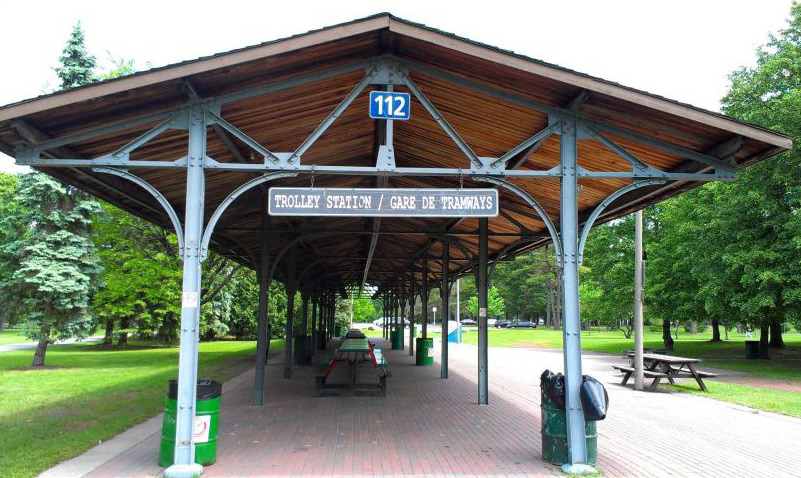 Defunct Trolley Station Britannia Park, 2015
Photo by James Powell
New investments were finally made into the park in 1958. The rotting wooden pier, now deemed unsafe, was demolished. The stone base of the original 1,050 foot pier built in 1900 was widened and the beach expanded. Lakeside Gardens was also rebuilt for dances. With these changes, the Park experienced a brief renaissance. However, it was not to last, doomed by changing tastes, and for Lakeside Gardens, the lack of a liquor licence. The beach was also increasingly shunned owing to a persistent weed problem. City efforts to control the weeds using bulldozers, chemicals and tons of rock salt proved fruitless. (This was a time before much consideration was given to the environment.) In any event, pollution closed the beach for extended periods. During the 1960s and 1970s, Britannia Park was threatened by a planned extension of the Ottawa River Parkway (today’s Sir John A. Macdonald Parkway) through the Park using the old CPR right-of-way, now turned into a bike path, as well as the construction of the Deschênes Bridge that would have link Aylmer to Ottawa. Both ideas were finally scuppered by opposition from area residents and changing government priorities.
Today, Britannia Village, annexed by Ottawa in 1950, is no longer a remote summer cottage community. Businesses and housing have long filled the open space between the old City of Ottawa and Britannia and beyond. The streetcars that once linked it to downtown are gone; the last trolley to Britannia-on-the-Bay rode into history in 1959. But the magnificent park and beach endure. Owing to the marked improvement to the water quality of the Ottawa River due to the closure of the pulp and paper mills that had polluted it with their effluent, and the treatment of sewage by riverine communities, boaters and swimmers have returned. While Britannia Park and its beach may no longer attract the hordes of day trippers they did every weekend one hundred years ago, they remain a popular summer destination for people trying to escape the heat of the City. The Ron Kolbus-Lakeside Centre, formerly the Lakeside Gardens, also continues to host big band dances as well as education courses ranging from the arts and crafts and dog obedience, to yoga and fitness.
Sources:
Evening Journal, (The), 1897. “Handled The Motor,” 27 May.
—————————-, 1900. “The New Electric Line To Britannia,” 15 January.
—————————-, 1900. “Searchlight on Lake Deschenes,” 2 April.
—————————, 1900. “Ottawans Loyally Observed the 24th,” 25 May.
—————————, 1906. “A Good Show At Britannia,” 22 May.
—————————, 1918. “Britannia Club House Is Destroyed By Fire Loss Nearly $50,000,” 30 August.
—————————, 1931. “The Children’s Beach At Britannia-on-the-Bay.” 13 July.
—————————, 1948, “Battle Of Seaweed Goes On At Britannia,” 1 May.
—————————, 1951. “Britannia Park Is Saved,” 21 June.
—————————, 1954. “Recommend Closing Britannia Park Amusement Centre,” 27 May.
—————————, 1954. “State of Britannia Park,” 28 May.
—————————, 1954, “At Last New Deal Coming For Battered Britannia Park,” 23 July.
Ottawa, (City of), 2016. Ron Kolbus-Lakeside Centre.
Taylor, Eva & Kennedy, James, 1983. Ottawa’s Britannia, Britannia Historical Association, Ottawa.
Story written by James Powell, the author of the blog Today in Ottawa's History.
Retired from the Bank of Canada, James is the author or co-author of three books dealing with some aspect of Canadian history. These comprise: A History of the Canadian Dollar, 2005, Bank of Canada, The Bank of Canada of James Elliott Coyne: Challenges, Confrontation and Change,” 2009, Queen’s University Press, and with Jill Moxley, Faking It! A History of Counterfeiting in Canada, 2013, General Store Publishing House, Renfrew, Ontario. James is a Director of The Historical Society of Ottawa.


