Working to preserve Ottawa's past
for future generations.
The Grand Chaudière Dam

16 October 1868
We have in our very midst unrivalled water powers, and it would argue the utmost lack of energy, the blindest fatuity, were they to remain undeveloped. “Impressions of Ottawa,” Ottawa Citizen, 6 November 1860.
The mighty Ottawa River, also known as the Kichissippi in Algonquin and the Outaouais in French, stretches more than 1,100 kilometres. Its source is Lac Capitmichigama in central Quebec from which it runs west to Lake Timiskaming before heading south to form the boundary between Ontario and Quebec, passing through the National Capital Region on its way to meet the St. Lawrence at the Lac des Deux Montagnes in Montreal. Its watershed covers an area of more than 146,000 square kilometres.
For countless generations, the Ottawa was a key transportation and trading route for the Indigenous peoples of this land. Later, it became the route for European explorers and settlers into Canada’s interior. Led by native guides, Samuel de Champlain explored the Ottawa River in 1613. It subsequently became an important thoroughfare for French voyageurs and coureurs des bois trading manufactured goods with the First Nations for beaver and other pelts which were in high demand in Europe. Later still, loggers and lumbermen of the nineteenth and twentieth centuries, who were exploiting the ancient forests of the Ottawa Valley, relied on the river to transport logs and square timber (logs that had been stripped of their bark and roughly squared) to markets.
With a vertical descent of 365 metres, the Ottawa River is turbulent and fast-flowing even today despite more than 50 dams and hydro facilities constructed along its main branch and tributaries. According to the Ottawa Riverkeeper, the Ottawa is one of the most regulated rivers in Canada. Nonetheless, it remains a magnet for white-water canoers and rafters.
For nineteenth century lumbermen trying to bring rafts of logs down the Ottawa, its rapids and falls were a nightmare, posing dangers to life and limb. However, the entrepreneurs of Ottawa and Hull saw the potential for profit from those same rapids and falls if they could be harnessed to produce the motive power necessary to drive the big saws that processed the raw lumber. By damming the Ottawa, mill owners could channel the flow of water through their mills. A tamed river also meant a safer river for the log drivers.
One of the major obstacles on the Ottawa River was the Chaudière Falls, known as the Giant Kettle in English. In 1829, Ruggles Wright, the son of Philemon Wright who founded Hull, built a timber slide on the Quebec side of the river to permit logs and rafts of timber to bypass the falls. Three years later, another slide was constructed by George Buchanan on the Ontario side of the river. To build the slide, a dam was constructed that ran roughly parallel to the shore to divert water into a channel. (The dam can be seen in an 1832 plan of the first Union Bridge across the Ottawa River by Joseph Bouchette.)
In 1854, at the behest of the mill-owners and lumbermen of Bytown, the Department of Public Works of the Provincial Government, constructed a 640-foot dam with log booms on the south side of the Chaudière Falls. It extended from the pier built by George Buchanan at the head of his timber slide to Russell Island above the Falls. The purpose of the dam was threefold. First, it would provide a more constant supply of water during the low water summer months. Second, it would furnish a 140-acre pool of calm water for the storage of logs waiting to be processed in the adjacent mills. Previously, only a day’s worth of logs could be stored. Third, it would reduce the loss of timber inadvertently going over the Falls. It was reported that £3,000 pounds worth of logs was lost annually owing to the timber cribs getting into the wrong channel. There was no mention of the fate of the men driving the logs.
A second dam with booms was also constructed on the north side of the river to ensure a constant supply of water for the Hull mills. According to the Citizen, “There is no limit to the extent of the commerce that may be created by the mills and factories that can be put into motion by the water of the Chaudière.”
Despite the hyperbole, the newspaper was on to something. Between 1856 and 1860, the timber industry expanded rapidly with Messrs. Perley, Booth, and Eddy joining timber pioneers such as Messrs. Baldwin, Bronson, Harris, and Young. The mill-owners sought more River “improvements” to expand their capacity. Reportedly, the lumber barons, to whom the government had leased water rights, were “exceedingly irritated and annoyed” to go with out water for their mills during the low water summer months while at the same time “a mighty volume of water [was] plunging over the Falls.” With many mills forced to close for part of the year, there was a loss of profit, especially as mill owners tried to keep skilled workers on payrolls as long as possible fearing that they might leave the region if they were laid off. Even so, many found themselves temporarily unemployed during the low water months—a serious condition as there was no unemployment insurance. The Citizen opined that “fathers of families, others younger—the hope and strength of the country—[were] standing idle, in want of work…while the mighty volume of the Ottawa rushed by the silent mills uncurbed and useless to man.”
Mr. Baldwin proposed that the government build a submerged dam across the main channel a few hundred yards above (west of) the Chaudière Falls, to divert the river towards the lumber mills. However, excess water would continue to flow over the dam during periods of high water and avert spring flooding. The government was not convinced. To allay governmental concerns about potential flooding, Baldwin suggested lowering Russell Island, located at the south end of the proposed dam, by six feet to provide an additional area of discharge during periods of high water. During low water, it would stand above the waterline and would act as an auxiliary dam. He figured that the water running over the lowered island during the spring freshet would offset the obstruction caused by the proposed dam. Still unconvinced, the Department of Public Works refused to fund the project and demanded the backers of the project, should they go ahead themselves, provide bonds of indemnity to compensate landowners who might be flooded by the dam.
With the capital for the venture provided by “a large party of the leading residents of the city and others,” the project went ahead under the supervision of Mr. John O’Connor during the fall of 1868. The submerged dam was 350 feet long and 75 feet wide at the base, tapering to 24 to 48 feet wide at the top. It was built of strong crib-work filled in with stone and braced with longitudinal timbers faced with 5-inch thick planks upon which guard timbers were attached using iron bolts. Guard piers protected each end of the dam. Reportedly, workers excavated 8,000 tons of rock, presumably from Russell Island. The project costed roughly $10,000, and was completed in five weeks using a workforce of 200 men.
The Grand Chaudière Dam was inaugurated on 16 October 1868, a day which the Citizen said would be “long remembered in the annals of the lumber interest of the valley.” The paper also praised the “enterprise of our American citizens—by whom the majority of the milling establishments at the Chaudière are owned.”
A few days later, sixty of the leading citizens of Ottawa assembled on Russell Island for a celebration to mark the completion of the dam, “and pledge a bumper to the health of the builder, and prosperity to the trade.” Chairing the gathering was Richard Scott, the Liberal member of the legislative assembly who represented Ottawa in the Ontario legislature. Other attendees included, Joseph M. Currier, the Conservative member of parliament for the City of Ottawa, Mayor Henry Friel, and a number of Dominion Government cabinet ministers despite the government’s earlier opposition to the project. Samuel Tilley, the Minister of Inland Revenue, apologized for the absence of Sir George Cartier and others who could not attend owing to important engagements elsewhere. James Skead, a prominent area businessman and senator, argued that similar works like the Chaudière dam were needed elsewhere on the Ottawa River.
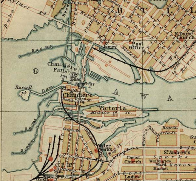 Map of the Chaudière area before the construction of the Chaudière Ring dam in 1908. The 1854 dam between Chaudière Island and Russell Island can be seen in the middle left of the map. The Grand Chaudière Dam is not visible.The impact on timber production owing to the construction of the Grand Chaudière Dam was considerable. Reportedly, the small mill owned by Mr. Young increased its monthly production by 1 million feet of lumber, the product of 5,000 standard logs, during the first dry season after the completion of the dam. Extrapolating these figures to include the much larger operations of Messrs. Baldwin, Bronson, Booth and Perley, the Citizen calculated that a total of 13 million additional feet of lumber were produced every month during the dry season. With a dry season averaging three months, the value of increased production amounted to an estimated $507,000 dollars—a huge sum. As well, there was no flooding during the spring freshet as feared by the government. The expectations of the dam’s backers were more than fully met.
With the mills working at full capacity from the beginning to the end of the milling season, the Citizen wrote: The completion and successful working of the dam may be said to be the crowning point of numerous victories over great natural obstructions and difficulties. The vast water power which has for ages been conserved in the Chaudière Falls, has now been utilized to an extent which few of the last generation ever dreamt of, and which but few of the present generation, who thoroughly understood the difficulties, could, a few years ago, have supposed could be realized.
Today, the Grand Chaudière Dam, which permitted a huge expansion of the Ottawa timber business during the second half of the nineteenth century, is long gone. It was replaced by the Chaudière Ring Dam in 1908 which massively expanded the hydro-electric generating capacity of the Chaudière Falls, and provided the bulk of Ottawa’s electricity during the early twentieth century.
Sources:
Haxton Tim & Chubbuck, Don, 2002, Review of the historical and existing natural environment and resource uses on the Ottawa River, Ontario Power Generation, www.ottawariverkeeper.ca/wp-content/uploads/2014/12/tim_haxton_report.pdf.
Ottawa Citizen, 1854. “No Title,” 29 July.
——————, 1854. “Ottawa Improvements,” 7 October.
——————, 1854. “Public Works On The Ottawa,” 28 October.
——————, 1868. “Inauguration Of The Great Chaudiere Dam,” 23 October.
——————, 1869. “The Pubic Works on the Ottawa And Its Tributaries,” 12 August.
——————, 1869. “The Lumbering Interests Of Ottawa, 16 August.
Ottawa Riverkeeper, 2019. Dams, www.ottawariverkeeper.ca/home/explore-the-river/dams/.
Story written by James Powell, the author of the blog Today in Ottawa's History.
Retired from the Bank of Canada, James is the author or co-author of three books dealing with some aspect of Canadian history. These comprise: A History of the Canadian Dollar, 2005, Bank of Canada, The Bank of Canada of James Elliott Coyne: Challenges, Confrontation and Change,” 2009, Queen’s University Press, and with Jill Moxley, Faking It! A History of Counterfeiting in Canada, 2013, General Store Publishing House, Renfrew, Ontario. James is a Director of The Historical Society of Ottawa.
The Chaudière Bridges
28 September 1826
Bridges are amazing structures. Spanning rivers, gorges, bays and even open ocean, they are testaments to the ingenuity of the engineers who designed them and the courage and ability of the workers who constructed them. Who hasn’t crossed a bridge and wondered what’s holding it up and experienced a frisson of excitement or even terror? The longest bridge in the world over water connects Hong Kong to Macau and the city of Zhuhai on the Chinese mainland, a distance of 55 kilometres, of which a 6.7-kilometre stretch midway is an under-water tunnel between two artificial islands to allow ocean-going ships to travel up the Pearl River estuary. It opened in 2018. Canada’s Confederation Bridge, which links Prince Edward Island to New Brunswick, is 12.9 kilometres long. At the other extreme is Bermuda’s Somerset Bridge that connects Somerset Island with the “mainland.” Dating back to 1620, it is reputedly the smallest drawbridge in the world. Operated by hand, it is just wide enough to allow a mast of a sailboat travelling between the Great Sound and Ely’s Harbour to pass through the gap.
In Canada’s capital, six bridges span the mighty Ottawa River: the Alexandra (or Interprovincial) Bridge; the Champlain Bridge; the Chaudière Bridge; the Macdonald-Cartier Bridge; the Portage Bridge; and the Prince of Wales Bridge (now closed). While the current Chaudière Bridge dates from 1919, it is the site of the first and for a long time the only bridge across the Ottawa River.
The need for a bridge crossing the Ottawa River became apparent after work commenced on the Rideau Canal in the summer of 1826 under the direction of Lieutenant Colonel John By of the Royal Engineers. With only wilderness on the Upper Canada side, workers and supplies had to be ferried across the river from Wright’s Town (later known as Hull) in Lower Canada, the only settlement of any consequence in the region, where labourers were billeted and shops and stores could be had. (American Philemon Wright had founded Wright’s Town in 1804.) As this was unsatisfactory to all, Colonel By and his engineering colleagues decided to build a bridge as quickly as possible, their haste probably encouraged by the approach of winter.
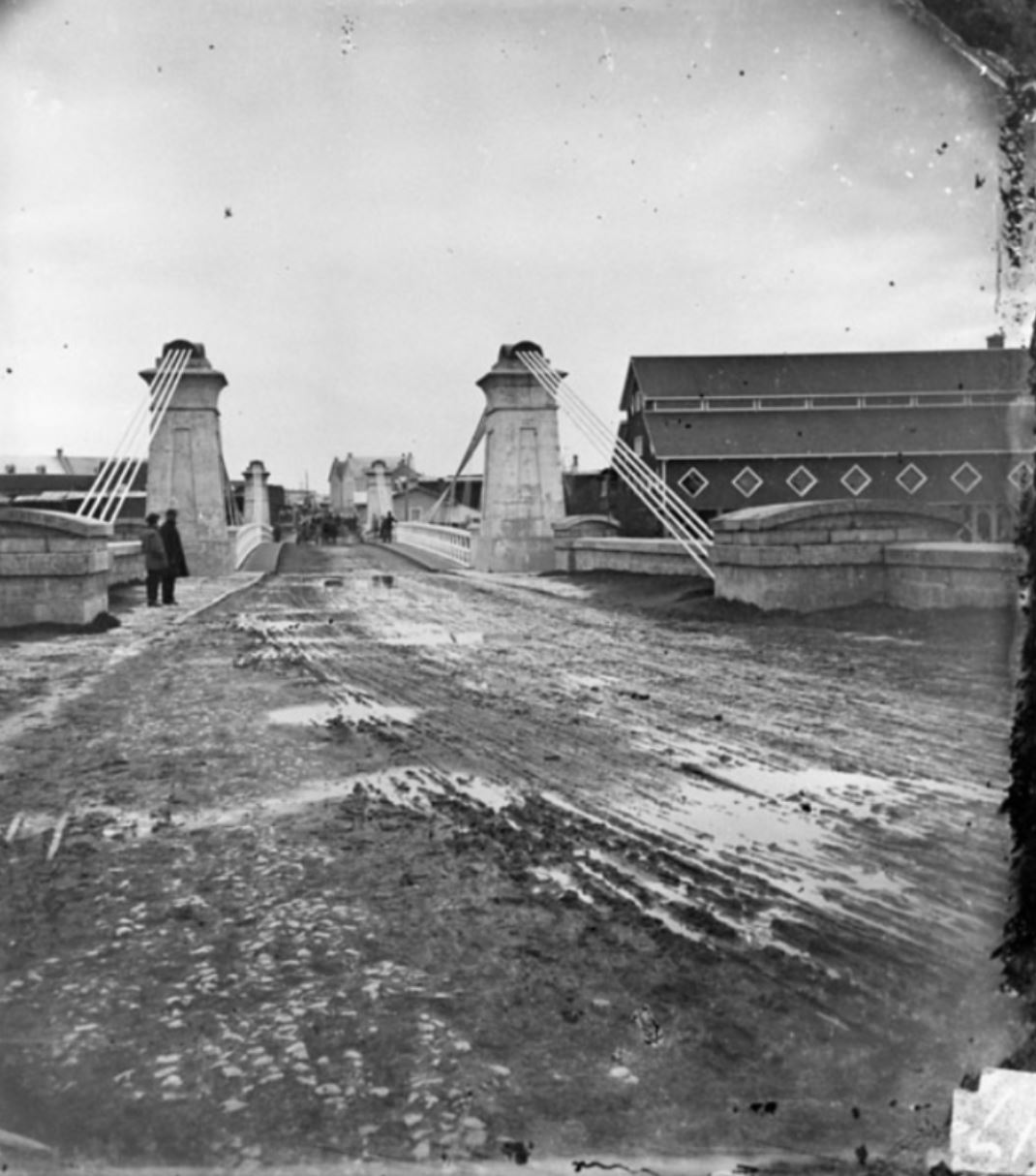
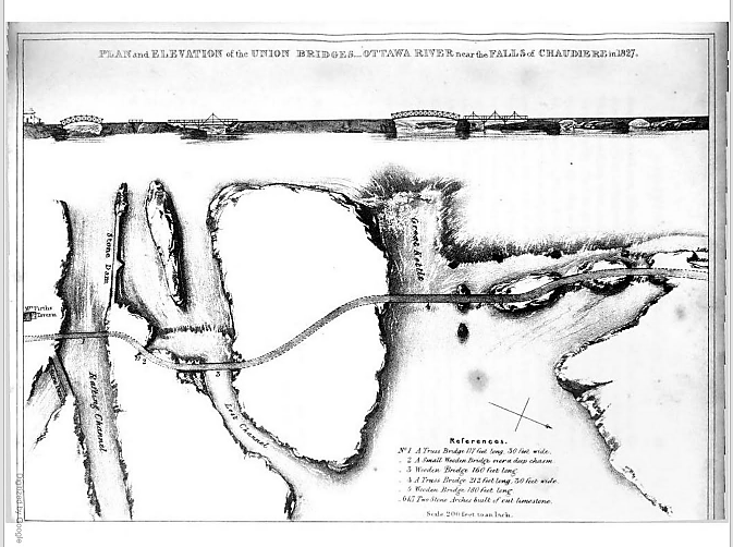 Plan and Elevation of the Union Bridge in Joseph Bouchette, The British Dominions in North America, London, 1832.
Their plan was to build a series of bridges to link Lower Canada on the northern shore of the Ottawa River to Upper Canada on the southern shore at the Chaudière Falls where the river temporarily narrows, using the islands mid-river as stepping stones. All were to be made of stone and masonry except for the widest section which was to be made of wood given the width of the gap, the depth of the water and the speed of the current. Col. By later modified this plan. Five of the seven bridges were made of wood—(from south to north over the river,) a 117-foot truss bridge, a small bridge over a deep chasm, a 160-foot bridge, a 212-foot truss bridge, a 180-foot bridge, and two limestone bridges.
After a quick survey—these were the days long before environmental assessments—construction began. On 28 September 1826, General George Ramsay, 9th Earl Dalhousie and Governor General of British North America, placed several George IV silver coins under a foundation stone on the Lower Canadian shore. Colonel Durnford of the Royal Engineers, Colonel John By, and a number of prominent area landowners, including Nicholas Sparks, Thomas McKay and Philemon Wright, attended the ceremony.
Three weeks into the construction, the first masonry arch on the Lower Canada side collapsed when the temporary supporting falsework was removed. Colonel By ordered work to recommence immediately with new plans drawn up by Thomas Burrowes, the assistant overseer of works. The new, hammered stone arch was completed by early January 1827 despite atrocious working conditions. Spray from the nearby falls froze thickly onto the workers’ clothes despite rough wooden screens being installed to shelter them. The second arch was finished by the summer of 1827.
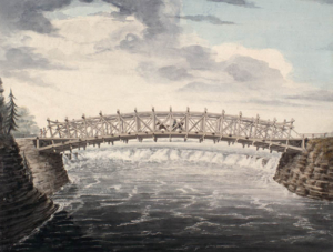
The biggest challenge was bridging the Chaudière itself, also known in English as the Giant Kettle. To link its two sides, Captain Asterbrooks of the Royal Artillery fired a brass cannon loaded with a ½-inch rope to workmen on Chaudière Island. Twice he failed, the rope breaking. But he succeeded with a 1-inch rope. Once workers had a hold of it, they were able to haul over larger cables. Two ten-foot wooden trestles were constructed on either side with ropes stretched over their top and fastened to the rocks. The workers fashioned a precarious footbridge with a rope handrail. It swayed in the wind and sagged to within seven feet of the raging torrent beneath it. It must have been terrifying to cross. In his 1832 book The British Dominions in North America, Joseph Bouchette wrote: “We cannot forebear associating with our recollections of this picturesque bridge the heroism of a distinguished peeress [Countess Dalhousie], who we believe, was the first woman to venture across it.” The bridge’s ropes were then replaced with stronger chains. But as workmen were planking the floor of the bridge, the last step in its construction, disaster struck. First one then the other chain broke, throwing men and their equipment into the raging torrent. While accounts vary, as many as three men drowned.
Undeterred by the tragedy, Colonel By immediately got back to work. This time, workmen constructed stronger trestles and bridged the gap with two 8-inch link chain cables. Two large scows, a type of flat-bottomed boat, were built and moored securely in the location of the bridge. Jack screws placed on the scows supported the bridge during its construction. Unbelievably, just prior to the bridge’s completion, a strong gale flipped it over. Workmen were obliged to cut the bridge free which sent it sailing down the Ottawa river, coming to land close to the entrance of the Rideau Canal. Reportedly, the Chief workman, Mr. Drummond, shed tears in frustration.
Again, Colonel By persevered; his next bridge held. Supported by chains made of 1 3/4-inch thick iron and 10-inch links, the wooden bridge was 212 feet long, 30 feet wide and roughly 40 feet above the water, high enough to escape damage during the spring freshet. It was completed in the summer of 1828, two years after construction had commenced. Upper and Lower Canada were finally united. Fittingly, Col. By called it the Union Bridge.
Lieutenant Pooley, who worked for Col. By, supervised the construction of a final bridge needed to connect Bytown with the new Union Bridge. This bridge spanned a “gully” in what became LeBreton Flats. So impressed was Col. By with Pooley’s round-log bridge that he dubbed it “Pooley’s Bridge.” This name stuck. Lieutenant Pooley’s wooden bridge was replaced by a stone bridge in 1873. It was designated a heritage structure in 1982.
As the Union Bridge was funded by the Imperial Government, Colonel By instituted a toll to help pay for it. The cost was one penny per person, one penny for every horse, ox, cow, sheep and pig, and two pennies for every wagon and sleigh. This was a pretty steep tariff for the times.
Sadly, the Union Bridge did not last. In May 1836, it collapsed into the river and was swept away. Fortunately, there was nobody on it at the time. Again, the only way across the Ottawa River was by ferry.
This all changed in 1843 when the Union Suspension Bridge, constructed by Mr. Wilkinson, an American, opened for traffic. The bridge had a span of 242 feet. Its iron wire suspension cables, which were imported from Britain to Montreal and ferried to Bytown in barges, supported an oaken plank deck. It was the first of its kind in Canada, and was considered an engineering marvel of the age. The Packet opined that the bridge was “a beautiful piece of work” and that it “reflects great credit to the builder, Mr. Wilkinson.” A big celebration was held at Doran’s Hotel on Wellington Street to mark its opening. Engraved invitations were sent out to guests to attend the “Union Suspension Bridge Ball,” complete with a picture of the completed bridge.
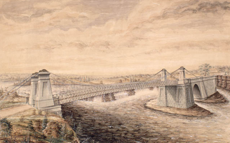 Union Suspension Bridge, Watercolour by F. P. Rubidge, Library and Archives Canada, Arch. Ref. R182-2.
Like its predecessor, the Union Suspension Bridge charged tolls. It was a profitable business. In the June to September period of 1851, Duncan Graham, appointed the (tax) Collector for Bytown in the Finance Department by Earl Cathcart, collected £303. 6s. 7d. (equivalent to more than $1,650) in tolls. This was almost enough to cover his annual salary of $1,500 and the monthly stipend £6. 5s. of Mr Mossop, the bridge keeper, who lived in the toll house rent free. Later, the government put the toll business out to tender. At the 1869 tender, the government set a reserve price of $2,000. This compares with annual tolls collected in the 1865-1868 period ranging from $2,500 to $3,350. The winner of the auction was required to maintain the toll house, and keep the bridge clean of rubbish. In winter, they were also responsible for snow clearance, but were required to leave six inches to facilitate sleigh traffic.
Bridge maintenance was not up to everybody’s standards. People complained that the bridge was dangerous especially at night as its railings were low and weak. “Persons run a very great risk on a dark night of driving into the ‘Devil’s Punch-bowl’” said the Ottawa Citizen. As well, the approaches to the bridge on either side of the river were nearly impassable during rainy weather owing to “the enormous quantity of mud and water collected.” In an agreement with the City, the Dominion government abolished tolls on the Union Suspension Bridge in 1885.
 The muddy and rutted entrance to the Union Suspension Bridge, looking towards Ottawa, Topley Studio, c. 1867-70, Library and Archives Canada, PA-012705.In 1889, the Dominion government appropriated $35,000 for a new iron truss bridge to replace the deteriorating Union Suspension Bridge. Messrs. Rousseau & Mather were the contractors. Work commenced at the beginning of August and was completed by the beginning of December of that year. Many were concerned that the 30-foot width of the new roadway was too narrow given the growing amount of traffic between Ottawa and Hull. Appeals to the government to widen the bridge or at least put the two 5-foot sidewalks on the outside of the trestles in order to increase the width of the roadway by 10 feet fell on deaf ears.
Twelve years later in 1900, the Great Fire, which destroyed much of Hull and LeBreton Flats, severely damaged the bridge. A vital thoroughfare, the government moved quickly to repair it.
In 1919, the Government condemned the Chaudière bridge as being unsafe. According to the Citizen, just walking over the old bridge was enough to give one “thrills” owing to its “see-saw motion when cars pass over it.” Dominion policemen ensured that too many vehicles didn’t try to cross the bridge at the same time. The replacement bridge was built by the Dominion Bridge Company at a cost of $110,000. It was assembled on the Quebec side and was moved into place using scows. This time, government listened to its critics, and placed the sidewalks on the outside of the piers. Before the new Chaudière bridge was put into position, the old bridge was lifted by four 50-ton hydraulic jacks, placed on rollers, and moved 50 feet downriver to a temporary location so that traffic across the river would not be unduly impeded by the construction.
In 2008, the Chaudière bridge was temporarily closed when an inspection revealed that its stone arches, some of which date back to that first 1820’s bridge, were no longer safe. Following repairs, the government reopened the bridge the following year. It continues to serve thousands of commuters every day.
Sources:
Bouchette, Joseph, 1832. The British Dominions in North America, Vol. 1, London: Longman, Rees, Orme, Brown, Green and Longman.
Bytown Gazette, 1846. “No title,” 14 September.
Canada, Province of, 1867. Report of the Minister of Agriculture for 1866, Ottawa: Hunter, Rose & Company.
Mika, Nick & Helma, 1982. Bytown, The early day of Ottawa, Belleville: Mika Publishing Company.
Ottawa Citizen, 1868. “Editorial,” 19 June.
——————, 1869. “Tolls on Union Suspension Bridge,” 26 July.
——————, 1908. “Civil Servants’ Income Tax,” 17 February.
——————, 1919. “Chaudiere Bridge Gives One Thrills,” 18 August.
——————, 1919. “Are Moving The Old Chaudiere Bridge,” 21 August.
——————, 1929. “Ottawa’s First Bridge And Other Narrations,” 12 October.
——————, 1933. “Chaudiere Toll Bridge 1851, Document Tells of Revenue,” 5 August.
——————, 1981. “By-Gone Days,” 28 February.
Ottawa Journal, 1889,” Supplementary Estimates,” 24 April.
——————, 1889. “The Chaudiere Bridge,” 19 September.
Packet (The), 1847. “The Ottawa-Slides-Steamers-Railroads-Necessary Improvements, etc.” 12 June.
Story written by James Powell, the author of the blog Today in Ottawa's History.
Retired from the Bank of Canada, James is the author or co-author of three books dealing with some aspect of Canadian history. These comprise: A History of the Canadian Dollar, 2005, Bank of Canada, The Bank of Canada of James Elliott Coyne: Challenges, Confrontation and Change,” 2009, Queen’s University Press, and with Jill Moxley, Faking It! A History of Counterfeiting in Canada, 2013, General Store Publishing House, Renfrew, Ontario. James is a Director of The Historical Society of Ottawa.
Strike! En Grève!

14 September 1891
For the majority of people in Canada during the nineteenth century, life was hard. If you managed to avoid the myriad of killer diseases that prematurely snuffed out the lives of many, you could look forward to long hours of backbreaking work, regardless of whether you lived on a farm, or in one of Canada’s growing urban centres, such as Ottawa. In the sawmills and lumber yards of the Chaudière, the typical work day started at 6am and finished at 6pm, with an hour off for dinner; often people were forced to work much longer. Sunday was the only day of rest. Wages were low. According to an 1886 Royal Commission, domestic servants earned $6-8 per month, with room and board. Adult male workers at John R. Booth or Erskine Bronson’s sawmills brought home $1.00-1.50 per day, while women doing piece work in Ezra B. Eddy’s match factory in Hull could look forward to the munificent income of $0.35-0.75 per day. Boys and girls earned a pittance. Fortunately, prices were much lower than today. Very roughly, a weekly wage of $7.00-$9.00 might be equivalent to $150-200 per week today. But work was often seasonal; the sawmills and lumberyards of the Chaudière closed during the winter.
Working conditions were also poor. Accidents on the job maimed or killed many each year at a time when there was no workmen’s compensation. If you couldn’t work, you weren’t paid. Match workers, usually women or girls called allumettières, faced the horrible prospect of contracting phossy jaw, the colloquial term for phosphorus necrosis, through their exposure to white phosphorus used to make match heads. Phossy jaw caused terrible jaw abscesses, organ failure, brain damage, and, ultimately, death. Respiratory disease was rampant among lumber workers who laboured in poorly-ventilated, dusty sawmills. Sawdust, dumped into the Ottawa River, polluted the water on which residents relied. In the cramped, unhygienic, wooden shanties constructed on LeBreton Flats and in Hull close to the Chaudière mills and lumberyards, typhoid and other waterborne diseases flourished.
In the late nineteenth century, mutual aid societies, co-operatives, and unions emerged with the objective of improving the lives of working people, a development encouraged by the passage of the Trade Unions Act of 1872 by the government of John A. Macdonald; hitherto, union activity had been viewed as illegal conspiracy. Early unions active in Ottawa included the Canadian Labour Protective Association (1872) and the Canadian Labour Union (1873). Also prominent were the Knights of Labor, an American union and political movement that had begun in 1869 as a secret society. Although the movement had its dark side in the United States, where it was involved in anti-Chinese riots in the west, it was progressive in other respects, supporting gender equality, and equal pay for equal work. It also welcomed black members, though it condoned segregation in the U.S. south. By the 1880s, it had hundreds of thousands of members, and had opened branch assemblies in Canada, including in Ottawa and Hull, despite opposition from the Catholic Church.
The Knights of Labor were prominent in the great Chaudière strike that began on 14 September 1891. For the next month, lumbermen and sawmill workers staged an impromptu and illegal labour walk-out over a pay cut unilaterally imposed by the lumber barons. The strikers also wanted a reduction in their long working hours. While strikes were legal back in those days, six months’ notice had to be provided to management. Napoléon Pagé, a journalist who had started the Hull assembly of the Knights known as the Canadienne, was a prominent strike leader, though the Knights of Labor never endorsed the strike given the legal requirements to call a walk-out; they officially favoured arbitration. Nonetheless, Pagé’s newspaper, Le Spectateur, became the voice of the striking workers. Also prominent among the leadership of the mill and lumber workers was J. W. Patterson, head of the Ottawa Trades and Labour Council, and Napoléon Fateux (or Fauteux). Fateux, a mill worker, was a particularly effective leader, counselling restraint and peaceful assembly. He warned against mixing strike activity with alcohol, and urged older workers to curb young hotheads.
1891 was a bad year for the Canadian lumber industry. Important markets in Britain and South America were weak owing to a global economic recession; the previous year, an international financial crisis had erupted when Baring Brothers, an important British banking house with a global reach, almost collapsed owing to huge losses on its investments in Argentina. The company was famously rescued by the Bank of England. In response to weak demand and low lumber prices, the Chaudière lumber barons cut the weekly wages of sawmill workers by 50 cents. They also failed to live up to an earlier promise to reduce the work week to ten hours. When George Pattee refused a demand from workers at the Perley & Pattee Lumber Company to restore the 1890 wage rate, on the grounds that he was only following the policy set by the lumber industry, his workers struck. Quickly, workers at other sawmills and lumberyards downed tools. At its greatest extent, some 4,000 workers had walked off the job—a huge proportion of Ottawa-Hull’s population, which perhaps totalled 50,000 at that time. Large public meetings were held in both Hull and Ottawa, attracting many thousands of people.
The strike was marred by violence and intimidation on both sides. On 15 September, more than two thousand workers marched from the wharf opposite the Booth mill in Ottawa across the Union Bridge to the Eddy match factory. There, the strikers confronted Ezra Eddy himself and other managers. A man, identified by the sobriquet “Red Moustache” violently kicked Eddy in the stomach before the mob dispersed. Later that same day, C.B. Wright, a sawmill owner, told a delegation of strikers that he was prepared to defend his mills “at the rifle muzzle if necessary.” Subsequently, Mr. Ruggles Wright fired blank rifle shots at workers in an attempt to intimidate them. In the ensuing affray, C.B. Wright was injured. There was more violence at the Mason family mill, where the father was roughed up, and his two sons, William and George, were cut by thrown stones.
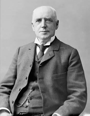 Ezra Eddy, 1827-1906, Owner of E.B. Eddy Company and sometime Mayor of Hull, Quebec
Library and Archives Canada, MIKAN no. 3468801Ezra Eddy, who was also the mayor of Hull, persuaded two justices of the peace to call out the militia. Two companies of the Governor General’s Foot Guards and two companies of the 43rd Battalion were called up to report to the Drill Hall at 5am on 16 September. The part-time troops, who were mostly civil servants, were armed with bayonets and live ammunition, though their commander, Lt-Col. Anderson, warned them not to take offensive measures without the command of their officers. The soldiers marched from the Drill Hall to Eddy’s in Hull, where two companies were deployed to avert trouble; the remaining two companies were stationed at the Hurdman sawmill. Fortunately, nothing happened. The strikers remained peaceful, and the soldiers were quickly demobilized after a workers’ delegation, which included Napoléon Fateux and J. W. Patterson, convinced Ezra Eddy that the troublemakers were not mill men, but outsiders. The workers’ delegation also promised to assign men to protect private property.
This was not the end of the violence, however. At the end of the month, there was a serious clash at the Perley & Pattee Company when strikers attempted to stop lumber shipments leaving the mill. Chief McVeity of the Ottawa police force and his men responded with batons “in a lively style,” according to The Ottawa Evening Journal. Striking workmen responded by throwing stones and sticks. Serious injuries were averted by the timely arrival of Napoléon Fateux who succeeded in restoring peace. The ferocity of the police response led public opinion, which already broadly supported the strikers, to swing even more in their favour.
Church, civic groups, small merchants, and individuals contributed money and goods to help families of the strikers. At the peak, more than 200 families were being helped daily. Special shops for strikers were established in Place du Portage in Hull and in LeBreton Flats. Strike relief funds were also provided by other unions, both in the Ottawa area and outside, though the amounts raised were small.
By early October, cracks in the owners’ façade were beginning to show, especially after an attempt to use scab labour brought in from Pointe Gatineau failed when striking workers persuaded strike breakers to desist. As one brought-in worker explained, it was “better to stop work and live a little longer.” On 3 October, work resumed at the Hurdman mill in Hull. While the owners had not budged on pay, they instituted a ten-hour work day.
But the workers were also at the end of their tether. On 12 October, more than 1,100 men returned to work on the old terms; that is to say, no raise and no ten-hour day. More followed. As the Journal put it, “men were, with scarcely an exception, heartily weary of hanging around doing nothing, with empty pockets, on the threshold of winter.” Although most mill owners had provided no concessions, rumours of change were rife. The following day, Perley & Pattee reversed the 50 cent reduction on the face-saving grounds that the men had returned to work of their own free will. The other lumber companies quickly followed suit.
By the time the strike ended, at least 1,000 experienced millworkers and lumbermen, short of money, had left Ottawa-Hull. Some 600 went to the Saginaw region in Michigan, which had its own lumber industry. Consequently, the Chaudière lumber companies had difficulty in quickly restoring full operations. With the balance of power shifting towards the workers, the ten-hour work week was finally implemented in 1895.
Sources:
Kealy, Gregory S. 1995. Workers and Canadian History, Montreal and Kingston: McGill-Queen’s University Press.
Martin, Michael, 2006. Working Class Culture and the Development of Hull, Quebec, 1800-1929.
Morton, Desmond, 1998. Working People: An Illustrated History of the Canadian Labour Movement, Montreal and Kingston: McGill-Queen’s University Press.
The Ottawa Evening Journal, 1891. “Violence,” 15 September.
————————, 1891. “Strikers’ Meeting,” 15 September.
————————, 1891. “The Strike,” 16 September.
————————, 1891. “Nothing Done,” 17 September.
————————, 1891. “Hard Knock,” 30 September.
————————, 1891. “Work Stopped,” 1 October.
————————, 1891. “Buzzing Again,” 12 October.
————————, 1891. “”Back to Work,” 13 October.
————————, 1891. “50 Cents More,” 13 October.
National Capital Commission, 2013. “Donalda Charron and the E.B. Eddy Match Company: Working Conditions,” Virtualmuseum.ca.
Images: Knights of Labor.
B. Eddy, Library and Archives Canada, PA25792.
Story written by James Powell, the author of the blog Today in Ottawa's History.
Retired from the Bank of Canada, James is the author or co-author of three books dealing with some aspect of Canadian history. These comprise: A History of the Canadian Dollar, 2005, Bank of Canada, The Bank of Canada of James Elliott Coyne: Challenges, Confrontation and Change,” 2009, Queen’s University Press, and with Jill Moxley, Faking It! A History of Counterfeiting in Canada, 2013, General Store Publishing House, Renfrew, Ontario. James is a Director of The Historical Society of Ottawa.
Quick Links
About
Supporting Partners