Working to preserve Ottawa's past
for future generations.
André Pinard – Colonel By and the Founding of Bytown
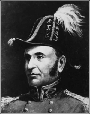
Who better to share the story of the Bytown’s beginnings than Lt. Colonel John By himself? Who more reliable to recount the construction of the Rideau Canal than the Royal Engineer who had overseen this remarkable project?
André Pinard constructs what an interview might have been like, between Colonel By and a newspaper editor, at the conclusion of construction of the Rideau Canal.
As an added bonus, André presents this fictive conversation in the form of scripted play. What a wonderful opportunity for educators who might wish offer students a glimpse into Ottawa’s past by re-enacting this play in their classrooms.
André Pinard is originally from Ottawa’s Lower Town. André pursued a career in education in Northern Ontario and the Ottawa region.
Colonel By and the Founding of Bytown
By André Pinard
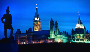
This fictive conversation takes place on September 3, 1832, in the sitting room of Lieutenant-Colonel John By ’s residence on Nepean Point, overlooking Entrance Bay and the Rideau Canal at Bytown.
He is being interviewed by Thomas Dalton, editor of The Patriot and Farmer ’s Monitor, a Kingston weekly newspaper.
Mr. Dalton: Good afternoon, Sir.
Colonel By: A very good afternoon to you. It is a pleasure to make your acquaintance. How does Kingston prosper of late?
Mr. Dalton: Kingston fares well, I thank you. Since the completion of the canal, it has prospered in many ways. The town is alive with soldiers, merchants, canal workers, and settlers, and I daresay it has grown considerably in strategic importance in recent years.
Colonel By: Quite so. I am pleased to hear it.
Mr. Dalton: Thank you, Sir, for receiving me in your handsome home overlooking Entrance Bay and the Rideau Canal. You command a splendid prospect indeed.
Colonel By: From this vantage, I can observe the batteaux and paddle boats as they arrive and depart, and thus keep myself apprised of local affairs. You must, however, pardon the state of the house; we shall be leaving for England very shortly.
Did you travel from Kingston by way of the canal?
Mr. Dalton: Indeed I did, Sir, aboard the now-famous paddle boat Pumper. What a prodigious work the Rideau Canal is—a remarkable feat of engineering and a lasting testament to British ingenuity and perseverance. I was overwhelmed by the number of great dams and locks—here at Entrance Bay, at Hog’s Back, at Jones Falls, and elsewhere besides. And its length, Sir—truly astounding.
Colonel By: Most assuredly. The canal extends some 123 miles from Bytown to Kingston and comprises 52 dams and 47 masonry locks, all completed within five summer working seasons. It reflects not only British expertise, including that of the Royal Sappers and Miners, but also the tireless labour of more than 2,000 Irish, Scots, and French Canadian labourers and tradesmen. Many worked in the harshest conditions, and many, regrettably, lost their lives through sickness or accident.
Mr. Dalton: I understand that you yourself made the first official passage through the completed canal last May.
Colonel By: I did indeed have that honour, sailing from Kingston Mills to Bytown aboard the steamship Pumper, renamed Rideau for the occasion. It was a memorable event, and we were greeted warmly at every lock, with much rejoicing and ceremony.
Smiths Falls, in particular, left a strong impression. We arrived there near four o’clock in the morning, announcing our presence with a cannon shot, which the townspeople promptly returned. As the crowd gathered along the dock, we disembarked to greet them, and upon our departure received a final salute. The experience made a deep impression upon our young daughters, who accompanied my wife and me on this inaugural voyage.
Mr. Dalton: Why was the Rideau Canal built?
Colonel By: The canal was conceived as a military necessity for the defence of Upper Canada. Kingston’s fortress and naval yard were vital to British control of the Great Lakes, yet supply by way of the St. Lawrence River was both difficult and vulnerable to American attack, given the river’s proximity to the United States border.
An inland route was therefore required to move troops, artillery, and supplies securely between Montreal and Kingston. By 1825, a canal linking the Ottawa River to Lake Ontario was deemed essential to the colony’s defence.
Mr. Dalton: There was much sickness among the workers, I understand?
Colonel By: Indeed there was, and no man was spared. Disease was widespread throughout the works. Swamp fever, ague, dysentery, and smallpox afflicted labourers and their families alike. I myself suffered repeated bouts of fever and was bled on two occasions. Quinine was the sole effective remedy, though its cost and scarcity limited its use. In 1828, an epidemic proved so severe that work was temporarily halted. Losses from illness and accident were grievous, and it is estimated that nearly one thousand lives were lost during the undertaking.
Mr. Dalton: Why was Entrance Bay chosen over Lebreton’s Flats, or a route east of the Rideau Falls, as Samuel Clowes had proposed?
Colonel By: Mr. Clowes’s route was carefully considered, but it would have required extensive blasting through solid rock. We therefore selected Sleigh Bay, which offered greater defensibility and proved far easier to excavate, being composed largely of sand and gravel.
Mr. Dalton: And why not select Captain John Lebreton’s property at Richmond Landing?
Colonel By: Quite frankly, it would have offered a shorter and easier approach to Dow’s Great Swamp. However, the Earl of Dalhousie would not entertain the idea. His dispute with Captain Lebreton over the price of the land rendered it impossible.
Moreover, His Excellency had already acquired, as early as 1823, the lands adjoining the present canal site from Barrack’s Hill eastward—excluding Lebreton’s property, which was considered excessively dear.
Mr. Dalton: Bytown bears your name, Sir. You are said to be its founder.
Colonel By: I am honoured by the association, though it might with equal justice have been named Dalhousie, in recognition of His Excellency’s leadership and steadfast support. Without him, neither the canal nor the town would have come to fruition.
At first, in 1826, we referred to the area simply as the Rideau Canal. Then, partly in jest, someone proposed the name By’s Town. Much to my surprise—and protest—it soon became Bytown. For the present, the name endures, though I expect that, as the town grows in size and consequence, it will one day adopt a name more fitting to its geography and history.
This place has borne many names already—Îles aux Chaudières, Barrières, Place des Rideaux, Chaudière Falls, The Point, Richmond Landing, Bellows Landing, and Nepean. The possibilities are many.
Mr. Dalton: Before Bytown was established, were there already people living here?
Colonel By: Most certainly. The Hurons, Algonquins, and Iroquois travelled and traded along this great river, which they called Kitche-sippi, for countless generations. They were the first to behold the Rideau Falls and to portage around the Chaudière. In the days of Cartier and Champlain, it was known as the River of the Algonquins.
After a long and bitter struggle between the Algonquins and the Iroquois over trade, the river lay deserted for many years. In 1654, the Outaouais—members of the Algonquin nation—returned to trade here, and from that time the river has borne the name Ottawa.
Mr. Dalton: And your relations with the local tribes?
Colonel By: They are cordial. The Algonquins often serve as guides and willingly share their knowledge of the land. At the same time, they continue to petition the government to recognize their land claims. That matter remains unresolved and lies beyond my authority.
Mr. Dalton: How long have settlers of European origin been present in this region?
Colonel By: Settlement in the valley began in earnest after 1791. In 1793, four townships—Osgoode, North Gower, Gloucester, and Nepean—were established, forming part of Carleton County. When I arrived seven years ago, development here was minimal. There were but two stores, one stone building, three square timber houses, and a handful of cabins.
Among the early inhabitants were men whose names you may recognize: Nicholas Sparks, John Bellows, and John Lebreton. Although settlements existed farther inland—such as Richmond, a military settlement founded in 1818—there was little activity along this stretch of the river.
Mr. Dalton: And the northern shore?
Colonel By: There the situation is quite different. A community has existed since 1800, founded by Philemon Wright, who arrived from Massachusetts with his family and labourers. He has since become a successful timber merchant, sending great quantities of white pine downriver to Quebec, whence it is shipped to Britain. The population now numbers some one thousand.
Mr. Wright proved indispensable to our efforts, supplying materials and practical knowledge of building in the wilderness. So vital was his assistance that one of my first instructions from the Governor was to construct a bridge over the Chaudière Falls. Completed promptly, it was named the Union Bridge, linking Upper and Lower Canada.
Mr. Dalton: How did you come to be entrusted with the creation of this town and the canal?
Colonel By: I am an officer of the Royal Engineers. I was first dispatched to Canada in 1802, where I oversaw the construction of a canal at Les Cèdres and worked on the fortifications of Quebec. In 1811, I was called to Portugal and served under Wellington and Dalhousie during the Peninsular War. Upon my return to England, I was placed in charge of an armament factory. In March 1826, I was selected to undertake the construction of the Rideau Canal.
Mr. Dalton: You arrived here in September 1826. What were those first days like?
Colonel By: In mid-September, I travelled from Montreal to Wright’s Town with Lieutenant Pooley and a small advance party, including the master stonemason Thomas McKay. We examined the south shore, inspecting bays and the mouth of the Rideau River to determine the most suitable site for the canal’s entrance.
On September 26, Lord Dalhousie joined us. After reviewing my recommendations, he approved Entrance Bay as the canal’s northern terminus, and work commenced at once.
Mr. Dalton: Tell me of the men who worked on the canal.
Colonel By: Thousands laboured at sites throughout the route—Royal Sappers and Miners, contractors, tradesmen, and labourers. The Ordnance supplied provisions at cost, while local farmers furnished meat and produce. Log cabins were erected at many sites, and some families maintained small gardens. At the outset, however, many men lived in tents or in crude shelters dug into the earth. Those were trying times indeed.
Mr. Dalton: And what is Bytown like today?
Colonel By: It remains very much a town in formation. The canal has been delivered as promised, yet the reputation of Bytown as “not a handsome town” is not entirely undeserved. Tensions between Irish and French labourers persist, and there is, regrettably, a good deal of disorder.
Mr. Dalton: You are soon to depart Canada. What lies ahead?
Colonel By: I intend to retire to my estate near Frant, in Sussex, with my wife, Esther March, and our two daughters, Esther and Harriet. First, however, I must answer questions from the British Treasury regarding the expenditures incurred during construction.
Mr. Dalton: How were the canal’s costs originally determined?
Colonel By: The Duke of Wellington approved the canal in 1818 as part of the colony’s defensive strategy. To avoid excessive scrutiny, the project was begun with minimal funding. The initial estimate—£169,000—was wholly inadequate, though I was obliged to proceed.In 1827, I submitted a revised estimate of £474,000. By the canal’s completion six years later, the total cost had risen to £822,000—a sum I believe fully justified.
Mr. Dalton: Finally, Sir, of what are you most proud, and what do you wish for Bytown and the canal?
Colonel By: I take pride in my service, but above all in the people—French, Irish, Scottish, and British—who laboured here between the Rideau and the Chaudière. Many gave their lives. It is my earnest hope that their sacrifice will not have been in vain; that Bytown will continue to grow and prosper; and that the Rideau Canal will one day be recognized as the jewel it truly is.
Mr. Dalton: I thank you and bid you good day, Sir, and Godspeed.
Final historical note
Colonel By handed over command to Captain Bolton on September 1, 1832, and then travelled with his family to Québec City. He departed Canada on October 21, 1832, arriving in England on November 25. Although cleared of questions regarding the canal’s cost, he suffered a setback in his career and spent his final years in retirement. His greatest achievement received widespread recognition only after his death, on February 1, 1836, at his Sussex estate. He never saw his work on the Rideau Canal fully celebrated in his lifetime.
Bibliography
Brault, L., Ottawa Old and New,Ottawa Historical Information Institute, 349 pp., 1946.
Brault, L., The Mile of History, Ottawa, National Capital Commission, 83 pp., 1981.
Historical Society of Ottawa, Lt. Colonel John By, Ottawa, 12 pp., Undated.
Ian R. Dalton, “DALTON, THOMAS,” in Dictionary of Canadian Biography , vol. 7, University of Toronto/Université Laval, 2003–, accessed December 23, 2025, https://www.biographi.ca/en/bio/dalton_thomas_7E.html.
Kelsey, E.S., Le colonel By et son époque/ Colonel By and Bygone Days, La Société historique d’Ottawa, 28 pp., 1969.
Lamoureux, G., Bytown et ses pionniers canadiens-français, 1826-1855, Ottawa, 364 pp., 1978
Legget, R., John By, Builder of the Rideau Canal Founder of Ottawa, Historical Siety of Ooawa, 62 pp., 1982.
Leggett, Robert, Ottawa Waterway, Gateway to a continent, University of Toronto Press, Toronto., 1975.
MacTaggart, J., Three Years In Canada,Henry Colborn, London, 2 vols., 347 and 340 pp., 1965.
Mika, Helma and Nick, Bytown, The early days of Ottawa , Mika Publishing Company : Belleville., 1982.
Passfield, Robert, W.,Building the Rideau Canal, A pictorial history . Fitzhenry and White : Markham., 1982
Ross, A.H. D., Ottawa Past and Present,Thorburn and Abbott, Ottawa, 224 pp., 1927.
Note: In the final stages of preparation, the author made use of AI-assisted language tools for spelling, grammar, and stylistic refinements. The research and interpretation presented in this article are entirely the author ’s own.
Ottawa Olde Forge Rug Hooking – Bytown200 Challenge
What a spectacular and creative way to help chronicle two centuries of Ottawa history!
We were thrilled when the enthusiastic members of the Ottawa Olde Forge Rug Hooking group approached the Historical Society of Ottawa in the fall of 2025, eager to join in answering the call and doing their part for the HSO 2026 Bytown200 Bicentennial Storytelling Challenge.
The history of rug-hooking, dating back to the same era as the birth of Bytown and the start of the Rideau Canal, was launched by creative crafters making use of scrap materials leftover in weaving mills in the UK and eventually here in North America.
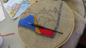
The Bytown200-themed projects being artfully crafted by Ottawa Old Forge Rug Hooking members were displayed at City Hall on Heritage Day, February 17, 2026, and are photographed and shared here on the HSO Bytown200 web page.
Below find samples of a few of their works – ranging from concept to completion.
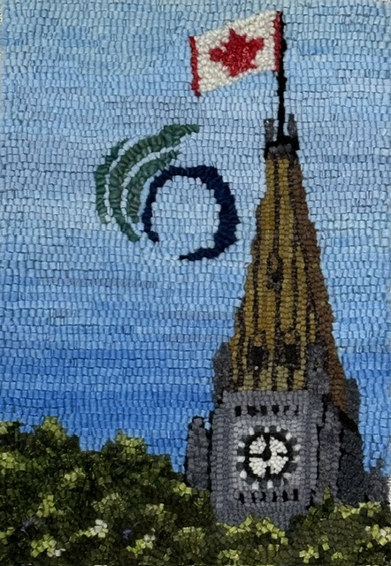
Pauline Mantha: The Peace Tower
Alongside the Peace Tower is Pauline's rendition of the City of Ottawa's stylized "O" with its streamers subtly suggestive of both the maple leaf and the Parliament Buildings, and symbolizing unity and harmony.
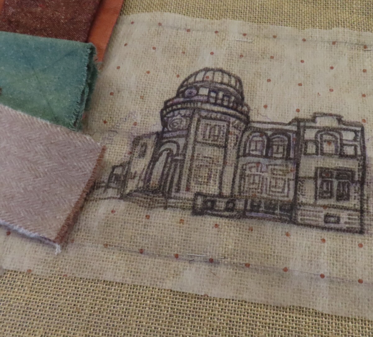
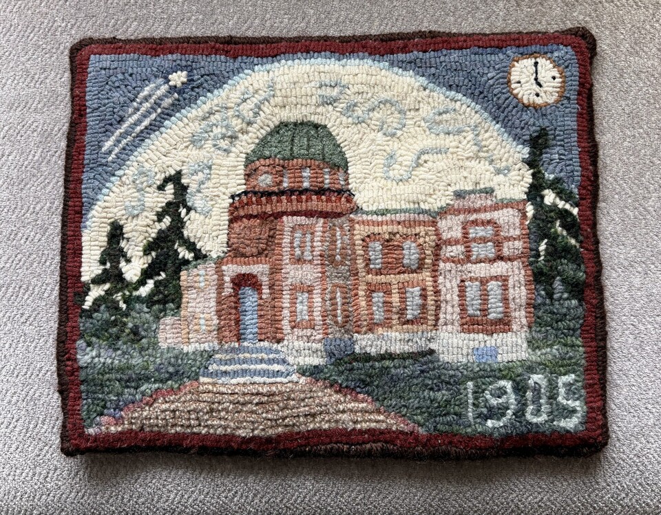 The Dominion Observatory by Pat Bonn.
The Dominion Observatory
The Dominion Observatory was built on the Experimental Farm in 1905, in answer to the increased requirements of the Geographic Survey of Canada mapping and topographic surveys.
The 35 cm telescope’s larger size improved:
- temporal star readings : resulting in one national high precision clock (needed for railway schedules) . It was called the Dominion Observatory Time.
- spacial star observations: allowing more precise longitude, latitude and elevation readings (needed for establishing accurate provincial and international borders).
Additional instruments measuring seismic (earthquakes), gravimetric and magnetic geophysical data were also housed in the same location.
In 1992, the Dominion Observatory was recognized as a Federal Heritage Building for its architectural (Romanesque and Revival style) and historic value.
Pat Bonn worked 29 years for Agriculture Canada as a Research Technician.
Read more about the Dominion Observatory in James Powell's story Today in Ottawa's History - The Dominion Observatory.
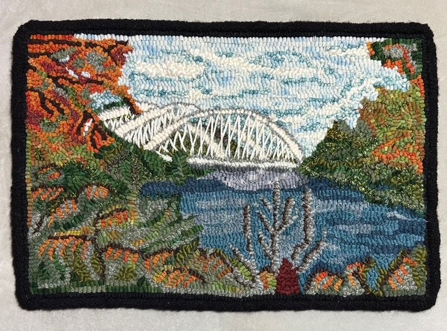
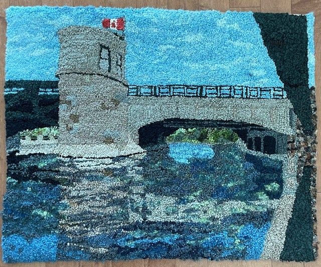 Pretoria Bridge by Lara Wellman
Lara Wellman : Pretoria Bridge
Aside from the Parliament Buildings, few landmarks are as iconic to Ottawa as the Rideau Canal. Built in 1915, Pretoria Bridge connects the Glebe with what was once known as Ottawa East. Now designated as a heritage structure, it stands as a cherished landmark that will continue to be enjoyed by Ottawans for generations to come.
Designed and hooked by Lara Wellman in 2024. Wellman was inspired to create this piece as a symbol representing her city.
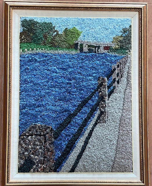 View of the Rideau Canal by Lara Wellman
Lara Wellman : View of the Rideau Canal
Aside from the Parliament Buildings, few landmarks are as iconic to Ottawa as the Rideau Canal. This view of the canal is looking towards the Golden Triangle. The Bridge is for the Queensway to cross the canal.
Designed and hooked by Lara Wellman in 2023. Wellman was inspired to create this piece as a symbol representing her city.
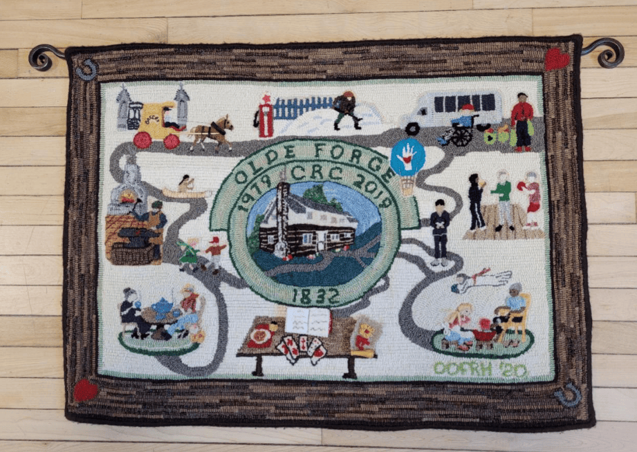 Olde Forge Community Resource Centre by members of the Ottawa Olde Forge Rug Hooking group.
Olde Forge Community Resource Centre 40th Anniversary Commemorative Rug
The Olde Forge is an historic building in Ottawa’s west end, found just west of the junction of Carling Avenue and Richmond Road. Members of the Ottawa Olde Forge Rug Hooking Group made this rug to commemorate the 40th anniversary of the current residents of the Olde Forge, the Olde Forge Community Resource Centre. From its first role as a blacksmith’s shop and family home in 1832 to, decades later, a restaurant/tearoom, taxi service, gas station, tourist centre and, since 1980, a community resource centre, the building at the centre of the rug provided a wealth of inspiration for the rug’s design.
The original owner and builder of the Olde Forge, George Winthrop, is said to have arrived in Bytown from Montreal by canoe in 1832, much like Colonel By six years earlier and just as First Nations peoples had travelled since time immemorial. He built the log building and forge and ran a thriving business for many decades. The growing town of the era would have had a high demand for horseshoeing, wagon repairs, gates and many other implements made of iron. Fittingly, in 1992, it was designated a heritage property under the Ontario Heritage Act.
The rug hooking group took their name from the building where they first held regular meetings. It took an estimated 250+ hours of effort by 24 volunteers to plan and complete the rug in 2020. Nora Lee organized its design and construction, and Pat Bonn did most of the design. The story of the making of this rug was published in Rug Hooking Magazine in 2024.
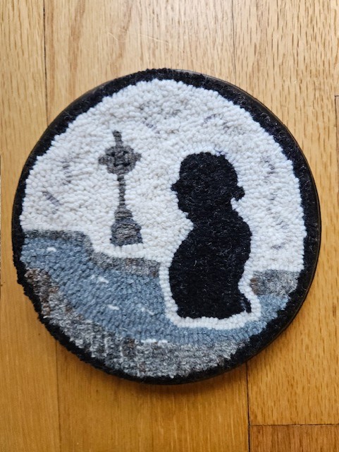 Colonel By and the Memorial Cross overlooking the Rideau Canal by Nora Lee
Nora Lee: Colonel By and the Memorial Cross overlooking the Rideau Canal
Colonel John By of the Royal Engineers supervised the construction of the Rideau Canal. The construction was done by thousands of Irish, Scottish and French-Canadian labourers during the years 1826 to 1832. Conditions were harsh and both accidents and disease, notably malaria, killed about a 1000 workers and their families. The Rideau Canal Memorial Cross was unveiled in 2004. It can be found in Colonel By Valley, next to the canal below Major's Hill Park.
 Vimy Memorial Bridge by Carol Pugsley
The Vimy Memorial Bridge—formerly known as the Strandherd–Armstrong Bridge—is a major modern crossing in Ottawa, completed in 2014. Spanning the Rideau River, it links Strandherd Drive in Barrhaven with Earl Armstrong Road in Riverside South, significantly improving east–west connectivity in the city’s south end. In recognition of its design and engineering excellence, the bridge received the prestigious Gustav Lindenthal Medal in 2015. Its name, proposed by two Royal Canadian Legion branches in Ottawa, commemorates the Battle of Vimy Ridge and reflects the city’s tradition of honoring Canada’s military history through its public landmarks.
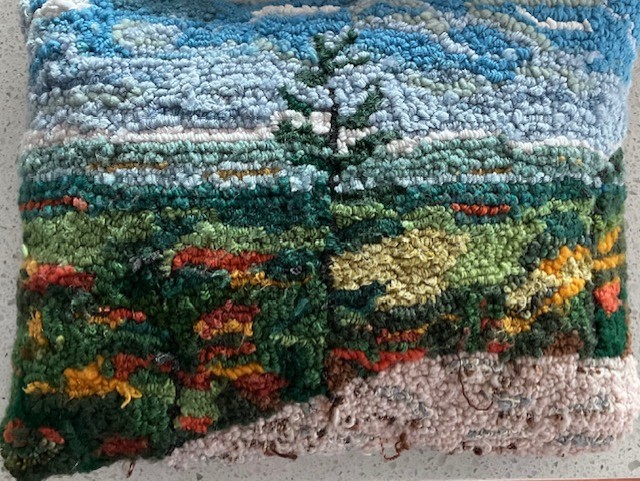 Tawadina Lookout, Gatineau Park by Marion Agnew
Tawadina Lookout is a scenic viewpoint in Gatineau Park, Québec, perched along the Eardley Escarpment and reached by hiking trails such as the Wolf Trail. The lookout offers sweeping views over the Gatineau Hills and the Ottawa River Valley, making it a popular destination for hikers seeking both natural beauty and elevation. Surrounded by forest and exposed rock, Tawadina Lookout exemplifies the rugged landscape of the park and rewards a steady climb with one of its more expansive inland vistas.
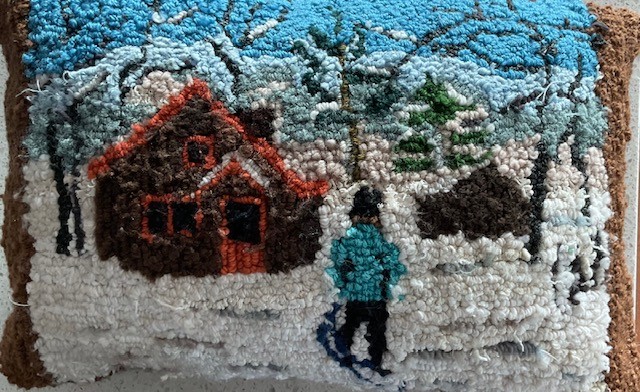 Huron cabin in winter, Gatineau Park by Marion Agnew
Huron Cabin: The Huron-Wendat played an important role in the early history of the Bytown area long before its founding in 1826. For centuries, they used the Ottawa River and its tributaries as major travel and trade routes, establishing camps and portages that later guided European movement through the region. Their knowledge of the land, waterways, and seasonal cycles shaped early exploration and settlement patterns and influenced relations between Indigenous peoples and newcomers. When Bytown emerged during the construction of the Rideau Canal, it did so on Indigenous land long known, used, and understood by the Huron-Wendat and other Algonquin-speaking peoples, whose presence formed an essential part of the area’s deeper historical foundation.
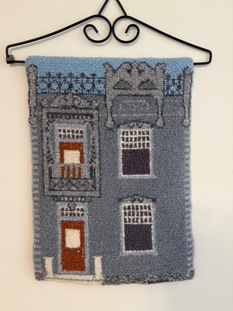
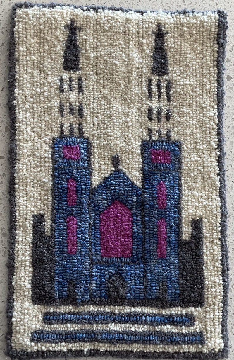 Notre-Dame Cathedral, Sussex Drive by Andre PInard
Notre-Dame Cathedral, Sussex Drive
Adapted logo with permission
Hooked by André Pinard
7 x 11 inches
Notre-Dame Cathedral Basilica of Ottawa is one of the city’s oldest and most important religious landmarks. Founded in 1841 as a small wooden church serving the Catholic community of Bytown, it evolved as the settlement grew during the construction of the Rideau Canal. The present stone cathedral, begun in 1846 under Bishop Joseph-Eugène-Bruno Guigues, was built in the Gothic Revival style using local stone and later enhanced by its distinctive twin tin spires. Its richly decorated interior reflects the artistic and cultural influence of French and Irish Catholic communities. Designated a minor basilica in 1879 by Pope Leo XIII, Notre-Dame remains a key symbol linking Ottawa’s early history to the modern capital.
The basilica holds deep family significance for André, as generations of his family were married, baptized, and received their first communion there. Parish registers show that Émélia Pinard, born in Bytown on June 25, 1829, daughter of Louis Pinard and Catherine Alexandre, was baptized the same day. Although no church building yet existed and the parish had not been formally established, missionary clergy were already keeping records, marking the Pinard family’s early connection to Notre-Dame.
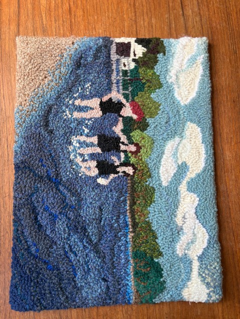 Girls on the Beach by Julie de Loë
Hog's Back Falls: Girls on the Beach
Rug hooked by Julie de Loë – Completed January 2026
Materials used: burlap backing, wool cloth and 100% wool
Description: Pictured are Claire Johnson, Mary Maingot and Frances Clark swimming at Hog’s Back Park/Mooney’s Bay, April 30, 1954. To the far left, the white building and boat house where Paul’s Boat Lines found its beginnings.
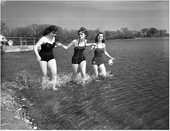 City of Ottawa Archives MG393-NP-31052-001 CA004093
Photo used with permission
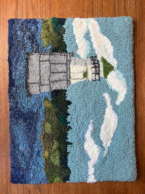 Green Shoal Lighthouse by Julie de Loë
Green Shoal Lighthouse
Rug hooked by Julie de Loë – Completed: January 2026
Materials used: Burlap Backing, wool cloth and 100% wool
Inspired by: Original photograph by Lou Bouchard Copyright 1964; Article and Drawing by Andrew King, Ottawa Rewind 2015/03/05.
Green Shoal is located in the middle of Ottawa River, about twelve kilometres downstream from Ottawa. It sits just north or the gap between Upper Duck Island and Lower Duck Island. Green Shoal Lighthouse was active into the early 1970s. The Green Shoal Lighthouse inspired the naming of the Beacon Hill neigbourhood as it was visible from the North part of this community.
Originally built in 1860, it received a new pier in 1900 and an updated light. It’s base is 20 feet in diameter and it rose to 23 feet above summer level of the river. The wooden tower stood 21 feet high and had a fixed white light. The light was 38 feet above the summer level of the river.
Today, only the steel-clad foundation remains standing in Ottawa River.
Keepers: George Barthgate (1860 – 1861), David Thomas (1861 – 1865), Mrs. D. Thomas (1865), Alfred Laberge (1866 – 1902), Albert Laberge (1902 – 1920), D. Mitchell (1920 – at least 1923).”
References: Annual Report of the Department of Marine, various years.
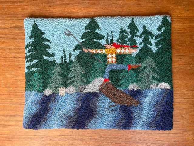 Log Driver's Waltz by Jule de Loë
Log Driver’s Waltz
Rug hooked by: Julie de Loë - Completed: Jnuary 2026
Materials used: burlap backing, wool cloth and 100% wool
Description: The Log Driver’s Waltz is a known Canadian folk song, written by Wade Hemsworth. The song was recorded by many artists Kate & Anna McGarrigle, Mountain City Four, Captain Tractor and The Hidden Cameras to name a few. The lyrics were translated in French by Philippe Tatartcheff.
In 1979 the National Film Board released this animated film as part of its Canada Vignette series. One of the most-requested in the collection of the National Film Board of Canada, it celebrates log drivers and the lumber industry.
This rug was inspired by the film and used with kind permission from the National Film Board of Canada.
 From the NFB film
Tin House
This is my last rug for the Ottawa Bicentenial project. Hooked in the Chéticamp style, it has 144 loops per square inch. The rug depicts the Tin House originally built in the 1860’s.
 Tin House by Julie de Loë
In 1900, Honoré Foisy, a second generation tin smith who lived in the house on Guigues Street covered the house in tin to showcase his skills and advertise his business. In 1960, the house underneath the tin fell into disrepair and was torn down. Stored for 10 years in less than ideal condition, the tin facade was rescued and restored by Art Price creating a bas-relief. This art installation can be found today in Tin House Court, in Ottawa’s Sussex Courtyards.
 Tin House courtyard
This rug is based on the original photo taken on Guigues Street before demolition.
 Tin House © Government of Canada. Reproduced with the permission of Library and Archives Canada (2026). Source: Library and Archives Canada/National Capital Commission collection/e999916344-u
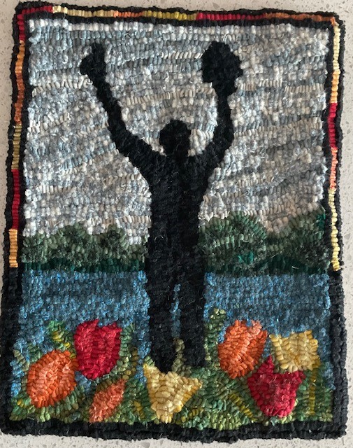
Man with Two Hats by Christine Tibelius
Man with Two Hats Designed and hooked by Christine Tibelius 2026
The statue is at Dow’s Lake in Ottawa in Commissioners Park, which is beside the lake. The statue is officially called The Man With Two Hats. It’s a bronze public sculpture about 4.6 m tall, showing a stylized human figure holding a hat in each hand. It was created by Dutch artist Henk Visch. The statue in Ottawa was unveiled on May 11, 2002 by Princess Margriet of the Netherlands.
The statue commemorates the role Canadian soldiers played in freeing the Netherlands from German occupation during the Second World War. Canada’s involvement meant a lot to the Dutch people, and as a sign of gratitude the Netherlands gifted this sculpture to Canada. There’s an identical statue in Apeldoorn, Netherlands (at the National Canadian Liberation Monument), and the two are symbolic “twins,” connecting the two countries across continents. The outstretched arms holding two hats can represent joy and celebration of freedom, the strong friendship between Canada and the Netherlands, and the shared history of liberation at the end of World War II.
Princess Margriet was actually born at the Ottawa Civic Hospital during the war — her mother stayed in Canada because the Dutch royal family was in exile — and that personal connection adds meaning to why the monument is in Ottawa.
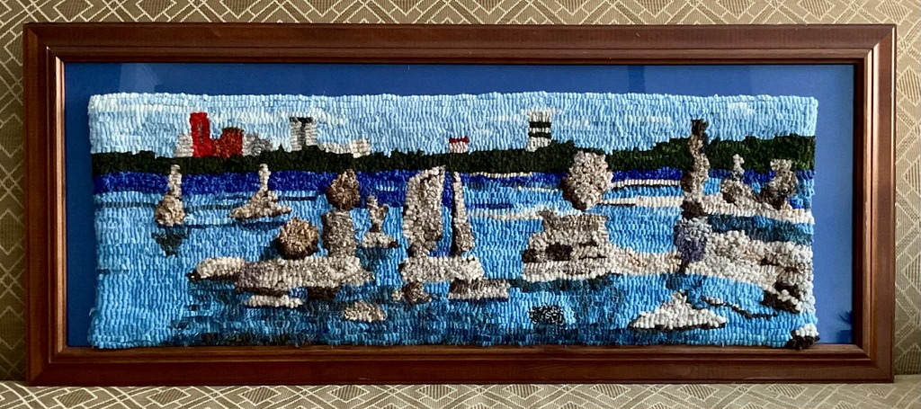 Joanne Dickert’s project depicting John Ceprano’s rock sculptures along the Ottawa River.
 Colonel By hooked rug by Jane Smith
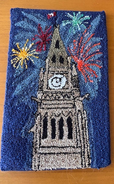 Parliament Hill Peace Tower by Elaine Armstrong.
Visit the OOFRH website to learn more about their organization: ottawarughooking.com
Rick Henderson – The Capital Builders
Rick Henderson is the great-great-great-great-grandson of Philemon Wright & Abigail Wyman and author of "Capital Chronicles".
Rick recounts the history of the region in four parts:
- The Curious Cast that Created Canada's Capital
- Bridging the Divide
- Canada's Capital - Set in Stone
- A Capital Route - Canal
Epi(b)logue - The Inglorious End of Two Glorious Men
The Chaudière Bridges
28 September 1826
Bridges are amazing structures. Spanning rivers, gorges, bays and even open ocean, they are testaments to the ingenuity of the engineers who designed them and the courage and ability of the workers who constructed them. Who hasn’t crossed a bridge and wondered what’s holding it up and experienced a frisson of excitement or even terror? The longest bridge in the world over water connects Hong Kong to Macau and the city of Zhuhai on the Chinese mainland, a distance of 55 kilometres, of which a 6.7-kilometre stretch midway is an under-water tunnel between two artificial islands to allow ocean-going ships to travel up the Pearl River estuary. It opened in 2018. Canada’s Confederation Bridge, which links Prince Edward Island to New Brunswick, is 12.9 kilometres long. At the other extreme is Bermuda’s Somerset Bridge that connects Somerset Island with the “mainland.” Dating back to 1620, it is reputedly the smallest drawbridge in the world. Operated by hand, it is just wide enough to allow a mast of a sailboat travelling between the Great Sound and Ely’s Harbour to pass through the gap.
In Canada’s capital, six bridges span the mighty Ottawa River: the Alexandra (or Interprovincial) Bridge; the Champlain Bridge; the Chaudière Bridge; the Macdonald-Cartier Bridge; the Portage Bridge; and the Prince of Wales Bridge (now closed). While the current Chaudière Bridge dates from 1919, it is the site of the first and for a long time the only bridge across the Ottawa River.
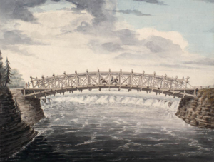
The need for a bridge crossing the Ottawa River became apparent after work commenced on the Rideau Canal in the summer of 1826 under the direction of Lieutenant Colonel John By of the Royal Engineers. With only wilderness on the Upper Canada side, workers and supplies had to be ferried across the river from Wright’s Town (later known as Hull) in Lower Canada, the only settlement of any consequence in the region, where labourers were billeted and shops and stores could be had. (American Philemon Wright had founded Wright’s Town in 1804.) As this was unsatisfactory to all, Colonel By and his engineering colleagues decided to build a bridge as quickly as possible, their haste probably encouraged by the approach of winter.
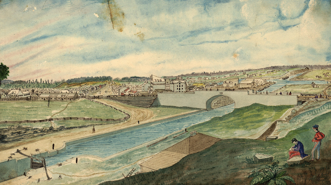
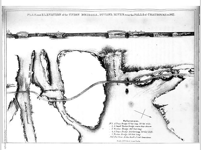 Plan and Elevation of the Union Bridge in Joseph Bouchette, The British Dominions in North America, London, 1832.
Their plan was to build a series of bridges to link Lower Canada on the northern shore of the Ottawa River to Upper Canada on the southern shore at the Chaudière Falls where the river temporarily narrows, using the islands mid-river as stepping stones. All were to be made of stone and masonry except for the widest section which was to be made of wood given the width of the gap, the depth of the water and the speed of the current. Col. By later modified this plan. Five of the seven bridges were made of wood—(from south to north over the river,) a 117-foot truss bridge, a small bridge over a deep chasm, a 160-foot bridge, a 212-foot truss bridge, a 180-foot bridge, and two limestone bridges.
After a quick survey—these were the days long before environmental assessments—construction began. On 28 September 1826, General George Ramsay, 9th Earl Dalhousie and Governor General of British North America, placed several George IV silver coins under a foundation stone on the Lower Canadian shore. Colonel Durnford of the Royal Engineers, Colonel John By, and a number of prominent area landowners, including Nicholas Sparks, Thomas McKay and Philemon Wright, attended the ceremony.
Three weeks into the construction, the first masonry arch on the Lower Canada side collapsed when the temporary supporting falsework was removed. Colonel By ordered work to recommence immediately with new plans drawn up by Thomas Burrowes, the assistant overseer of works. The new, hammered stone arch was completed by early January 1827 despite atrocious working conditions. Spray from the nearby falls froze thickly onto the workers’ clothes despite rough wooden screens being installed to shelter them. The second arch was finished by the summer of 1827.
The biggest challenge was bridging the Chaudière itself, also known in English as the Giant Kettle. To link its two sides, Captain Asterbrooks of the Royal Artillery fired a brass cannon loaded with a ½-inch rope to workmen on Chaudière Island. Twice he failed, the rope breaking. But he succeeded with a 1-inch rope. Once workers had a hold of it, they were able to haul over larger cables. Two ten-foot wooden trestles were constructed on either side with ropes stretched over their top and fastened to the rocks. The workers fashioned a precarious footbridge with a rope handrail. It swayed in the wind and sagged to within seven feet of the raging torrent beneath it. It must have been terrifying to cross. In his 1832 book The British Dominions in North America, Joseph Bouchette wrote: “We cannot forebear associating with our recollections of this picturesque bridge the heroism of a distinguished peeress [Countess Dalhousie], who we believe, was the first woman to venture across it.” The bridge’s ropes were then replaced with stronger chains. But as workmen were planking the floor of the bridge, the last step in its construction, disaster struck. First one then the other chain broke, throwing men and their equipment into the raging torrent. While accounts vary, as many as three men drowned.
Undeterred by the tragedy, Colonel By immediately got back to work. This time, workmen constructed stronger trestles and bridged the gap with two 8-inch link chain cables. Two large scows, a type of flat-bottomed boat, were built and moored securely in the location of the bridge. Jack screws placed on the scows supported the bridge during its construction. Unbelievably, just prior to the bridge’s completion, a strong gale flipped it over. Workmen were obliged to cut the bridge free which sent it sailing down the Ottawa river, coming to land close to the entrance of the Rideau Canal. Reportedly, the Chief workman, Mr. Drummond, shed tears in frustration.
Again, Colonel By persevered; his next bridge held. Supported by chains made of 1 3/4-inch thick iron and 10-inch links, the wooden bridge was 212 feet long, 30 feet wide and roughly 40 feet above the water, high enough to escape damage during the spring freshet. It was completed in the summer of 1828, two years after construction had commenced. Upper and Lower Canada were finally united. Fittingly, Col. By called it the Union Bridge.
Lieutenant Pooley, who worked for Col. By, supervised the construction of a final bridge needed to connect Bytown with the new Union Bridge. This bridge spanned a “gully” in what became LeBreton Flats. So impressed was Col. By with Pooley’s round-log bridge that he dubbed it “Pooley’s Bridge.” This name stuck. Lieutenant Pooley’s wooden bridge was replaced by a stone bridge in 1873. It was designated a heritage structure in 1982.
As the Union Bridge was funded by the Imperial Government, Colonel By instituted a toll to help pay for it. The cost was one penny per person, one penny for every horse, ox, cow, sheep and pig, and two pennies for every wagon and sleigh. This was a pretty steep tariff for the times.
Sadly, the Union Bridge did not last. In May 1836, it collapsed into the river and was swept away. Fortunately, there was nobody on it at the time. Again, the only way across the Ottawa River was by ferry.
This all changed in 1843 when the Union Suspension Bridge, constructed by Mr. Wilkinson, an American, opened for traffic. The bridge had a span of 242 feet. Its iron wire suspension cables, which were imported from Britain to Montreal and ferried to Bytown in barges, supported an oaken plank deck. It was the first of its kind in Canada, and was considered an engineering marvel of the age. The Packet opined that the bridge was “a beautiful piece of work” and that it “reflects great credit to the builder, Mr. Wilkinson.” A big celebration was held at Doran’s Hotel on Wellington Street to mark its opening. Engraved invitations were sent out to guests to attend the “Union Suspension Bridge Ball,” complete with a picture of the completed bridge.
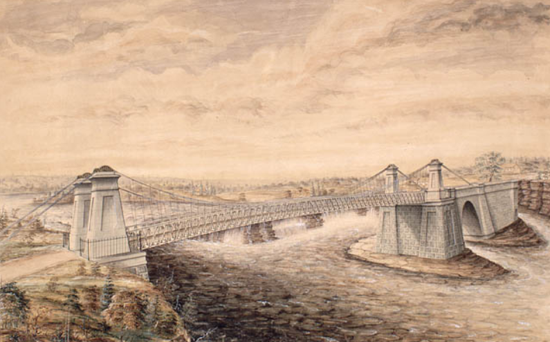 Union Suspension Bridge, Watercolour by F. P. Rubidge, Library and Archives Canada, Arch. Ref. R182-2.
Like its predecessor, the Union Suspension Bridge charged tolls. It was a profitable business. In the June to September period of 1851, Duncan Graham, appointed the (tax) Collector for Bytown in the Finance Department by Earl Cathcart, collected £303. 6s. 7d. (equivalent to more than $1,650) in tolls. This was almost enough to cover his annual salary of $1,500 and the monthly stipend £6. 5s. of Mr Mossop, the bridge keeper, who lived in the toll house rent free. Later, the government put the toll business out to tender. At the 1869 tender, the government set a reserve price of $2,000. This compares with annual tolls collected in the 1865-1868 period ranging from $2,500 to $3,350. The winner of the auction was required to maintain the toll house, and keep the bridge clean of rubbish. In winter, they were also responsible for snow clearance, but were required to leave six inches to facilitate sleigh traffic.
Bridge maintenance was not up to everybody’s standards. People complained that the bridge was dangerous especially at night as its railings were low and weak. “Persons run a very great risk on a dark night of driving into the ‘Devil’s Punch-bowl’” said the Ottawa Citizen. As well, the approaches to the bridge on either side of the river were nearly impassable during rainy weather owing to “the enormous quantity of mud and water collected.” In an agreement with the City, the Dominion government abolished tolls on the Union Suspension Bridge in 1885.
 The muddy and rutted entrance to the Union Suspension Bridge, looking towards Ottawa, Topley Studio, c. 1867-70, Library and Archives Canada, PA-012705.In 1889, the Dominion government appropriated $35,000 for a new iron truss bridge to replace the deteriorating Union Suspension Bridge. Messrs. Rousseau & Mather were the contractors. Work commenced at the beginning of August and was completed by the beginning of December of that year. Many were concerned that the 30-foot width of the new roadway was too narrow given the growing amount of traffic between Ottawa and Hull. Appeals to the government to widen the bridge or at least put the two 5-foot sidewalks on the outside of the trestles in order to increase the width of the roadway by 10 feet fell on deaf ears.
Twelve years later in 1900, the Great Fire, which destroyed much of Hull and LeBreton Flats, severely damaged the bridge. A vital thoroughfare, the government moved quickly to repair it.
In 1919, the Government condemned the Chaudière bridge as being unsafe. According to the Citizen, just walking over the old bridge was enough to give one “thrills” owing to its “see-saw motion when cars pass over it.” Dominion policemen ensured that too many vehicles didn’t try to cross the bridge at the same time. The replacement bridge was built by the Dominion Bridge Company at a cost of $110,000. It was assembled on the Quebec side and was moved into place using scows. This time, government listened to its critics, and placed the sidewalks on the outside of the piers. Before the new Chaudière bridge was put into position, the old bridge was lifted by four 50-ton hydraulic jacks, placed on rollers, and moved 50 feet downriver to a temporary location so that traffic across the river would not be unduly impeded by the construction.
In 2008, the Chaudière bridge was temporarily closed when an inspection revealed that its stone arches, some of which date back to that first 1820’s bridge, were no longer safe. Following repairs, the government reopened the bridge the following year. It continues to serve thousands of commuters every day.
Sources:
Bouchette, Joseph, 1832. The British Dominions in North America, Vol. 1, London: Longman, Rees, Orme, Brown, Green and Longman.
Bytown Gazette, 1846. “No title,” 14 September.
Canada, Province of, 1867. Report of the Minister of Agriculture for 1866, Ottawa: Hunter, Rose & Company.
Mika, Nick & Helma, 1982. Bytown, The early day of Ottawa, Belleville: Mika Publishing Company.
Ottawa Citizen, 1868. “Editorial,” 19 June.
——————, 1869. “Tolls on Union Suspension Bridge,” 26 July.
——————, 1908. “Civil Servants’ Income Tax,” 17 February.
——————, 1919. “Chaudiere Bridge Gives One Thrills,” 18 August.
——————, 1919. “Are Moving The Old Chaudiere Bridge,” 21 August.
——————, 1929. “Ottawa’s First Bridge And Other Narrations,” 12 October.
——————, 1933. “Chaudiere Toll Bridge 1851, Document Tells of Revenue,” 5 August.
——————, 1981. “By-Gone Days,” 28 February.
Ottawa Journal, 1889,” Supplementary Estimates,” 24 April.
——————, 1889. “The Chaudiere Bridge,” 19 September.
Packet (The), 1847. “The Ottawa-Slides-Steamers-Railroads-Necessary Improvements, etc.” 12 June.
Story written by James Powell, the author of the blog Today in Ottawa's History.
Retired from the Bank of Canada, James is the author or co-author of three books dealing with some aspect of Canadian history. These comprise: A History of the Canadian Dollar, 2005, Bank of Canada, The Bank of Canada of James Elliott Coyne: Challenges, Confrontation and Change,” 2009, Queen’s University Press, and with Jill Moxley, Faking It! A History of Counterfeiting in Canada, 2013, General Store Publishing House, Renfrew, Ontario. James is a Director of The Historical Society of Ottawa.
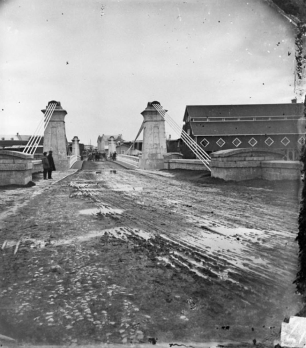
Sappers' Bridge
23 July 1912
It ended with a crash that sounded like a great gun going off, the noise reverberating off the buildings of downtown Ottawa. After faithfully serving the Capital for more than eighty years, Sappers’ Bridge finally succumbed to the wreckers in the wee hours of the morning of Tuesday, 23 July 1912. However, the old girl didn’t go gently into that good night. It took seven hours for the structure to finally collapse in pieces into the Rideau Canal below. After trying dynamite with little success, the demolition crew rigged a derrick and for hours repeatedly dropped a 2 ½ ton block onto the platform of the bridge before the arch spanning the Canal gave way. Mr. O’Toole the man in charge of the demolition, said that the bridge was “one of the best pieces of masonry that he [had] ever taken apart.”
 View of the Rideau Canal and Sappers’ Bridge – Painting by Thomas Burrowes, c. 1845, Archives of Ontario, Wikipedia.The bridge, the first and for many decades the only bridge across the Rideau Canal, dated back to the dawn of Bytown. In the summer of 1827, Thomas Burrowes, a member of Lieutenant Colonel John By’s staff, gave his boss a sketch of a proposed wooden bridge to span the Rideau Canal, which was then under construction, from the end of Rideau Street in Lower Bytown on the Canal’s eastern side to the opposing high ground on the western side. Colonel By accepted the proposal but opted in favour of building the bridge out of stone rather than wood. Work got underway almost immediately, with the foundation of the eastern pier begun by Mr. Charles Barrett, a civilian stone mason, though the vast majority of the workers were Royal Sappers and Miners. On 23 August 1827, Colonel By laid the bridge’s cornerstone with the name Sappers’ Bridge cut into it. The arch over the Canal was completed in only two months. On the keystone on the northern face of the bridge, Private Thomas Smith carved the Arms of the Board of Ordnance who owned the Canal and surrounding land. The original bridge was only eighteen feet wide and had no sidewalks.
Reportedly, one of the first civilians to cross Sappers’ Bridge was little Eliza Litle (later Milligan), the six-year old daughter of John Litle, a blacksmith who had set up a tent and workshop where the Château Laurier Hotel stands today. Apparently, Eliza was playing close to the Canal bank on the western side when she was frightened by some passing First Nations’ women. She ran screaming towards Sappers’ Bridge which was then under construction. A big sapper picked Eliza up and carried her over a temporary wooden walkway and dropped her off at her father’s smithy.
Back in those early days, there were two Bytowns. Most people lived in Lower Bytown. It had a population of about 1,500 souls, mostly French and Irish Catholics. The much smaller Upper Bytown, which was centred around Wellington Street roughly where the Supreme Court is situated today, had a population of no more than 500. This was where the community’s elite lived, mainly English and Scottish Protestants. The two distinct worlds, one rowdy and working class, the other stuffy and upper class, were linked by Sappers’ Bridge. While the bridge joined up Rideau Street on its eastern side, there was only a small footpath on its western side. The path wound its way around the base of Barrack Hill (later called Parliament Hill), which was then heavily wooded, past a cemetery on its south side that extended from roughly today’s Elgin Street to Metcalfe Street, until it reached the Wellington and Bank Streets intersection where Upper Bytown started. It wasn’t until 1849 that Sparks Street, which had previously run only from Concession Street (Bronson Avenue) to Bank Street, was linked directly to Sappers’ Bridge. During the 1840s, that stretch of path to Sappers’ Bridge was a lonely and desolate area. It was also dangerous, especially at night. It was the favourite haunt of the lawless who often attacked unwary travellers. Many a score was settled by somebody being turfed over the side of the bridge into the Canal. People travelled across Sappers’ Bridge in groups: there was safety in numbers.
Bytown, which became Ottawa in 1855, quickly outgrew the original narrow Sappers’ Bridge. In 1860, immediately prior the visit of the Prince of Wales who laid the cornerstone of the Centre Block on Parliament Hill, six-foot wide wooden pedestrian sidewalks supported by scaffolding were added to each side of the existing stone bridge. This permitted the entire 18-foot width of the bridge to be used for vehicular traffic.
But only ten years later, the bridge was again having difficulty in coping with traffic across the Rideau Canal. There was discussion on demolishing Sappers’ Bridge and replacing it with something much wider. The Ottawa Citizen opined that such talk verged on the sacrilegious as Sappers’ Bridge was “an old landmark in the history of Bytown.” The newspaper also thought that it was far too expensive to demolish especially as the bridge had “at least another century of wear in it.” It supported an alternative proposal to build a second bridge over the Canal.
In late 1871, work began on the construction of that second bridge across the Canal linking Wellington Street to Rideau Street, immediately to the north of Sappers’ Bridge. It was completed at a cost of $55,000 in 1874. It was called the Dufferin Bridge after Lord Dufferin, Canada’s Governor General at that time. Another $22,000 was spent on widening the old Sappers’ Bridge on which were laid the tracks of the horse-drawn Ottawa Street Passenger Railway.
Despite the upgrade, Ottawa residents were still not happy with the old bridge. Sappers’ Bridge was a quagmire after a rainstorm. On wag stated that “It is estimated that the present condition of the bridge has produced more new adjectives that all the bad whiskey in Lower Town.” One Mr. Whicher of the Marine and Fisheries Department was moved to write a 24-verse parody of Henry Wadsworth Longfellow’s poem The Bridge about Sappers’ Bridge. In it, he referred to “many thousands of mud-encumbered men, each bearing his splatter of nuisance.” He hoped that a gallant colonel “with a mine of powder, a pick and a sure fusee (sic)” would blow it up. His poem was well received when he recited it at Gowan’s Hall in Ottawa.
But it took another thirty-five years before the government contemplated doing just that. As part of Sir Wilfrid Laurier’s plan to beautify the city and make Ottawa “the Washington of the North,” the Grand Trunk Railway began in 1909 the construction of Château Laurier Hotel on the edge of Major’s Hill Park, and a new train station across the street. Getting wind of government plans to build a piazza in the triangular area above the canal between the Dufferin Bridge and Sappers’ Bridge in front of the new hotel, Mayor Hopewell suggested that Sappers’ Bridge might be widened as part of these plans in order to permit the planting of a boulevard of flowers and rockeries to hid the railway yards from pedestrians walking over the bridge. He also added that public lavatories might be installed beneath the piazza.
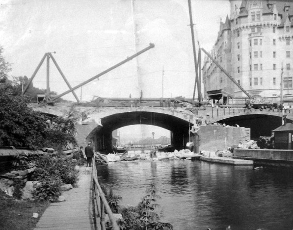 Demolition of Sappers’ Bridge, 1912. The arch of Sapper’s bridge is gone leaving only the broken abutments and rubble in the Canal. The newly built Château Laurier hotel in in the background on the right. Dufferin Bridge is in the centre of the photograph. Bytown Museum, P799, Ottawahh.In the event, the federal government decided to demolish Sappers’ Bridge. Both the Dufferin and Sappers’ Bridges were replaced by one large bridge—Plaza bridge. This new bridge was completed in December 1912. The piazza over the Canal was also built. It was bordered by the Château Laurier Hotel, Union Station, the Russell House Hotel and the General Post Office. A straw poll conducted by the Ottawa Citizen newspaper of its readership, favoured naming the new piazza “The Plaza.” However, the government, the owner of the site, had other ideas. It decided on calling it Connaught Place, after Lord Connaught, the third son (and seventh child) of Queen Victoria who had taken up his vice-regal duties as Canada’s Governor General in 1911.
In the 1920s and 1930s, the beautification of downtown Ottawa continued. The Federal District Commission, the forerunner of the National Capital Commission, expropriated the Russell Block of buildings and the Old Post Office to provide space for a national monument to honour Canada’s war dead. The war memorial was officially opened in 1939 by King George VI and Queen Elizabeth. In the process, Connaught Place was transformed into Confederation Square.
Little now remains of the old Sappers’ Bridge. Hidden underneath the Plaza Bridge is a small pile of stones preserved from the old bridge with a plaque installed by the NCC in 2004 in honour of Canadian military engineers. The bridge’s keystone with the chiselled emblem of the Ordnance Board was also saved from destruction. For a time it was housed in the government archives building but its current location is unknown.
Sources:
Ross, A. H. D. 1927. Ottawa Past and Present, Toronto: The Musson Book Company.
The Ottawa Citizen, 1871. “editorial,” 3 May.
————————, 1972. “A Dirty Bridge,” 10 April.
————————, 1874. “Sappers’ Bridge,” 9 October.
————————, 1913. “‘Connaught Place’, Cabinet’s Choice of Name for Area Formed By Union of Sappers’ and Dufferin Bridges,” 24 March.
————————, 1925. “Muddy Sappers’ Bridge In the Seventies,” 18 July.
———————–, 1928. “Girl of Six Was the First Female To Cross Sappers’ Bridge Over Canal,” 23 June.
The Ottawa Evening Journal, 1910. “Widening of the Bridges,” 3 June.
———————————–, 1912. “Early Days In Bytown Some Reminiscences,” 27 April.
———————————–, 1912. “When Ottawa Was Chosen The Capital of Canada,” 4 May.
———————————–, 1912. “Bridge Is Blown Down,” 23 July.
———————————–, 1914. “Notable Stones In the History Of The Capital,” 16 March.
Story written by James Powell, the author of the blog Today in Ottawa's History.
Retired from the Bank of Canada, James is the author or co-author of three books dealing with some aspect of Canadian history. These comprise: A History of the Canadian Dollar, 2005, Bank of Canada, The Bank of Canada of James Elliott Coyne: Challenges, Confrontation and Change,” 2009, Queen’s University Press, and with Jill Moxley, Faking It! A History of Counterfeiting in Canada, 2013, General Store Publishing House, Renfrew, Ontario. James is a Director of The Historical Society of Ottawa.
Colonel By Memorials
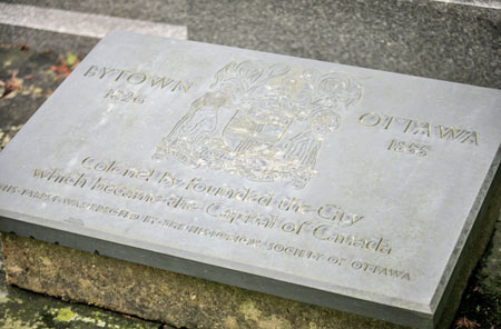 Plaque erected by the Historical Society of Ottawa in honour of Col. John By, founder of Bytown, later known as Ottawa. Photo by John Knight.The body of Lieutenant-Colonel John By, Royal Engineers, 1779-1836, is buried in St Alban’s Anglican Church in Frant, Sussex, England. Col. By supervised the building the Rideau Canal, and founded Bytown in 1826. In 1855, Bytown was renamed Ottawa. Two years later, Ottawa was selected by Queen Victoria to be the capital of the Province of Canada consisting of Canada West (Ontario) and Canada East (Quebec). With the Confederation of the Province of Canada, New Brunswick, and Nova Scotia on 1 July 1867, Ottawa became the capital of the Dominion of Canada.
For many years, the Historical Society of Ottawa provided funds for the maintenance of Colonel By’s resting place and memorial. For those wishing to visit St Alban’s, please consult the Church’s website.
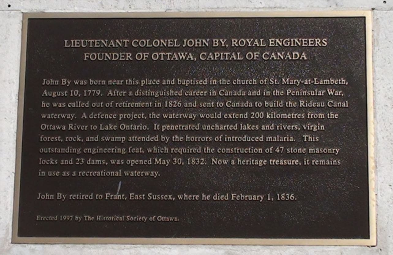 Image courtesy of LondonRemembers.com — see more about the John By memorial on the London Remembers website In 1997, the Historical Society of Ottawa erected a plaque in honour of Colonel By on the Albert Embankment in London near St Mary-at-Lambeth Church where he was baptized in 1779. Deconsecrated in 1972, St Mary-at-Lambeth is the home of The Garden Museum and is located next to Lambeth Palace, the London home of the Archbishop of Canterbury.
Our History
(Drawn from Mullington, Dave, 2013. “To Be Continued…A Short History of the Historical Society of Ottawa,” HSO Publication No. 88.)
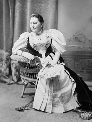 Lady Matilda Edgar, née Ridout, (1844-1910), wife of Sir James Edgar, Speaker of the House of Commons, chaired the inaugural meeting of the Women's Canadian Historical Society of Ottawa in 1898. Library and Archive Canada, PA-025868On June 3, 1898, thirty-one Ottawa women, united by a desire to preserve and conserve Canada’s historical heritage, assembled in the drawing room of the Speaker of the House of Commons located in the old Centre Block on Parliament Hill. Chairing the meeting was the prominent author and early feminist Lady Matilda Edgar (née Ridout) wife of Sir James Edgar, the Speaker. The cream of Ottawa society attended the meeting, including Lady Zoë Laurier, the wife of the then Liberal Prime Minister Sir Wilfrid Laurier, Mrs Adeline Foster, the wife of the prominent Conservative politician Mr (later Sir) George Eulas Foster, and Mrs Margaret Ahearn, the spouse of Mr Thomas Ahearn, the famous Ottawa-born inventor and businessman. The ladies agreed to form the Women’s Canadian Historical Society of Ottawa. As reported by the Ottawa Journal, they hoped “to resurrect from oblivion things of interest to every patriot Canadian woman, and preserve such things that are already treasures.”
Under its original 1898 Constitution, the objective of the Society was to encourage “the study of Canadian History and Literature, the collection and preservation of Canadian historical records and relics, and the fostering of Canadian loyalty and patriotism.” The Constitution also stressed that “neither political parties nor religious denominations” would be recognized. Adeline Foster was elected as the Society’s first president. Lady Aberdeen (née Ishbel Maria Marjoribanks), the wife of the Governor General, consented to be the Society’s patron, thereby establishing a link to Rideau Hall that continues to this very day. The annual membership fee was set at fifty cents. Initially, the Society was a women-only organization, though men sometimes participated as honorary members. This situation continued until 1955, when men were allowed to join the Society as full members.
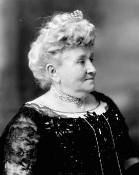 Lady Zoé Laurier, née Lafontaine, (1841-1921), wife of Sir Wilfrid Laurier, Prime Minister of Canada, was a founding member of the Women's Canadian Historical Society of Ottawa in 1898. Library and Archives Canada, PA-028100During the early years of the Society’s history, particular attention was paid to the collection and preservation of important artifacts and historical documents. The Society put on its first exhibition of historical objects in 1899. This collection, which was to expand greatly over the coming decades, went on permanent display with the opening in 1917 of the Bytown Historical Museum, located in the old Registry Office on Nicholas Street. The museum was staffed and operated by Society volunteers. Other activities included regular lectures and the publication of historical research. The Society was also instrumental in the erection of the statue of the French explorer Samuel de Champlain at Nepean Point in 1915. To celebrate Ottawa’s centenary in 1926, the Society unveiled a memorial to Lieutenant-Colonel John By, the Royal Engineer responsible for the construction of the Rideau Canal, and the founder of Bytown. A replica of his house, which had been destroyed by fire years earlier, was also built at Major’s Hill Park.
 Mrs Adeline Foster, née Chisholm, (1844-1919), wife of Mr (later Sir) George Eulas Foster, Conservative politician, first president of the Women's Canadian Historical Society of Ottawa. Library and Archives Canada, Mikan No. 3423435During the lean years of the Great Depression, the Society was forced to tailor its activities to suit the straitened financial circumstances. Its publications were cut back, and a ten cent fee began to be charged for museum entry. In 1930, the annual membership fee was also increased to one dollar. Notwithstanding the difficult economic situation, the Society continued to flourish. Its collection of historical artifacts and books expanded. Meetings, historical outings, and presentations were held regularly. In 1937, the Society was officially incorporated by the Province of Ontario. With the outbreak of World War II, Society activity slowed to allow members more time to support the war effort. The museum was closed for the duration. Nonetheless, membership meetings continued to be held, and the Society’s collection of antiquities grew through donation. Members also raised money for deserving wartime causes.
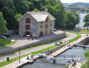 The Bytown Museum, formerly the Commissariat building, was built in 1827 and is the oldest stone building in OttawaFollowing the conclusion of the war, Society activities picked up. Particular attention was paid to finding a new home for the organization’s growing collection of historical artifacts and books; the old Registry Building was no longer adequate. In 1951, the Society leased premises from the federal government for a nominal fee in the Commissariat building adjacent to the Rideau Canal locks. The building, the oldest stone structure in Ottawa, was built by Scottish stonemasons hired by Colonel By during the construction of the Rideau Canal during the 1820s. Unfortunately, it was in a poor state of repairs; the building’s restoration and renovation occupied a considerable portion of the Society’s time, effort, and resources over coming years.
In 1955, there was a dramatic shift in the life of the Society. After vigorous debate, men were permitted to become full members of the Society in order to build a broader and stronger organization. The following year, the Society’s new name—the Historical Society of Ottawa—was officially adopted to reflect that change. Mr H. Townley Douglas, who had been previously active as an honorary member was elected as the Society’s first male director.
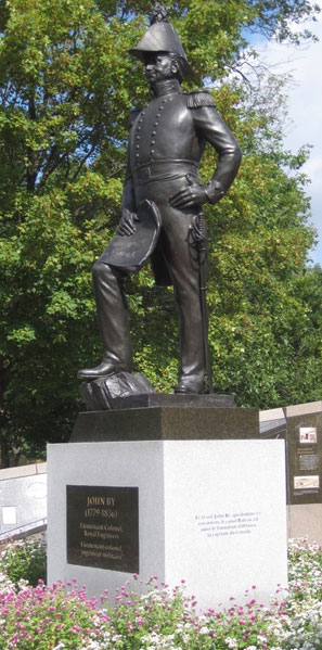 In Major's Hill Park stands the statue of Col. John By, Royal Engineers, who was responsible for building the Rideau Canal and the founding of Bytown, later renamed OttawaWhile the Bytown museum remained at the centre of the Society’s activities, the 1960s, under the leadership of Dr Bertram McKay, saw the HSO working hard for the erection of a statue in honour of Colonel By. Although Ottawa’s mayor at the time, Dr Charlotte Whitton, and City Council were supportive, it was up to the Historical Society to come up with the necessary funds. Raising $36,500 by 1969 (equivalent to more than $233,000 in today’s money), the Society hired the Quebec-born sculptor Joseph-Émile Brunet. On August 14, 1971, Governor General Roland Michener unveiled the bronze statue of Colonel By in Major’s Hill Park. Fittingly, the statue overlooked the Rideau Canal, itself a lasting memorial to the Colonel’s engineering abilities.
In 1981, the Society took a new step in its effort to increase public awareness of Ottawa and the Ottawa Valley’s rich history with the launch of a pamphlet series dedicated to that purpose. Its first publication was titled John Burrows and Others on the Rideau Waterway by a former Society president Charles Surtees. The pamphlet series continues to be an important feature of the Society’s efforts to increase public awareness about the history of Ottawa.
Through the 1980s and 1990s, the museum became an increasing preoccupation and concern for Society members. Forced to relocate temporarily due to restoration work conducted by the federal government at the Commissariat building and Rideau locks, attendance plummeted. Even when the Bytown Museum reopened at the Commissariat Building, the number of visitors was subsequently adversely affected by the reconstruction of Plaza Bridge. Declining membership, fewer volunteers, and rising costs owing to inflation also strained the Society’s ability to sustain the Museum in the manner it deserved. After considerable soul searching and debate, the difficult decision was made in 2003 to transfer the Bytown Museum to a separate not-for-profit organization. Roughly half of the artifacts and rare books collected over more than a century were loaned to the Museum; the loan became a permanent gift two years later. Considerable funds were also transferred to the new Museum Board to help launch the new organization.
Although now legally separate from the Historical Society of Ottawa, the Museum and the Society continue to cooperate closely. Over the following years, the Society transferred its remaining collection of items to other heritage organizations, most importantly the City of Ottawa Archives. A large collection of military medals was also offered to Canadian museums. Those medals that could not be placed were subsequently sold. In 2011, the proceeds of the sale helped to launch the Historical Society of Ottawa’s Research and Development Fund to support research into Ottawa’s history.
In 2013, the Society reviewed and approved revised “purposes and objectives” (Article 2 of its Constitution) in light of the many changes to the organization in recent years. Remaining true to the spirit of its founding members, the Society remains focused on increasing public awareness and knowledge of the history of Ottawa, the surrounding region, and their peoples. In cooperation with other heritage organizations, it also works to conserve archival materials, supports and encourages heritage conservation, and preserves the memory of Colonel By.
Quick Links
About
Supporting Partners